Follow the sequence
The circulation is identified
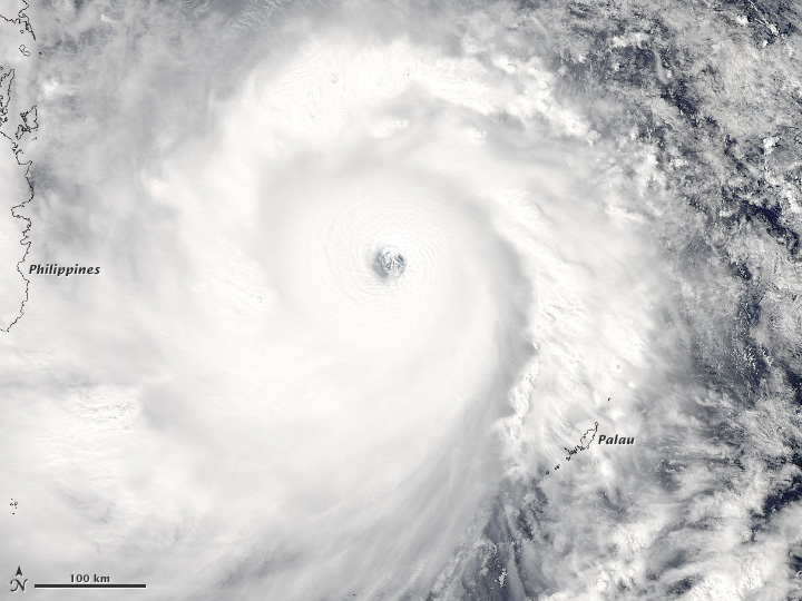
The WMO post-event mission report places tropical-depression formation southwest of Pohnpei at 06:00 UTC.
The Philippines crossing
Haiyan crossed the Philippines as a typhoon and entered the South China Sea later that day. Storm surge affected coastal communities in addition to wind and rain.
A later landfall farther north
After turning northwest and weakening, the system made landfall in Quang Ninh, Viet Nam. The track differed from an earlier possibility of crossing central Viet Nam.
Basis: World Meteorological Organization [1] · Soria et al., Bulletin of the American Meteorological Society [2]
Selected observations & analyses
These entries preserve the source’s reported quantities or analyses. They are not a newly processed observational dataset.
| Evidence | Reported value or finding | Provenance |
|---|---|---|
| Regional event chronology | 3–11 November 2013 | WMO post-typhoon mission report, using RSMC Tokyo best-track information. |
| Coastal evidence | Documented storm-surge flooding around Leyte | Post-event field and historical analysis by Soria and colleagues; observations differ among coastlines. |
| Viet Nam rainfall | 461 mm accumulated at Mauson | WMO mission report; reported event accumulation, exact start/end hours not specified in the summary. |
The atmospheric mechanism
Cyclone winds transfer momentum to the sea, and low pressure also affects water level. Coastal shape and shallow-water geometry determine how the water responds near shore. That is why the strongest wind estimate alone cannot supply a single surge height for an entire archipelago. The local tide and waves introduce additional components that must be distinguished from the meteorological surge.
A track is equally important. Moving a storm’s center relative to a bay changes the duration and direction of onshore winds. An educational wind diagram can illustrate Northern Hemisphere rotation, but the same circle cannot calculate water levels. For this case, the documented track, field evidence and coastal setting provide complementary pieces; photographs of debris alone cannot establish a peak water-level datum or the timing of the rise.
Basis: World Meteorological Organization [1] · Soria et al., Bulletin of the American Meteorological Society [2]
What the evidence does not establish
Wind estimates from different agencies can use different averaging periods and methods, so this page avoids ranking the storm using an unexplained mixture of categories. Reported surge, storm tide and inland inundation depth are not interchangeable measurements. The WMO mission describes communication and forecast context after the event; hindsight must not be presented as the exact information each resident had beforehand.
When reading a cyclone at a coast, add coastline orientation and the storm’s path to the wind map. Then check whether a quoted water level means surge, storm tide or depth above ground.
Sources & provenance
- Report of the WMO Post-Typhoon Haiyan Expert Mission to Viet Nam World Meteorological Organization · 2014-04Reference only; original paraphrase; no source media reproduced.
- Repeat Storm Surge Disasters of Typhoon Haiyan and Its 1897 Predecessor in the Philippines Soria et al., Bulletin of the American Meteorological Society · 2016Reference only; original paraphrase; no source media reproduced.
Explanations and diagrams are original educational interpretations. Source institutions have not endorsed or reviewed this publication. How we distinguish evidence from models.