Sources you can follow.
References stay attached to individual explanations and events. Image credits accompany every case.
Captions identify whether each image records the event, its aftermath or the region.
Reference use means original paraphrase and synthesis, not a licence to copy the source’s images or text. Source institutions have not endorsed this site.
Download the source and image registerImage credits
Hurricane Harvey Approaches Texas — natural-color Terra MODIS image
- Image credit
- NASA Earth Observatory / Joshua Stevens and Jesse Allen, using University of Wisconsin SSEC MODIS Direct Broadcast data. Source page also credits the NASA–NOAA GOES project for its separate animation.
- Creator
- Joshua Stevens and Jesse Allen; MODIS Direct Broadcast data from University of Wisconsin Space Science and Engineering Center
- Institution
- NASA Earth Observatory
- What the image shows
- Visible/natural-color satellite observation, not a ground photograph, radar image, forecast or accumulated precipitation map.
- Observation date
- 2017-08-25T17:25:00Z
- Source publication date
- 2017-08-26
- Source publication
- Hurricane Harvey Approaches Texas — natural-color Terra MODIS image
- Original image
- View the source image
- Reuse terms
- NASA Images and Media Usage Guidelines: factual editorial use permitted with acknowledgement and without implied endorsement. The image has no separately marked third-party copyright restriction.
- Reuse policy
- Read the reuse policy
- Changes made
- Source JPEG unchanged: the 720 × 540 rendition retains its original coastline/state outlines and scale bar. The main observation desk and case article preserve the full image frame. Separate interface buttons annotate the desk image; index thumbnails may crop responsively. No desaturation, fabricated cloud or added measurement is applied.
- Reuse scope
- NASA guidelines state no territorial limitation for factual editorial use; logos, endorsements and separately copyrighted third-party material are excluded from this permission assessment.

Making Sense of Holes in the Clouds — documentary satellite observation
- Image credit
- NASA Earth Observatory image by Michala Garrison, using MODIS data from NASA EOSDIS LANCE and GIBS/Worldview.
- Creator
- Michala Garrison; MODIS data from NASA EOSDIS LANCE and GIBS/Worldview
- Institution
- NASA Earth Observatory
- What the image shows
- Documentary natural-color satellite image, not a ground photograph, forecast, generated illustration or time animation.
- Observation date
- 2024-01-30
- Observation timing
- Source identifies the acquisition date but does not give a UTC clock time for this published rendition; no time has been inferred from a filename or article date.
- Source publication date
- 2024-02-26
- Source publication
- Making Sense of Holes in the Clouds — documentary satellite observation
- Original image
- View the source image
- Reuse terms
- NASA-produced imagery is generally not subject to copyright in the United States. NASA Images and Media Usage Guidelines permit factual educational and informational reuse with acknowledgement and without implied endorsement. This specific asset is credited to NASA Earth Observatory with NASA/NOAA instrument data and has no marked third-party copyright restriction.
- Reuse policy
- Read the reuse policy
- Changes made
- Source 720 × 480 JPEG downloaded byte-for-byte unchanged. Original NASA labels and scale bar retained. No recoloring, synthesized content or extra measured annotation applied. The case article should retain the full frame; index thumbnails may crop responsively.
- Reuse scope
- Public-domain statement is specific to the United States. NASA also grants educational/informational reuse under its guidelines without stating a territorial limitation; no claim of worldwide copyright status is made. NASA logos, implied endorsement and separately copyrighted material are excluded.

Swirly Clouds in the Canaries — documentary satellite observation
- Image credit
- NASA Earth Observatory image by Allison Nussbaum, using VIIRS data from NASA EOSDIS LANCE, GIBS/Worldview, and the Suomi National Polar-orbiting Partnership.
- Creator
- Allison Nussbaum; VIIRS data from NASA EOSDIS LANCE, GIBS/Worldview, and the Suomi National Polar-orbiting Partnership
- Institution
- NASA Earth Observatory
- What the image shows
- Documentary natural-color satellite image, not a ground photograph, forecast, generated illustration or time animation.
- Observation date
- 2023-03-19
- Observation timing
- Source identifies the acquisition date but does not give a UTC clock time for this published rendition; no time has been inferred from a filename or article date.
- Source publication date
- 2023-04-15
- Source publication
- Swirly Clouds in the Canaries — documentary satellite observation
- Original image
- View the source image
- Reuse terms
- NASA-produced imagery is generally not subject to copyright in the United States. NASA Images and Media Usage Guidelines permit factual educational and informational reuse with acknowledgement and without implied endorsement. This specific asset is credited to NASA Earth Observatory with NASA/NOAA instrument data and has no marked third-party copyright restriction.
- Reuse policy
- Read the reuse policy
- Changes made
- Source 720 × 480 JPEG downloaded byte-for-byte unchanged. Original NASA labels and scale bar retained. No recoloring, synthesized content or extra measured annotation applied. The case article should retain the full frame; index thumbnails may crop responsively.
- Reuse scope
- Public-domain statement is specific to the United States. NASA also grants educational/informational reuse under its guidelines without stating a territorial limitation; no claim of worldwide copyright status is made. NASA logos, implied endorsement and separately copyrighted material are excluded.

Floods Swamp Eastern Australia
- Image credit
- NASA Earth Observatory / Lauren Dauphin, using MODIS data from NASA EOSDIS LANCE and GIBS/Worldview.
- Creator
- NASA Earth Observatory / Lauren Dauphin, using MODIS data from NASA EOSDIS LANCE and GIBS/Worldview.
- Institution
- NASA
- What the image shows
- Documentary natural-color MODIS satellite scene; scattered clouds limit surface visibility.
- Observation date
- 2022-03-02
- Observation timing
- Published source gives the acquisition date but no clock time; no time inferred.
- Source publication date
- 2022-03-02
- Source publication
- Floods Swamp Eastern Australia
- Original image
- View the source image
- Reuse terms
- NASA-produced imagery is generally not subject to copyright in the United States. NASA Images and Media Usage Guidelines permit factual educational/informational reuse with acknowledgement and without implied endorsement; no separate third-party copyright restriction is marked on this asset.
- Reuse policy
- Read the reuse policy
- Changes made
- Downloaded NASA’s published JPEG, proportionally resized to a maximum 1600-pixel dimension and JPEG quality 82 with sips. Full source frame retained; no added labels, recoloring or generated content. Website thumbnails may crop responsively.
- Reuse scope
- NASA public-domain statement is specific to the United States. Its educational/informational reuse permission states no territorial restriction; no claim of worldwide public-domain status or NASA endorsement is made.

Britain on 19 July 2022
- Image credit
- NASA EOSDIS Worldview / GIBS, Aqua MODIS
- Creator
- NASA EOSDIS, Aqua MODIS
- Institution
- NASA Earthdata
- Observation date
- 2022-07-19
- Source publication date
- 2022-07-19
- Source publication
- Britain on 19 July 2022
- Original image
- View the source image
- Reuse terms
- NASA Earth Science image reuse with credit
- Reuse policy
- Read the reuse policy
- Changes made
- Unchanged JPEG extracted directly from the dated GIBS true-colour WMS layer for the listed regional extent.
- Reuse scope
- Reuse under NASA Earth Science terms with credit; no geographic restriction stated.
Storm Desmond on 5 December 2015
- Image credit
- NASA / LANCE Rapid Response MODIS; archived on Wikimedia Commons
- Creator
- NASA / LANCE Rapid Response MODIS; archived on Wikimedia Commons
- Institution
- NASA Earth Observatory
- What the image shows
- Real MODIS visible satellite imagery of Storm Desmond, published as a cropped image by a Commons contributor.
- Observation date
- 2015-12-05
- Observation timing
- The source gives the observation date but not an acquisition time or a specific Terra/Aqua platform. Current Commons rendition uploaded 9 January 2022; the first version was uploaded 6 December 2015.
- Source publication date
- 2022-01-09
- Source publication
- Storm Desmond on 5 December 2015
- Original image
- View the source image
- Reuse terms
- NASA-produced imagery is generally not subject to copyright in the United States. NASA permits factual educational and informational reuse with acknowledgement and without implied endorsement; this specific asset has no separately identified third-party copyright restriction.
- Reuse policy
- Read the reuse policy
- Changes made
- Downloaded Commons’ existing cropped PNG rendition unchanged. No new pixel changes or generated content. Website thumbnails may crop responsively.
- Reuse scope
- The public-domain statement is specific to the United States. NASA educational/informational reuse permission specifies no territorial restriction; no claim of worldwide public-domain status or NASA endorsement is made.


Kerry CD Storm Emma Assist
- Image credit
- Makopotato2412 — Kerry CD Storm Emma Assist / Wikimedia Commons
- Creator
- Makopotato2412
- Institution
- Wikimedia Commons; photographer’s own-work publication
- What the image shows
- Documentary ground photograph during Storm Emma, with people, an ambulance and snow-covered streets.
- Observation date
- 2018-03-02
- Observation timing
- Source camera metadata has a local-looking clock time but does not declare its time zone; no UTC time is assigned.
- Source publication date
- 2019-11-20
- Source publication
- Kerry CD Storm Emma Assist
- Original image
- View the source image
- Reuse terms
- Creative Commons Attribution-ShareAlike 4.0 International. Reuse requires attribution, a link to the licence and identification of changes; adaptations must retain the same or a compatible licence. The source identifies the photograph as the copyright holder’s own work.
- Reuse policy
- Read the reuse policy
- Changes made
- Downloaded the original published photograph unchanged. Website thumbnails may crop responsively; any such crop is an adaptation offered under the same Creative Commons licence. No retouching, recolouring or generated content.
- Reuse scope
- The Creative Commons licence applies internationally; its attribution and, where applicable, share-alike conditions remain in force.


The Pacific Northwest on 29 June 2021
- Image credit
- NASA EOSDIS Worldview / GIBS, Aqua MODIS
- Creator
- NASA EOSDIS, Aqua MODIS
- Institution
- NASA Earthdata
- Observation date
- 2021-06-29
- Source publication date
- 2021-06-29
- Source publication
- The Pacific Northwest on 29 June 2021
- Original image
- View the source image
- Reuse terms
- NASA Earth Science image reuse with credit
- Reuse policy
- Read the reuse policy
- Changes made
- Unchanged JPEG extracted directly from the dated GIBS true-colour WMS layer for the listed regional extent.
- Reuse scope
- Reuse under NASA Earth Science terms with credit; no geographic restriction stated.
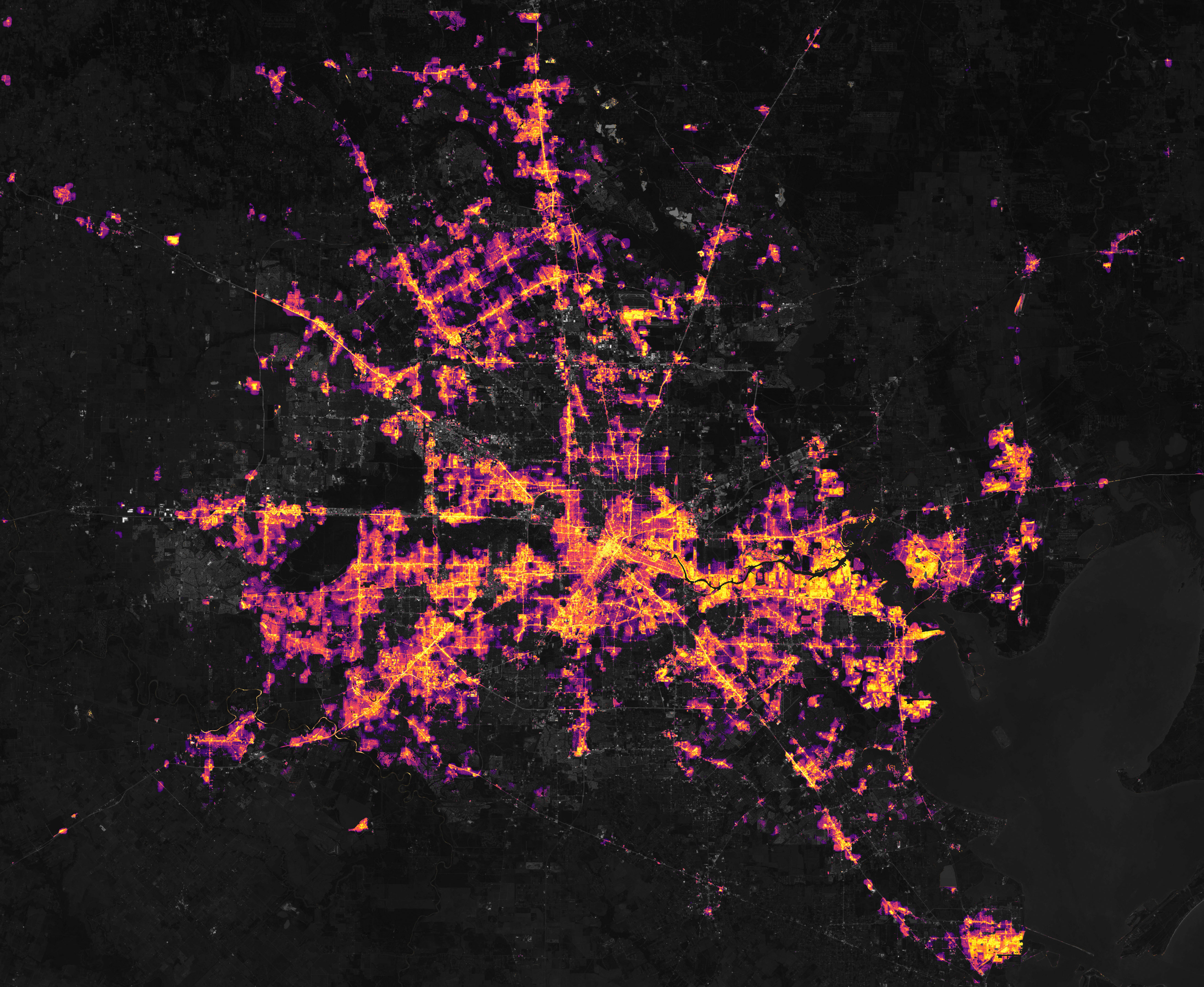
Extreme Winter Weather Causes U.S. Blackouts
- Image credit
- NASA Earth Observatory / Joshua Stevens, using Black Marble data courtesy of Ranjay Shrestha, NASA Goddard Space Flight Center, and Landsat data from the U.S. Geological Survey.
- Creator
- NASA Earth Observatory / Joshua Stevens, using Black Marble data courtesy of Ranjay Shrestha, NASA Goddard Space Flight Center, and Landsat data from the U.S. Geological Survey.
- Institution
- NASA Earth Observatory
- What the image shows
- NASA Black Marble processed VIIRS day/night-band data over a Landsat context image. The night-lights acquisition is event-dated; the background is not asserted to be from the same moment.
- Observation date
- 2021-02-16T07:00:00Z
- Observation timing
- Source says around 01:00 Central Standard Time on 16 February; approximately 07:00 UTC. Stored UTC time is approximate. Landsat background acquisition date is not specified on this page.
- Source publication date
- 2021-02-17
- Source publication
- Extreme Winter Weather Causes U.S. Blackouts
- Original image
- View the source image
- Reuse terms
- NASA-produced imagery is generally not subject to copyright in the United States. NASA Images and Media Usage Guidelines permit factual educational/informational reuse with acknowledgement and without implied endorsement; no separate third-party copyright restriction is marked on this asset.
- Reuse policy
- Read the reuse policy
- Changes made
- NASA’s published source proportionally resized to a maximum 1600-pixel dimension and saved as JPEG at quality 82 with sips; no crop, added measurement or generated content. Website thumbnails may crop responsively.
- Reuse scope
- NASA public-domain statement is specific to the United States. Its educational/informational reuse permission states no territorial restriction; no claim of worldwide public-domain status or NASA endorsement is made.
Tropical Cyclone Idai Aims at Mozambique
- Image credit
- NASA Earth Observatory / Lauren Dauphin; MODIS data from NASA EOSDIS/LANCE and GIBS/Worldview
- Creator
- NASA Earth Observatory / Lauren Dauphin; MODIS data from NASA EOSDIS/LANCE and GIBS/Worldview
- Institution
- NASA Earth Observatory
- What the image shows
- Real Terra MODIS satellite observation with NASA’s published historical-track, geographic-label and scale-bar overlays.
- Observation date
- 2019-03-12
- Observation timing
- The source gives the acquisition date but no precise clock time; no time is inferred.
- Source publication date
- 2019-03-13
- Source publication
- Tropical Cyclone Idai Aims at Mozambique
- Original image
- View the source image
- Reuse terms
- NASA-produced imagery is generally not subject to copyright in the United States. NASA permits factual educational and informational reuse with acknowledgement and without implied endorsement; this specific asset has no separately identified third-party copyright restriction.
- Reuse policy
- Read the reuse policy
- Changes made
- Downloaded the published image unchanged. Source labels, scale bars and any analytical overlays are retained. Website thumbnails may crop responsively; no generated content or added labels.
- Reuse scope
- The public-domain statement is specific to the United States. NASA educational/informational reuse permission specifies no territorial restriction; no claim of worldwide public-domain status or NASA endorsement is made.

Devastating Floods in Pakistan
- Image credit
- NASA Earth Observatory / Joshua Stevens, using Landsat data from the U.S. Geological Survey.
- Creator
- NASA Earth Observatory / Joshua Stevens, using Landsat data from the U.S. Geological Survey.
- Institution
- NASA
- What the image shows
- Documentary false-color satellite composite from a single Landsat acquisition; the colors are a spectral-band display rather than natural eyesight.
- Observation date
- 2022-08-28
- Observation timing
- Published source gives the acquisition date but no clock time; no time inferred.
- Source publication date
- 2022-09-01
- Source publication
- Devastating Floods in Pakistan
- Original image
- View the source image
- Reuse terms
- NASA-produced imagery is generally not subject to copyright in the United States. NASA Images and Media Usage Guidelines permit factual educational/informational reuse with acknowledgement and without implied endorsement; no separate third-party copyright restriction is marked on this asset.
- Reuse policy
- Read the reuse policy
- Changes made
- Downloaded NASA’s published JPEG, proportionally resized to a maximum 1600-pixel dimension and JPEG quality 82 with sips. Full source frame retained; no added labels, recoloring or generated content. Website thumbnails may crop responsively.
- Reuse scope
- NASA public-domain statement is specific to the United States. Its educational/informational reuse permission states no territorial restriction; no claim of worldwide public-domain status or NASA endorsement is made.

Floods Engulf Porto Alegre
- Image credit
- NASA Earth Observatory / Wanmei Liang, using MODIS data from NASA EOSDIS LANCE and GIBS/Worldview.
- Creator
- NASA Earth Observatory / Wanmei Liang, using MODIS data from NASA EOSDIS LANCE and GIBS/Worldview.
- Institution
- NASA
- What the image shows
- Natural-color MODIS before/during comparison assembled by NASA; two real acquisition dates, not one simultaneous scene.
- Observation dates
- 2024-05-06 · 2024-04-20
- Observation timing
- Two date-specific MODIS scenes in a source-provided comparison; upper scene 6 May, lower scene 20 April. No clock times supplied.
- Source publication date
- 2024-05-09
- Source publication
- Floods Engulf Porto Alegre
- Original image
- View the source image
- Reuse terms
- NASA-produced imagery is generally not subject to copyright in the United States. NASA Images and Media Usage Guidelines permit factual educational/informational reuse with acknowledgement and without implied endorsement; no separate third-party copyright restriction is marked on this asset.
- Reuse policy
- Read the reuse policy
- Changes made
- Downloaded NASA’s published JPEG, proportionally resized to a maximum 1600-pixel dimension and JPEG quality 82 with sips. Full source frame retained; no added labels, recoloring or generated content. Website thumbnails may crop responsively.
- Reuse scope
- NASA public-domain statement is specific to the United States. Its educational/informational reuse permission states no territorial restriction; no claim of worldwide public-domain status or NASA endorsement is made.

2018-07-14 Floods of Mabi, Kurashiki City — Oda River levee breach
- Image credit
- 松岡明芳 — Floods of Mabi, Kurashiki City, 14 July 2018 / Wikimedia Commons
- Creator
- 松岡明芳
- Institution
- Wikimedia Commons; photographer’s own-work publication
- What the image shows
- Documentary ground photograph of a damaged levee after the July 2018 floods.
- Observation date
- 2018-07-14
- Observation timing
- The source and camera metadata give 14 July 2018 at 08:44:23, without a declared time zone; only the date is used.
- Source publication date
- 2019-10-26
- Source publication
- 2018-07-14 Floods of Mabi, Kurashiki City — Oda River levee breach
- Original image
- View the source image
- Reuse terms
- Creative Commons Attribution-ShareAlike 4.0 International. Reuse requires attribution, a link to the licence and identification of changes; adaptations must retain the same or a compatible licence. The source identifies the photograph as the copyright holder’s own work.
- Reuse policy
- Read the reuse policy
- Changes made
- Downloaded the original published photograph unchanged. Website thumbnails may crop responsively; any such crop is an adaptation offered under the same Creative Commons licence. No retouching, recolouring or generated content.
- Reuse scope
- The Creative Commons licence applies internationally; its attribution and, where applicable, share-alike conditions remain in force.


Hagibis Floods Japan
- Image credit
- NASA Earth Observatory / Joshua Stevens; LAADS and LANCE MODIS data
- Creator
- NASA Earth Observatory / Joshua Stevens; LAADS and LANCE MODIS data
- Institution
- NASA Earth Observatory
- What the image shows
- Real Aqua MODIS natural-colour satellite observation after landfall, retaining NASA geographic labels and scale bar.
- Observation date
- 2019-10-13
- Observation timing
- The source gives the acquisition date but no precise clock time; no time is inferred.
- Source publication date
- 2019-10-16
- Source publication
- Hagibis Floods Japan
- Original image
- View the source image
- Reuse terms
- NASA-produced imagery is generally not subject to copyright in the United States. NASA permits factual educational and informational reuse with acknowledgement and without implied endorsement; this specific asset has no separately identified third-party copyright restriction.
- Reuse policy
- Read the reuse policy
- Changes made
- Downloaded the published image unchanged. Source labels, scale bars and any analytical overlays are retained. Website thumbnails may crop responsively; no generated content or added labels.
- Reuse scope
- The public-domain statement is specific to the United States. NASA educational/informational reuse permission specifies no territorial restriction; no claim of worldwide public-domain status or NASA endorsement is made.

Super Typhoon Haiyan
- Image credit
- NASA / LANCE–EOSDIS MODIS Rapid Response Team, Goddard Space Flight Center
- Creator
- NASA / LANCE–EOSDIS MODIS Rapid Response Team, Goddard Space Flight Center
- Institution
- NASA Earth Observatory
- What the image shows
- Real Aqua MODIS natural-colour observation with NASA geographic labels and scale bar.
- Observation date
- 2013-11-07
- Observation timing
- The source explicitly states 04:25 UTC (13:25 local time).
- Source publication date
- 2013-11-07
- Source publication
- Super Typhoon Haiyan
- Original image
- View the source image
- Reuse terms
- NASA-produced imagery is generally not subject to copyright in the United States. NASA permits factual educational and informational reuse with acknowledgement and without implied endorsement; this specific asset has no separately identified third-party copyright restriction.
- Reuse policy
- Read the reuse policy
- Changes made
- Downloaded the published image unchanged. Source labels, scale bars and any analytical overlays are retained. Website thumbnails may crop responsively; no generated content or added labels.
- Reuse scope
- The public-domain statement is specific to the United States. NASA educational/informational reuse permission specifies no territorial restriction; no claim of worldwide public-domain status or NASA endorsement is made.

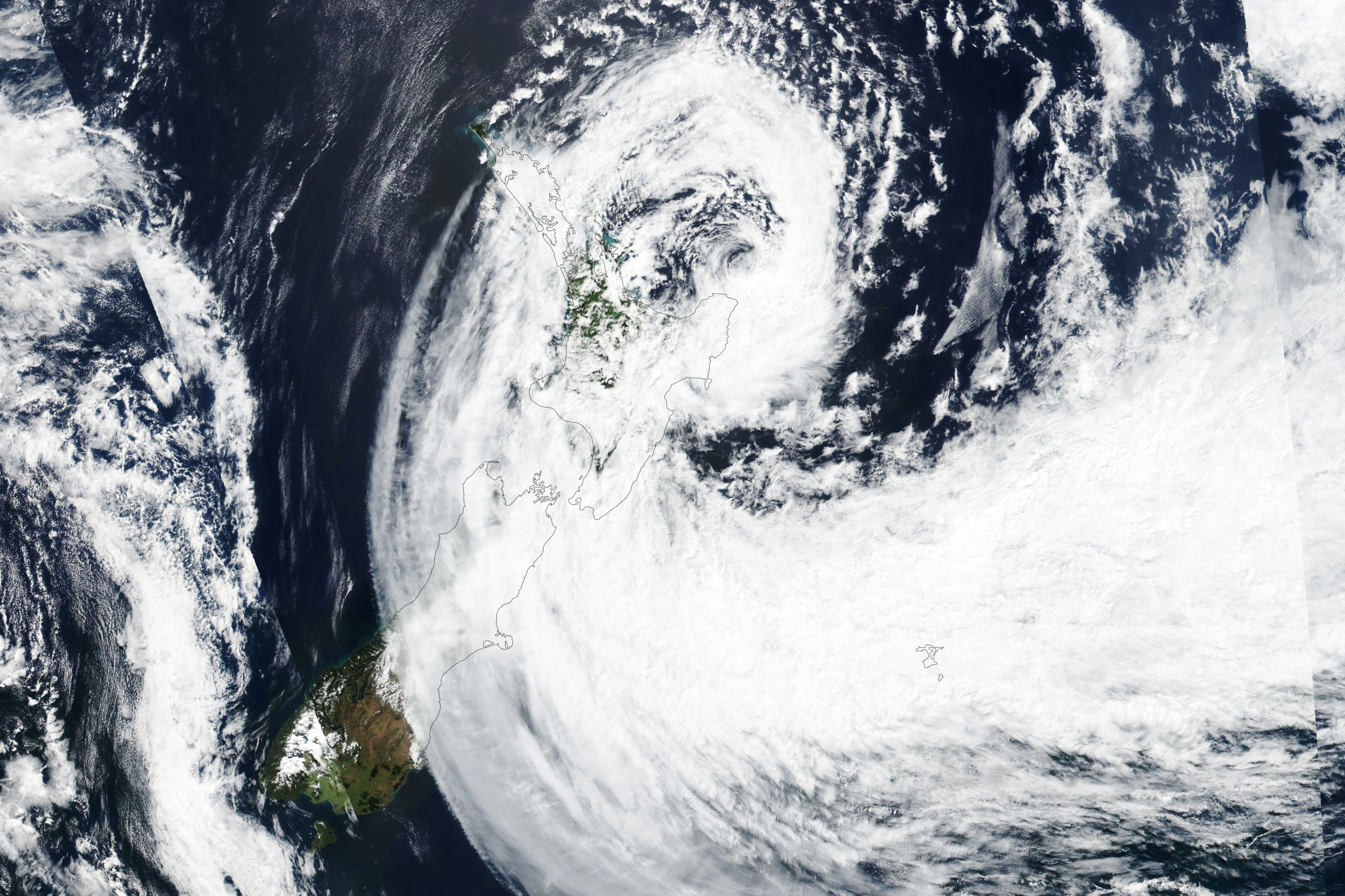
Cyclone Gabrielle Lashes New Zealand
- Image credit
- NASA Earth Observatory / Lauren Dauphin, using VIIRS data from NASA EOSDIS LANCE, GIBS/Worldview, and the Suomi National Polar-orbiting Partnership.
- Creator
- NASA Earth Observatory / Lauren Dauphin, using VIIRS data from NASA EOSDIS LANCE, GIBS/Worldview, and the Suomi National Polar-orbiting Partnership.
- Institution
- NASA
- What the image shows
- Documentary satellite cloud view; NASA reports the acquisition clock time as approximate.
- Observation date
- 2023-02-14T02:00:00Z
- Source publication date
- 2023-02-15
- Source publication
- Cyclone Gabrielle Lashes New Zealand
- Original image
- View the source image
- Reuse terms
- NASA-produced imagery is generally not subject to copyright in the United States. NASA Images and Media Usage Guidelines permit factual educational/informational reuse with acknowledgement and without implied endorsement; no separate third-party copyright restriction is marked on this asset.
- Reuse policy
- Read the reuse policy
- Changes made
- Downloaded NASA’s published JPEG, proportionally resized to a maximum 1600-pixel dimension and JPEG quality 82 with sips. Full source frame retained; no added labels, recoloring or generated content. Website thumbnails may crop responsively.
- Reuse scope
- NASA public-domain statement is specific to the United States. Its educational/informational reuse permission states no territorial restriction; no claim of worldwide public-domain status or NASA endorsement is made.
Clouds off KwaZulu-Natal on 12 April 2022
- Image credit
- NASA EOSDIS Worldview / GIBS, Terra MODIS
- Creator
- NASA EOSDIS, Terra MODIS
- Institution
- NASA Earthdata
- Observation date
- 2022-04-12
- Source publication date
- 2022-04-12
- Source publication
- Clouds off KwaZulu-Natal on 12 April 2022
- Original image
- View the source image
- Reuse terms
- NASA Earth Science image reuse with credit
- Reuse policy
- Read the reuse policy
- Changes made
- Unchanged JPEG extracted directly from the dated GIBS true-colour WMS layer for the listed regional extent.
- Reuse scope
- Reuse under NASA Earth Science terms with credit; no geographic restriction stated.
Dust over Eastern Australia
- Image credit
- NASA / Jeff Schmaltz, MODIS Rapid Response Team, Goddard Space Flight Center
- Creator
- NASA / Jeff Schmaltz, MODIS Rapid Response Team, Goddard Space Flight Center
- Institution
- NASA Earth Observatory
- What the image shows
- Real Terra MODIS natural-colour observation of the eastern Australian dust plume, retaining NASA labels and scale bar.
- Observation date
- 2009-09-23
- Observation timing
- The source describes morning acquisition without a precise clock time.
- Source publication date
- 2009-09-24
- Source publication
- Dust over Eastern Australia
- Original image
- View the source image
- Reuse terms
- NASA-produced imagery is generally not subject to copyright in the United States. NASA permits factual educational and informational reuse with acknowledgement and without implied endorsement; this specific asset has no separately identified third-party copyright restriction.
- Reuse policy
- Read the reuse policy
- Changes made
- Downloaded the published image unchanged. Source labels, scale bars and any analytical overlays are retained. Website thumbnails may crop responsively; no generated content or added labels.
- Reuse scope
- The public-domain statement is specific to the United States. NASA educational/informational reuse permission specifies no territorial restriction; no claim of worldwide public-domain status or NASA endorsement is made.

Bushfires in Southeast Australia
- Image credit
- NASA / MODIS Rapid Response Team, Goddard Space Flight Center
- Creator
- NASA / MODIS Rapid Response Team, Goddard Space Flight Center
- Institution
- NASA Earth Observatory
- What the image shows
- Real Aqua MODIS natural-colour observation with source fire-detection outlines and geographic labels.
- Observation date
- 2009-02-07
- Observation timing
- The source gives the acquisition date but no precise clock time; no time is inferred.
- Source publication date
- 2009-02-07
- Source publication
- Bushfires in Southeast Australia
- Original image
- View the source image
- Reuse terms
- NASA-produced imagery is generally not subject to copyright in the United States. NASA permits factual educational and informational reuse with acknowledgement and without implied endorsement; this specific asset has no separately identified third-party copyright restriction.
- Reuse policy
- Read the reuse policy
- Changes made
- Downloaded the published image unchanged. Source labels, scale bars and any analytical overlays are retained. Website thumbnails may crop responsively; no generated content or added labels.
- Reuse scope
- The public-domain statement is specific to the United States. NASA educational/informational reuse permission specifies no territorial restriction; no claim of worldwide public-domain status or NASA endorsement is made.

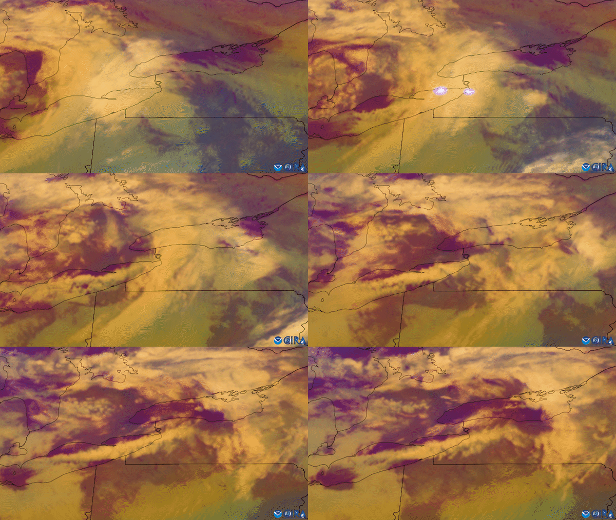
GOES-16 air-mass/lightning composite during the November 2022 lake-effect snowstorm
- Image credit
- NOAA / NESDIS, GOES-16
- Creator
- NOAA / NESDIS, GOES-16
- Institution
- NOAA NESDIS
- What the image shows
- Still from a real GOES-16 satellite air-mass/lightning data composite; it uses false colour and must not be described as a natural-colour photograph.
- Observation date
- 2022-11-17/2022-11-20
- Observation timing
- The article dates the event animation to 17–20 November 2022, without identifying the extracted frame’s acquisition time. The date interval records that precision; the filename is not used to infer a more precise timestamp.
- Source publication date
- 2022-12-29
- Source publication
- GOES-16 air-mass/lightning composite during the November 2022 lake-effect snowstorm
- Original image
- View the source image
- Reuse terms
- The NOAA source page explicitly permits downloading and repurposing all its images with credit to NOAA. This asset is credited solely to NOAA and no separate third-party restriction is given.
- Reuse policy
- Read the reuse policy
- Changes made
- Extracted the first frame of NOAA’s published GIF into a static PNG using sips, retaining frame dimensions and colours. No other pixel editing or generated content. Website thumbnails may crop responsively.
- Reuse scope
- NOAA’s explicit image-repurposing permission on the source page states no territorial restriction; attribution to NOAA is retained and no endorsement is implied.
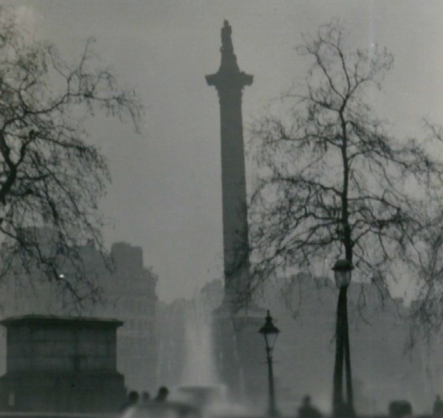
Nelson’s Column in December
- Image credit
- N T Stobbs — Nelson’s Column in December / Geograph, photo 765606
- Creator
- N T Stobbs
- Institution
- Geograph Britain and Ireland; photographer’s licensed publication
- What the image shows
- Documentary black-and-white photograph of London fog dated December 1952. Period context only: the specific Great Smog dates are not established by the photographer.
- Observation date
- 1952-12
- Observation timing
- Only December 1952 is established by the photographer’s original record. No day or clock time is inferred.
- Source publication date
- 2008-04-16
- Source publication
- Nelson’s Column in December
- Original image
- View the source image
- Reuse terms
- Creative Commons Attribution-ShareAlike 2.0 Generic. The photographer’s primary Geograph page provides this licence: reuse requires attribution, a licence link and retention of the same licence for adaptations.
- Reuse policy
- Read the reuse policy
- Changes made
- Downloaded the original published photograph unchanged. Website thumbnails may crop responsively; any such crop is an adaptation offered under the same Creative Commons licence. No retouching, recolouring or generated content.
- Reuse scope
- The Creative Commons licence applies internationally; its attribution and, where applicable, share-alike conditions remain in force.
Dust Traverses the Atlantic Ocean
- Image credit
- NASA Earth Observatory / Joshua Stevens, using imagery from the Deep Space Climate Observatory (DSCOVR).
- Creator
- NASA Earth Observatory / Joshua Stevens, using imagery from the Deep Space Climate Observatory (DSCOVR).
- Institution
- NASA Earth Observatory
- What the image shows
- Documentary EPIC natural-color satellite rendering from spectral observations; not the GEOS model map also present on the source page.
- Observation date
- 2020-06-18
- Observation timing
- The article supplies an acquisition date but no exact clock time.
- Source publication date
- 2020-06-20
- Source publication
- Dust Traverses the Atlantic Ocean
- Original image
- View the source image
- Reuse terms
- NASA-produced imagery is generally not subject to copyright in the United States. NASA Images and Media Usage Guidelines permit factual educational/informational reuse with acknowledgement and without implied endorsement; no separate third-party copyright restriction is marked on this asset.
- Reuse policy
- Read the reuse policy
- Changes made
- NASA’s published source proportionally resized to a maximum 1600-pixel dimension and saved as JPEG at quality 82 with sips; no crop, added measurement or generated content. Website thumbnails may crop responsively.
- Reuse scope
- NASA public-domain statement is specific to the United States. Its educational/informational reuse permission states no territorial restriction; no claim of worldwide public-domain status or NASA endorsement is made.

The Dutch coast on 3 August 2009
- Image credit
- NASA EOSDIS Worldview / GIBS, Aqua MODIS
- Creator
- NASA EOSDIS, Aqua MODIS
- Institution
- NASA Earthdata
- Observation date
- 2009-08-03
- Source publication date
- 2009-08-03
- Source publication
- The Dutch coast on 3 August 2009
- Original image
- View the source image
- Reuse terms
- NASA Earth Science image reuse with credit
- Reuse policy
- Read the reuse policy
- Changes made
- Unchanged JPEG extracted directly from the dated GIBS true-colour WMS layer for the listed regional extent.
- Reuse scope
- Reuse under NASA Earth Science terms with credit; no geographic restriction stated.
Antarctica Melts Under Its Hottest Days on Record
- Image credit
- NASA Earth Observatory / Joshua Stevens, using Landsat data from the U.S. Geological Survey.
- Creator
- NASA Earth Observatory / Joshua Stevens, using Landsat data from the U.S. Geological Survey.
- Institution
- NASA Earth Observatory
- What the image shows
- Documentary Landsat satellite observation seven days after the case’s station-temperature event; related regional aftermath, not a contemporaneous Esperanza station photograph.
- Observation date
- 2020-02-13
- Observation timing
- The article supplies an acquisition date but no exact clock time.
- Source publication date
- 2020-02-21
- Source publication
- Antarctica Melts Under Its Hottest Days on Record
- Original image
- View the source image
- Reuse terms
- NASA-produced imagery is generally not subject to copyright in the United States. NASA Images and Media Usage Guidelines permit factual educational/informational reuse with acknowledgement and without implied endorsement; no separate third-party copyright restriction is marked on this asset.
- Reuse policy
- Read the reuse policy
- Changes made
- NASA’s published source proportionally resized to a maximum 1600-pixel dimension and saved as JPEG at quality 82 with sips; no crop, added measurement or generated content. Website thumbnails may crop responsively.
- Reuse scope
- NASA public-domain statement is specific to the United States. Its educational/informational reuse permission states no territorial restriction; no claim of worldwide public-domain status or NASA endorsement is made.

Snow in Wellington, New Zealand, 15 August 2011
- Image credit
- Phillip Capper — Snow in Wellington, New Zealand, 15 August 2011 / Flickr and Wikimedia Commons
- Creator
- Phillip Capper
- Institution
- Phillip Capper / Flickr; archived on Wikimedia Commons
- What the image shows
- Documentary ground photograph of snowfall in Wellington during the August 2011 cold outbreak.
- Observation date
- 2011-08-15
- Observation timing
- The dated source does not establish a UTC capture time. Original photographer URL: https://www.flickr.com/photos/flissphil/6044933112/
- Source publication date
- 2011-08-15
- Source publication
- Snow in Wellington, New Zealand, 15 August 2011
- Original image
- View the source image
- Reuse terms
- Creative Commons Attribution 2.0 Generic. The original photographer’s Flickr release, archived and licence-reviewed on Wikimedia Commons, permits reuse and adaptations with the prescribed attribution and a link to the licence.
- Reuse policy
- Read the reuse policy
- Changes made
- Downloaded the published photograph unchanged. Website thumbnails may crop responsively; no retouching, recolouring or generated content.
- Reuse scope
- The Creative Commons licence applies internationally; its attribution and, where applicable, share-alike conditions remain in force.


Long Shadows of Mongolian Mountains
- Image credit
- NASA / Expedition 70 crew; ISS Crew Earth Observations Facility and Earth Science and Remote Sensing Unit, NASA Johnson Space Center. Photograph ISS070-E-80527.
- Creator
- NASA / Expedition 70 crew; ISS Crew Earth Observations Facility and Earth Science and Remote Sensing Unit, NASA Johnson Space Center. Photograph ISS070-E-80527.
- Institution
- NASA
- What the image shows
- Real astronaut photograph from the same winter; contextual evidence of snow-covered terrain only. NASA’s published rendition was cropped and contrast-enhanced and had lens artifacts removed.
- Observation date
- 2024-01-25
- Observation timing
- Published source gives the acquisition date but no clock time; no time inferred.
- Source publication date
- 2024-05-26
- Source publication
- Long Shadows of Mongolian Mountains
- Original image
- View the source image
- Reuse terms
- NASA-produced imagery is generally not subject to copyright in the United States. NASA Images and Media Usage Guidelines permit factual educational/informational reuse with acknowledgement and without implied endorsement; no separate third-party copyright restriction is marked on this asset.
- Reuse policy
- Read the reuse policy
- Changes made
- Downloaded NASA’s published JPEG, proportionally resized to a maximum 1600-pixel dimension and JPEG quality 82 with sips. Full source frame retained; no added labels, recoloring or generated content. Website thumbnails may crop responsively.
- Reuse scope
- NASA public-domain statement is specific to the United States. Its educational/informational reuse permission states no territorial restriction; no claim of worldwide public-domain status or NASA endorsement is made.

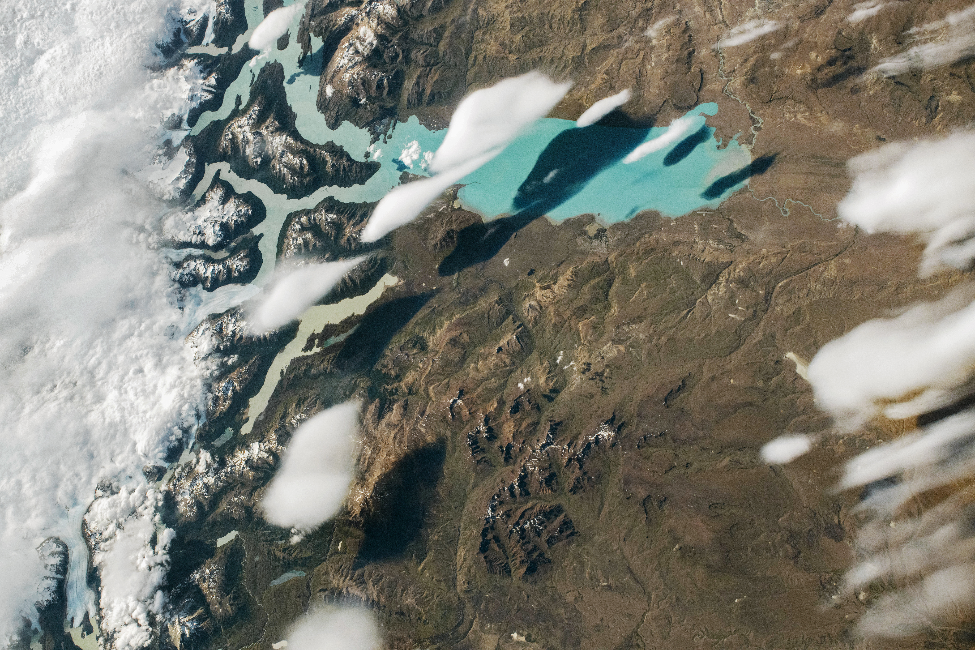
Clouds Swimming over Lago Argentino
- Image credit
- NASA / Expedition 74 crew; ISS Crew Earth Observations Facility and Earth Science and Remote Sensing Unit, NASA Johnson Space Center. Photograph ISS074-E-8940.
- Creator
- NASA / Expedition 74 crew; ISS Crew Earth Observations Facility and Earth Science and Remote Sensing Unit, NASA Johnson Space Center. Photograph ISS074-E-8940.
- Institution
- NASA
- What the image shows
- Real astronaut photograph; NASA’s published rendition was cropped and contrast-enhanced and had lens artifacts removed before our download.
- Observation date
- 2025-12-27
- Observation timing
- Published source gives the acquisition date but no clock time; no time inferred.
- Source publication date
- 2026-01-15
- Source publication
- Clouds Swimming over Lago Argentino
- Original image
- View the source image
- Reuse terms
- NASA-produced imagery is generally not subject to copyright in the United States. NASA Images and Media Usage Guidelines permit factual educational/informational reuse with acknowledgement and without implied endorsement; no separate third-party copyright restriction is marked on this asset.
- Reuse policy
- Read the reuse policy
- Changes made
- Downloaded NASA’s published JPEG, proportionally resized to a maximum 1600-pixel dimension and JPEG quality 82 with sips. Full source frame retained; no added labels, recoloring or generated content. Website thumbnails may crop responsively.
- Reuse scope
- NASA public-domain statement is specific to the United States. Its educational/informational reuse permission states no territorial restriction; no claim of worldwide public-domain status or NASA endorsement is made.
Katrina: a weaker wind category, a vast water threat — satellite imagery
- Image credit
- Jeff Schmaltz / NASA MODIS Land Rapid Response Team
- Creator
- Jeff Schmaltz / NASA MODIS Land Rapid Response Team
- Institution
- NASA Earth Science
- What the image shows
- Aqua MODIS shows Katrina’s cloud shield after the centre moved inland on 29 August 2005. The satellite passed over at 2:15 p.m. CDT.
- Observation date
- 2005-08-29
- Observation timing
- Acquisition timing is included in the caption where the source states it.
- Source publication date
- 2005-08-29
- Source publication
- Katrina: a weaker wind category, a vast water threat — satellite imagery
- Original image
- View the source image
- Reuse terms
- NASA Earth Science permits reuse of its published imagery where no separate copyright is indicated, with acknowledgement.
- Reuse policy
- Read the reuse policy
- Changes made
- Published scene proportionally resized when needed and saved as a JPEG.
- Reuse scope
- NASA Earth Science gives no geographic limit in its reuse statement. U.S. public-domain status is specific to the United States.

Sandy: a hurricane becomes a coastal giant — satellite imagery
- Image credit
- NASA EOSDIS GIBS/Worldview, Aqua MODIS
- Creator
- NASA EOSDIS GIBS/Worldview, Aqua MODIS
- Institution
- NASA Earth Science
- What the image shows
- Natural-color MODIS corrected reflectance. The image depicts conditions during the satellite’s daylight pass.
- Observation date
- 2012-10-29
- Observation timing
- The browse layer is indexed by UTC day. No exact overpass time is inferred.
- Source publication date
- Publication date not stated
- Source publication
- Sandy: a hurricane becomes a coastal giant — satellite imagery
- Original image
- View the source image
- Reuse terms
- NASA Earth Science permits reuse of its published imagery where no separate copyright is indicated, with acknowledgement.
- Reuse policy
- Read the reuse policy
- Changes made
- Regional archive frame saved as a JPEG.
- Reuse scope
- NASA Earth Science gives no geographic limit in its reuse statement. U.S. public-domain status is specific to the United States.
Maria: a changing eyewall across Caribbean islands — satellite imagery
- Image credit
- Joshua Stevens / NASA Earth Observatory, using NASA–NOAA GOES Project and LANCE/EOSDIS Rapid Response data
- Creator
- Joshua Stevens / NASA Earth Observatory, using NASA–NOAA GOES Project and LANCE/EOSDIS Rapid Response data
- Institution
- NASA Earth Science
- What the image shows
- Visible and infrared observations from GOES-13 at 10:15 UTC on 20 September 2017 show Maria over Puerto Rico. NASA combined them with regional imagery to make the composite.
- Observation date
- 2017-09-20
- Observation timing
- Acquisition timing is included in the caption where the source states it.
- Source publication date
- 2017-09-21
- Source publication
- Maria: a changing eyewall across Caribbean islands — satellite imagery
- Original image
- View the source image
- Reuse terms
- NASA Earth Science permits reuse of its published imagery where no separate copyright is indicated, with acknowledgement.
- Reuse policy
- Read the reuse policy
- Changes made
- Published scene proportionally resized when needed and saved as a JPEG.
- Reuse scope
- NASA Earth Science gives no geographic limit in its reuse statement. U.S. public-domain status is specific to the United States.

Florence: rainbands linger after the wind peak — satellite imagery
- Image credit
- NASA EOSDIS GIBS/Worldview, Aqua MODIS
- Creator
- NASA EOSDIS GIBS/Worldview, Aqua MODIS
- Institution
- NASA Earth Science
- What the image shows
- Natural-color MODIS corrected reflectance. The image depicts conditions during the satellite’s daylight pass.
- Observation date
- 2018-09-14
- Observation timing
- The browse layer is indexed by UTC day. No exact overpass time is inferred.
- Source publication date
- Publication date not stated
- Source publication
- Florence: rainbands linger after the wind peak — satellite imagery
- Original image
- View the source image
- Reuse terms
- NASA Earth Science permits reuse of its published imagery where no separate copyright is indicated, with acknowledgement.
- Reuse policy
- Read the reuse policy
- Changes made
- Regional archive frame saved as a JPEG.
- Reuse scope
- NASA Earth Science gives no geographic limit in its reuse statement. U.S. public-domain status is specific to the United States.
Dorian: intense rotation with almost no progress — satellite imagery
- Image credit
- Lauren Dauphin / NASA Earth Observatory, using NASA EOSDIS LANCE and GIBS/Worldview MODIS data
- Creator
- Lauren Dauphin / NASA Earth Observatory, using NASA EOSDIS LANCE and GIBS/Worldview MODIS data
- Institution
- NASA Earth Science
- What the image shows
- Aqua MODIS captured Dorian’s eye near Great Abaco at 18:05 UTC on 1 September 2019.
- Observation date
- 2019-09-01
- Observation timing
- Acquisition timing is included in the caption where the source states it.
- Source publication date
- 2019-09-01
- Source publication
- Dorian: intense rotation with almost no progress — satellite imagery
- Original image
- View the source image
- Reuse terms
- NASA Earth Science permits reuse of its published imagery where no separate copyright is indicated, with acknowledgement.
- Reuse policy
- Read the reuse policy
- Changes made
- Published scene proportionally resized when needed and saved as a JPEG.
- Reuse scope
- NASA Earth Science gives no geographic limit in its reuse statement. U.S. public-domain status is specific to the United States.

Ian: separate landfalls, separate coastal exposures — satellite imagery
- Image credit
- Joshua Stevens / NASA Earth Observatory, using USGS Landsat data
- Creator
- Joshua Stevens / NASA Earth Observatory, using USGS Landsat data
- Institution
- NASA Earth Science
- What the image shows
- Landsat 8 captured this natural-color view of Ian’s eye at 15:57 UTC on 28 September 2022, before it made landfall in southwest Florida.
- Observation date
- 2022-09-28
- Observation timing
- Acquisition timing is included in the caption where the source states it.
- Source publication date
- 2022-10-01
- Source publication
- Ian: separate landfalls, separate coastal exposures — satellite imagery
- Original image
- View the source image
- Reuse terms
- NASA Earth Science permits reuse of its published imagery where no separate copyright is indicated, with acknowledgement.
- Reuse policy
- Read the reuse policy
- Changes made
- Published scene proportionally resized when needed and saved as a JPEG.
- Reuse scope
- NASA Earth Science gives no geographic limit in its reuse statement. U.S. public-domain status is specific to the United States.

Otis: a short approach with extraordinary strengthening — satellite imagery
- Image credit
- Michala Garrison / NASA Earth Observatory, using VIIRS data from NASA EOSDIS LANCE, GIBS/Worldview and JPSS
- Creator
- Michala Garrison / NASA Earth Observatory, using VIIRS data from NASA EOSDIS LANCE, GIBS/Worldview and JPSS
- Institution
- NASA Earth Science
- What the image shows
- A false-color NOAA-20 VIIRS view at about 08:30 UTC on 24 October 2023 shows Otis offshore before its rapid intensification and landfall.
- Observation date
- 2023-10-24
- Observation timing
- Acquisition timing is included in the caption where the source states it.
- Source publication date
- 2023-10-26
- Source publication
- Otis: a short approach with extraordinary strengthening — satellite imagery
- Original image
- View the source image
- Reuse terms
- NASA Earth Science permits reuse of its published imagery where no separate copyright is indicated, with acknowledgement.
- Reuse policy
- Read the reuse policy
- Changes made
- Published scene proportionally resized when needed and saved as a JPEG.
- Reuse scope
- NASA Earth Science gives no geographic limit in its reuse statement. U.S. public-domain status is specific to the United States.

Freddy: a returning cyclone prolongs the rain — satellite imagery
- Image credit
- Lauren Dauphin / NASA Earth Observatory, using VIIRS data from NASA EOSDIS LANCE, GIBS/Worldview and JPSS
- Creator
- Lauren Dauphin / NASA Earth Observatory, using VIIRS data from NASA EOSDIS LANCE, GIBS/Worldview and JPSS
- Institution
- NASA Earth Science
- What the image shows
- NOAA-20 VIIRS captured Freddy just east of Madagascar at 10:50 UTC on 21 February 2023, hours before its first landfall.
- Observation date
- 2023-02-21
- Observation timing
- Acquisition timing is included in the caption where the source states it.
- Source publication date
- 2023-02-22
- Source publication
- Freddy: a returning cyclone prolongs the rain — satellite imagery
- Original image
- View the source image
- Reuse terms
- NASA Earth Science permits reuse of its published imagery where no separate copyright is indicated, with acknowledgement.
- Reuse policy
- Read the reuse policy
- Changes made
- Published scene proportionally resized when needed and saved as a JPEG.
- Reuse scope
- NASA Earth Science gives no geographic limit in its reuse statement. U.S. public-domain status is specific to the United States.

Winston: an island chain meets a changing track — satellite imagery
- Image credit
- NASA EOSDIS GIBS/Worldview, Aqua MODIS
- Creator
- NASA EOSDIS GIBS/Worldview, Aqua MODIS
- Institution
- NASA Earth Science
- What the image shows
- Natural-color MODIS corrected reflectance. The image depicts conditions during the satellite’s daylight pass.
- Observation date
- 2016-02-19
- Observation timing
- The browse layer is indexed by UTC day. No exact overpass time is inferred.
- Source publication date
- Publication date not stated
- Source publication
- Winston: an island chain meets a changing track — satellite imagery
- Original image
- View the source image
- Additional source image
- View source image 2
- Reuse terms
- NASA Earth Science permits reuse of its published imagery where no separate copyright is indicated, with acknowledgement.
- Reuse policy
- Read the reuse policy
- Changes made
- Joined the adjacent archive frames at the 180° meridian and saved as a JPEG.
- Reuse scope
- NASA Earth Science gives no geographic limit in its reuse statement. U.S. public-domain status is specific to the United States.
Yasi: pressure evidence beneath a large cyclone — satellite imagery
- Image credit
- Jeff Schmaltz / NASA MODIS Rapid Response Team
- Creator
- Jeff Schmaltz / NASA MODIS Rapid Response Team
- Institution
- NASA Earth Science
- What the image shows
- Aqua MODIS captured Yasi as it approached the Queensland coast at 03:35 UTC on 2 February 2011.
- Observation date
- 2011-02-02
- Observation timing
- Acquisition timing is included in the caption where the source states it.
- Source publication date
- 2011-02-02
- Source publication
- Yasi: pressure evidence beneath a large cyclone — satellite imagery
- Original image
- View the source image
- Reuse terms
- NASA Earth Science permits reuse of its published imagery where no separate copyright is indicated, with acknowledgement.
- Reuse policy
- Read the reuse policy
- Changes made
- Published scene proportionally resized when needed and saved as a JPEG.
- Reuse scope
- NASA Earth Science gives no geographic limit in its reuse statement. U.S. public-domain status is specific to the United States.

Tracy: a compact cyclone and a broken wind record — satellite imagery
- Image credit
- Reto Stöckli / NASA Earth Observatory, Blue Marble: Next Generation
- Creator
- Reto Stöckli / NASA Earth Observatory, Blue Marble: Next Generation
- Institution
- NASA Earth Science
- What the image shows
- Natural-color surface composite using cloud-screened satellite observations from July 2004.
- Observation date
- 2004-07
- Observation timing
- Monthly composite for July 2004.
- Source publication date
- 2005
- Source publication
- Tracy: a compact cyclone and a broken wind record — satellite imagery
- Original image
- View the source image
- Reuse terms
- NASA Earth Science permits reuse of its published imagery where no separate copyright is indicated, with acknowledgement.
- Reuse policy
- Read the reuse policy
- Changes made
- Cropped the regional view from the global composite, resized for display and saved as a JPEG.
- Reuse scope
- NASA Earth Science gives no geographic limit in its reuse statement. U.S. public-domain status is specific to the United States.

Daniel in Libya: rainfall, runoff and a cascading flood — satellite imagery
- Image credit
- Lauren Dauphin / NASA Earth Observatory, using USGS Landsat data
- Creator
- Lauren Dauphin / NASA Earth Observatory, using USGS Landsat data
- Institution
- NASA Earth Science
- What the image shows
- Landsat 9 captured eroded banks along Wadi Derna near the Mediterranean on 18 September 2023, a week after Storm Daniel.
- Observation date
- 2023-09-18
- Observation timing
- Acquisition timing is included in the caption where the source states it.
- Source publication date
- 2023-09-21
- Source publication
- Daniel in Libya: rainfall, runoff and a cascading flood — satellite imagery
- Original image
- View the source image
- Reuse terms
- NASA Earth Science permits reuse of its published imagery where no separate copyright is indicated, with acknowledgement.
- Reuse policy
- Read the reuse policy
- Changes made
- Published scene proportionally resized when needed and saved as a JPEG.
- Reuse scope
- NASA Earth Science gives no geographic limit in its reuse statement. U.S. public-domain status is specific to the United States.

Zhengzhou: an extreme hour within a longer rain event — satellite imagery
- Image credit
- NASA EOSDIS GIBS/Worldview, Aqua MODIS
- Creator
- NASA EOSDIS GIBS/Worldview, Aqua MODIS
- Institution
- NASA Earth Science
- What the image shows
- Natural-color MODIS corrected reflectance. The image depicts conditions during the satellite’s daylight pass.
- Observation date
- 2021-07-26
- Observation timing
- The browse layer is indexed by UTC day. No exact overpass time is inferred.
- Source publication date
- Publication date not stated
- Source publication
- Zhengzhou: an extreme hour within a longer rain event — satellite imagery
- Original image
- View the source image
- Reuse terms
- NASA Earth Science permits reuse of its published imagery where no separate copyright is indicated, with acknowledgement.
- Reuse policy
- Read the reuse policy
- Changes made
- Regional archive frame saved as a JPEG.
- Reuse scope
- NASA Earth Science gives no geographic limit in its reuse statement. U.S. public-domain status is specific to the United States.
Chennai: winter monsoon moisture meets a coastal low — satellite imagery
- Image credit
- NASA EOSDIS GIBS/Worldview, Aqua MODIS
- Creator
- NASA EOSDIS GIBS/Worldview, Aqua MODIS
- Institution
- NASA Earth Science
- What the image shows
- Natural-color MODIS corrected reflectance. The image depicts conditions during the satellite’s daylight pass.
- Observation date
- 2015-12-02
- Observation timing
- The browse layer is indexed by UTC day. No exact overpass time is inferred.
- Source publication date
- Publication date not stated
- Source publication
- Chennai: winter monsoon moisture meets a coastal low — satellite imagery
- Original image
- View the source image
- Reuse terms
- NASA Earth Science permits reuse of its published imagery where no separate copyright is indicated, with acknowledgement.
- Reuse policy
- Read the reuse policy
- Changes made
- Regional archive frame saved as a JPEG.
- Reuse scope
- NASA Earth Science gives no geographic limit in its reuse statement. U.S. public-domain status is specific to the United States.
Kerala: a wet monsoon season builds toward flooding — satellite imagery
- Image credit
- NASA EOSDIS GIBS/Worldview, Aqua MODIS
- Creator
- NASA EOSDIS GIBS/Worldview, Aqua MODIS
- Institution
- NASA Earth Science
- What the image shows
- Natural-color MODIS corrected reflectance. The image depicts conditions during the satellite’s daylight pass.
- Observation date
- 2018-08-22
- Observation timing
- The browse layer is indexed by UTC day. No exact overpass time is inferred.
- Source publication date
- Publication date not stated
- Source publication
- Kerala: a wet monsoon season builds toward flooding — satellite imagery
- Original image
- View the source image
- Reuse terms
- NASA Earth Science permits reuse of its published imagery where no separate copyright is indicated, with acknowledgement.
- Reuse policy
- Read the reuse policy
- Changes made
- Regional archive frame saved as a JPEG.
- Reuse scope
- NASA Earth Science gives no geographic limit in its reuse statement. U.S. public-domain status is specific to the United States.
The UAE deluge: intense rain on an arid landscape — satellite imagery
- Image credit
- Wanmei Liang / NASA Earth Observatory, using USGS Landsat data
- Creator
- Wanmei Liang / NASA Earth Observatory, using USGS Landsat data
- Institution
- NASA Earth Science
- What the image shows
- This Landsat 9 false-color scene shows water in blue around Jebel Ali on 19 April 2024, three days after the heaviest rain.
- Observation date
- 2024-04-19
- Observation timing
- Acquisition timing is included in the caption where the source states it.
- Source publication date
- 2024-04-20
- Source publication
- The UAE deluge: intense rain on an arid landscape — satellite imagery
- Original image
- View the source image
- Reuse terms
- NASA Earth Science permits reuse of its published imagery where no separate copyright is indicated, with acknowledgement.
- Reuse policy
- Read the reuse policy
- Changes made
- Published scene proportionally resized when needed and saved as a JPEG.
- Reuse scope
- NASA Earth Science gives no geographic limit in its reuse statement. U.S. public-domain status is specific to the United States.

Saharan dust over Europe: a plume is not a surface reading — satellite imagery
- Image credit
- NASA EOSDIS GIBS/Worldview, Aqua MODIS
- Creator
- NASA EOSDIS GIBS/Worldview, Aqua MODIS
- Institution
- NASA Earth Science
- What the image shows
- Natural-color MODIS corrected reflectance. The image depicts conditions during the satellite’s daylight pass.
- Observation date
- 2022-03-15
- Observation timing
- The browse layer is indexed by UTC day. No exact overpass time is inferred.
- Source publication date
- Publication date not stated
- Source publication
- Saharan dust over Europe: a plume is not a surface reading — satellite imagery
- Original image
- View the source image
- Reuse terms
- NASA Earth Science permits reuse of its published imagery where no separate copyright is indicated, with acknowledgement.
- Reuse policy
- Read the reuse policy
- Changes made
- Regional archive frame saved as a JPEG.
- Reuse scope
- NASA Earth Science gives no geographic limit in its reuse statement. U.S. public-domain status is specific to the United States.
The blizzard that lingered off New England — satellite imagery
- Image credit
- Reto Stöckli / NASA Earth Observatory, Blue Marble: Next Generation
- Creator
- Reto Stöckli / NASA Earth Observatory, Blue Marble: Next Generation
- Institution
- NASA Earth Science
- What the image shows
- Natural-color surface composite using cloud-screened satellite observations from July 2004.
- Observation date
- 2004-07
- Observation timing
- Monthly composite for July 2004.
- Source publication date
- 2005
- Source publication
- The blizzard that lingered off New England — satellite imagery
- Original image
- View the source image
- Reuse terms
- NASA Earth Science permits reuse of its published imagery where no separate copyright is indicated, with acknowledgement.
- Reuse policy
- Read the reuse policy
- Changes made
- Cropped the regional view from the global composite, resized for display and saved as a JPEG.
- Reuse scope
- NASA Earth Science gives no geographic limit in its reuse statement. U.S. public-domain status is specific to the United States.
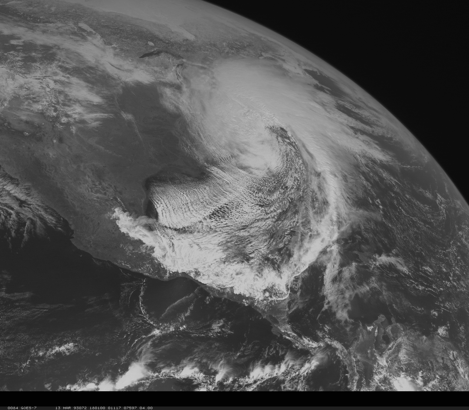
Snow reaches the Deep South in the 1993 superstorm — satellite imagery
- Image credit
- NOAA / National Weather Service State College
- Creator
- NOAA / National Weather Service State College
- Institution
- NOAA National Weather Service
- What the image shows
- GOES-7 visible imagery at 18:00 UTC on 13 March 1993 shows the cloud shield of the superstorm along the eastern United States.
- Observation date
- 1993-03-13
- Observation timing
- Acquisition timing is included in the caption where the source states it.
- Source publication date
- Not stated
- Source publication
- Snow reaches the Deep South in the 1993 superstorm — satellite imagery
- Original image
- View the source image
- Reuse terms
- NWS identifies this imagery as federal material available for lawful reuse with NOAA credited and no implied endorsement.
- Reuse policy
- Read the reuse policy
- Changes made
- Published scene proportionally resized when needed and saved as a JPEG.
- Reuse scope
- U.S. government public-domain statement. No geographic limit is stated for reuse under the NWS disclaimer.
Repeated freezing rain builds the 1998 Canadian ice storm — satellite imagery
- Image credit
- Reto Stöckli / NASA Earth Observatory, Blue Marble: Next Generation
- Creator
- Reto Stöckli / NASA Earth Observatory, Blue Marble: Next Generation
- Institution
- NASA Earth Science
- What the image shows
- Natural-color surface composite using cloud-screened satellite observations from July 2004.
- Observation date
- 2004-07
- Observation timing
- Monthly composite for July 2004.
- Source publication date
- 2005
- Source publication
- Repeated freezing rain builds the 1998 Canadian ice storm — satellite imagery
- Original image
- View the source image
- Reuse terms
- NASA Earth Science permits reuse of its published imagery where no separate copyright is indicated, with acknowledgement.
- Reuse policy
- Read the reuse policy
- Changes made
- Cropped the regional view from the global composite, resized for display and saved as a JPEG.
- Reuse scope
- NASA Earth Science gives no geographic limit in its reuse statement. U.S. public-domain status is specific to the United States.
Why the winter of 1963 refused to thaw — satellite imagery
- Image credit
- Reto Stöckli / NASA Earth Observatory, Blue Marble: Next Generation
- Creator
- Reto Stöckli / NASA Earth Observatory, Blue Marble: Next Generation
- Institution
- NASA Earth Science
- What the image shows
- Natural-color surface composite using cloud-screened satellite observations from July 2004.
- Observation date
- 2004-07
- Observation timing
- Monthly composite for July 2004.
- Source publication date
- 2005
- Source publication
- Why the winter of 1963 refused to thaw — satellite imagery
- Original image
- View the source image
- Reuse terms
- NASA Earth Science permits reuse of its published imagery where no separate copyright is indicated, with acknowledgement.
- Reuse policy
- Read the reuse policy
- Changes made
- Cropped the regional view from the global composite, resized for display and saved as a JPEG.
- Reuse scope
- NASA Earth Science gives no geographic limit in its reuse statement. U.S. public-domain status is specific to the United States.
A blocking high redirects Europe’s winter air — satellite imagery
- Image credit
- NASA EOSDIS GIBS/Worldview, Aqua MODIS
- Creator
- NASA EOSDIS GIBS/Worldview, Aqua MODIS
- Institution
- NASA Earth Science
- What the image shows
- Natural-color MODIS corrected reflectance. The image depicts conditions during the satellite’s daylight pass.
- Observation date
- 2012-02-03
- Observation timing
- The browse layer is indexed by UTC day. No exact overpass time is inferred.
- Source publication date
- Publication date not stated
- Source publication
- A blocking high redirects Europe’s winter air — satellite imagery
- Original image
- View the source image
- Reuse terms
- NASA Earth Science permits reuse of its published imagery where no separate copyright is indicated, with acknowledgement.
- Reuse policy
- Read the reuse policy
- Changes made
- Regional archive frame saved as a JPEG.
- Reuse scope
- NASA Earth Science gives no geographic limit in its reuse statement. U.S. public-domain status is specific to the United States.
Illinois measures the January 2019 Arctic outbreak — satellite imagery
- Image credit
- NASA EOSDIS GIBS/Worldview, Aqua MODIS
- Creator
- NASA EOSDIS GIBS/Worldview, Aqua MODIS
- Institution
- NASA Earth Science
- What the image shows
- Natural-color MODIS corrected reflectance. The image depicts conditions during the satellite’s daylight pass.
- Observation date
- 2019-01-30
- Observation timing
- The browse layer is indexed by UTC day. No exact overpass time is inferred.
- Source publication date
- Publication date not stated
- Source publication
- Illinois measures the January 2019 Arctic outbreak — satellite imagery
- Original image
- View the source image
- Reuse terms
- NASA Earth Science permits reuse of its published imagery where no separate copyright is indicated, with acknowledgement.
- Reuse policy
- Read the reuse policy
- Changes made
- Regional archive frame saved as a JPEG.
- Reuse scope
- NASA Earth Science gives no geographic limit in its reuse statement. U.S. public-domain status is specific to the United States.
Filomena lays snow over Spain’s cold interior — satellite imagery
- Image credit
- Lauren Dauphin / NASA Earth Observatory, using NASA EOSDIS LANCE and GIBS/Worldview MODIS data
- Creator
- Lauren Dauphin / NASA Earth Observatory, using NASA EOSDIS LANCE and GIBS/Worldview MODIS data
- Institution
- NASA Earth Science
- What the image shows
- An Aqua MODIS image from 11 January 2021 shows snow cover over central Spain in teal and much of the cloud cover in white.
- Observation date
- 2021-01-11
- Observation timing
- Acquisition timing is included in the caption where the source states it.
- Source publication date
- 2021-01-12
- Source publication
- Filomena lays snow over Spain’s cold interior — satellite imagery
- Original image
- View the source image
- Reuse terms
- NASA Earth Science permits reuse of its published imagery where no separate copyright is indicated, with acknowledgement.
- Reuse policy
- Read the reuse policy
- Changes made
- Published scene proportionally resized when needed and saved as a JPEG.
- Reuse scope
- NASA Earth Science gives no geographic limit in its reuse statement. U.S. public-domain status is specific to the United States.

Chicago’s 1995 heat stayed through the night — satellite imagery
- Image credit
- Reto Stöckli / NASA Earth Observatory, Blue Marble: Next Generation
- Creator
- Reto Stöckli / NASA Earth Observatory, Blue Marble: Next Generation
- Institution
- NASA Earth Science
- What the image shows
- Natural-color surface composite using cloud-screened satellite observations from July 2004.
- Observation date
- 2004-07
- Observation timing
- Monthly composite for July 2004.
- Source publication date
- 2005
- Source publication
- Chicago’s 1995 heat stayed through the night — satellite imagery
- Original image
- View the source image
- Reuse terms
- NASA Earth Science permits reuse of its published imagery where no separate copyright is indicated, with acknowledgement.
- Reuse policy
- Read the reuse policy
- Changes made
- Cropped the regional view from the global composite, resized for display and saved as a JPEG.
- Reuse scope
- NASA Earth Science gives no geographic limit in its reuse statement. U.S. public-domain status is specific to the United States.
Different records trace Europe’s August 2003 heat — satellite imagery
- Image credit
- NASA EOSDIS GIBS/Worldview, Aqua MODIS
- Creator
- NASA EOSDIS GIBS/Worldview, Aqua MODIS
- Institution
- NASA Earth Science
- What the image shows
- Natural-color MODIS corrected reflectance. The image depicts conditions during the satellite’s daylight pass.
- Observation date
- 2003-08-10
- Observation timing
- The browse layer is indexed by UTC day. No exact overpass time is inferred.
- Source publication date
- Publication date not stated
- Source publication
- Different records trace Europe’s August 2003 heat — satellite imagery
- Original image
- View the source image
- Reuse terms
- NASA Earth Science permits reuse of its published imagery where no separate copyright is indicated, with acknowledgement.
- Reuse policy
- Read the reuse policy
- Changes made
- Regional archive frame saved as a JPEG.
- Reuse scope
- NASA Earth Science gives no geographic limit in its reuse statement. U.S. public-domain status is specific to the United States.
France’s June 2019 heat crosses 46°C — satellite imagery
- Image credit
- NASA EOSDIS GIBS/Worldview, Aqua MODIS
- Creator
- NASA EOSDIS GIBS/Worldview, Aqua MODIS
- Institution
- NASA Earth Science
- What the image shows
- Natural-color MODIS corrected reflectance. The image depicts conditions during the satellite’s daylight pass.
- Observation date
- 2019-06-28
- Observation timing
- The browse layer is indexed by UTC day. No exact overpass time is inferred.
- Source publication date
- Publication date not stated
- Source publication
- France’s June 2019 heat crosses 46°C — satellite imagery
- Original image
- View the source image
- Reuse terms
- NASA Earth Science permits reuse of its published imagery where no separate copyright is indicated, with acknowledgement.
- Reuse policy
- Read the reuse policy
- Changes made
- Regional archive frame saved as a JPEG.
- Reuse scope
- NASA Earth Science gives no geographic limit in its reuse statement. U.S. public-domain status is specific to the United States.
Australia’s January 2013 heat spreads across the continent — satellite imagery
- Image credit
- Reto Stöckli / NASA Earth Observatory, Blue Marble: Next Generation
- Creator
- Reto Stöckli / NASA Earth Observatory, Blue Marble: Next Generation
- Institution
- NASA Earth Science
- What the image shows
- Natural-color surface composite using cloud-screened satellite observations from July 2004.
- Observation date
- 2004-07
- Observation timing
- Monthly composite for July 2004.
- Source publication date
- 2005
- Source publication
- Australia’s January 2013 heat spreads across the continent — satellite imagery
- Original image
- View the source image
- Reuse terms
- NASA Earth Science permits reuse of its published imagery where no separate copyright is indicated, with acknowledgement.
- Reuse policy
- Read the reuse policy
- Changes made
- Cropped the regional view from the global composite, resized for display and saved as a JPEG.
- Reuse scope
- NASA Earth Science gives no geographic limit in its reuse statement. U.S. public-domain status is specific to the United States.
Verkhoyansk’s 38°C reading becomes a verified Arctic record — satellite imagery
- Image credit
- NASA EOSDIS GIBS/Worldview, Aqua MODIS
- Creator
- NASA EOSDIS GIBS/Worldview, Aqua MODIS
- Institution
- NASA Earth Science
- What the image shows
- Natural-color MODIS corrected reflectance. The image depicts conditions during the satellite’s daylight pass.
- Observation date
- 2020-06-20
- Observation timing
- The browse layer is indexed by UTC day. No exact overpass time is inferred.
- Source publication date
- Publication date not stated
- Source publication
- Verkhoyansk’s 38°C reading becomes a verified Arctic record — satellite imagery
- Original image
- View the source image
- Reuse terms
- NASA Earth Science permits reuse of its published imagery where no separate copyright is indicated, with acknowledgement.
- Reuse policy
- Read the reuse policy
- Changes made
- Regional archive frame saved as a JPEG.
- Reuse scope
- NASA Earth Science gives no geographic limit in its reuse statement. U.S. public-domain status is specific to the United States.
Vostok’s record cold follows prolonged isolation — satellite imagery
- Image credit
- Reto Stöckli / NASA Earth Observatory, Blue Marble: Next Generation
- Creator
- Reto Stöckli / NASA Earth Observatory, Blue Marble: Next Generation
- Institution
- NASA Earth Science
- What the image shows
- Natural-color surface composite using cloud-screened satellite observations from July 2004.
- Observation date
- 2004-07
- Observation timing
- Monthly composite for July 2004.
- Source publication date
- 2005
- Source publication
- Vostok’s record cold follows prolonged isolation — satellite imagery
- Original image
- View the source image
- Reuse terms
- NASA Earth Science permits reuse of its published imagery where no separate copyright is indicated, with acknowledgement.
- Reuse policy
- Read the reuse policy
- Changes made
- Cropped the regional view from the global composite, resized for display and saved as a JPEG.
- Reuse scope
- NASA Earth Science gives no geographic limit in its reuse statement. U.S. public-domain status is specific to the United States.
Rain reaches Greenland’s Summit Station — satellite imagery
- Image credit
- NASA EOSDIS GIBS/Worldview, Aqua MODIS
- Creator
- NASA EOSDIS GIBS/Worldview, Aqua MODIS
- Institution
- NASA Earth Science
- What the image shows
- Natural-color MODIS corrected reflectance. The image depicts conditions during the satellite’s daylight pass.
- Observation date
- 2021-08-14
- Observation timing
- The browse layer is indexed by UTC day. No exact overpass time is inferred.
- Source publication date
- Publication date not stated
- Source publication
- Rain reaches Greenland’s Summit Station — satellite imagery
- Original image
- View the source image
- Reuse terms
- NASA Earth Science permits reuse of its published imagery where no separate copyright is indicated, with acknowledgement.
- Reuse policy
- Read the reuse policy
- Changes made
- Regional archive frame saved as a JPEG.
- Reuse scope
- NASA Earth Science gives no geographic limit in its reuse statement. U.S. public-domain status is specific to the United States.
Boulder’s January 1982 downslope windstorm — satellite imagery
- Image credit
- Reto Stöckli / NASA Earth Observatory, Blue Marble: Next Generation
- Creator
- Reto Stöckli / NASA Earth Observatory, Blue Marble: Next Generation
- Institution
- NASA Earth Science
- What the image shows
- Natural-color surface composite using cloud-screened satellite observations from July 2004.
- Observation date
- 2004-07
- Observation timing
- Monthly composite for July 2004.
- Source publication date
- 2005
- Source publication
- Boulder’s January 1982 downslope windstorm — satellite imagery
- Original image
- View the source image
- Reuse terms
- NASA Earth Science permits reuse of its published imagery where no separate copyright is indicated, with acknowledgement.
- Reuse policy
- Read the reuse policy
- Changes made
- Cropped the regional view from the global composite, resized for display and saved as a JPEG.
- Reuse scope
- NASA Earth Science gives no geographic limit in its reuse statement. U.S. public-domain status is specific to the United States.
How observers measured Mount Washington’s great gust — satellite imagery
- Image credit
- Reto Stöckli / NASA Earth Observatory, Blue Marble: Next Generation
- Creator
- Reto Stöckli / NASA Earth Observatory, Blue Marble: Next Generation
- Institution
- NASA Earth Science
- What the image shows
- Natural-color surface composite using cloud-screened satellite observations from July 2004.
- Observation date
- 2004-07
- Observation timing
- Monthly composite for July 2004.
- Source publication date
- 2005
- Source publication
- How observers measured Mount Washington’s great gust — satellite imagery
- Original image
- View the source image
- Reuse terms
- NASA Earth Science permits reuse of its published imagery where no separate copyright is indicated, with acknowledgement.
- Reuse policy
- Read the reuse policy
- Changes made
- Cropped the regional view from the global composite, resized for display and saved as a JPEG.
- Reuse scope
- NASA Earth Science gives no geographic limit in its reuse statement. U.S. public-domain status is specific to the United States.
Two satellites reveal the edges of California’s Tule fog — satellite imagery
- Image credit
- NASA EOSDIS GIBS/Worldview, Aqua MODIS
- Creator
- NASA EOSDIS GIBS/Worldview, Aqua MODIS
- Institution
- NASA Earth Science
- What the image shows
- Natural-color MODIS corrected reflectance. The image depicts conditions during the satellite’s daylight pass.
- Observation date
- 2011-01-05
- Observation timing
- The browse layer is indexed by UTC day. No exact overpass time is inferred.
- Source publication date
- Publication date not stated
- Source publication
- Two satellites reveal the edges of California’s Tule fog — satellite imagery
- Original image
- View the source image
- Reuse terms
- NASA Earth Science permits reuse of its published imagery where no separate copyright is indicated, with acknowledgement.
- Reuse policy
- Read the reuse policy
- Changes made
- Regional archive frame saved as a JPEG.
- Reuse scope
- NASA Earth Science gives no geographic limit in its reuse statement. U.S. public-domain status is specific to the United States.
1974: many tornadoes inside one large weather system — satellite imagery
- Image credit
- Reto Stöckli / NASA Earth Observatory, Blue Marble: Next Generation
- Creator
- Reto Stöckli / NASA Earth Observatory, Blue Marble: Next Generation
- Institution
- NASA Earth Science
- What the image shows
- Natural-color surface composite using cloud-screened satellite observations from July 2004.
- Observation date
- 2004-07
- Observation timing
- Monthly composite for July 2004.
- Source publication date
- 2005
- Source publication
- 1974: many tornadoes inside one large weather system — satellite imagery
- Original image
- View the source image
- Reuse terms
- NASA Earth Science permits reuse of its published imagery where no separate copyright is indicated, with acknowledgement.
- Reuse policy
- Read the reuse policy
- Changes made
- Cropped the regional view from the global composite, resized for display and saved as a JPEG.
- Reuse scope
- NASA Earth Science gives no geographic limit in its reuse statement. U.S. public-domain status is specific to the United States.
April 2011: the danger returned in successive waves — satellite imagery
- Image credit
- NASA EOSDIS GIBS/Worldview, Aqua MODIS
- Creator
- NASA EOSDIS GIBS/Worldview, Aqua MODIS
- Institution
- NASA Earth Science
- What the image shows
- Natural-color MODIS corrected reflectance. The image depicts conditions during the satellite’s daylight pass.
- Observation date
- 2011-04-27
- Observation timing
- The browse layer is indexed by UTC day. No exact overpass time is inferred.
- Source publication date
- Publication date not stated
- Source publication
- April 2011: the danger returned in successive waves — satellite imagery
- Original image
- View the source image
- Reuse terms
- NASA Earth Science permits reuse of its published imagery where no separate copyright is indicated, with acknowledgement.
- Reuse policy
- Read the reuse policy
- Changes made
- Regional archive frame saved as a JPEG.
- Reuse scope
- NASA Earth Science gives no geographic limit in its reuse statement. U.S. public-domain status is specific to the United States.
Joplin: a rapid transition from storm to urban disaster — satellite imagery
- Image credit
- Jesse Allen and Robert Simmon / NASA Earth Observatory, using U.S./Japan ASTER Science Team data
- Creator
- Jesse Allen and Robert Simmon / NASA Earth Observatory, using U.S./Japan ASTER Science Team data
- Institution
- NASA Earth Science
- What the image shows
- A false-color Terra ASTER image from 30 May 2011 shows Joplin’s tornado damage path as a pale strip through the city eight days after the storm.
- Observation date
- 2011-05-30
- Observation timing
- Acquisition timing is included in the caption where the source states it.
- Source publication date
- 2011-06-01
- Source publication
- Joplin: a rapid transition from storm to urban disaster — satellite imagery
- Original image
- View the source image
- Reuse terms
- NASA Earth Science permits reuse of its published imagery where no separate copyright is indicated, with acknowledgement.
- Reuse policy
- Read the reuse policy
- Changes made
- Published scene proportionally resized when needed and saved as a JPEG.
- Reuse scope
- NASA Earth Science gives no geographic limit in its reuse statement. U.S. public-domain status is specific to the United States.

Moore: initiation along a dryline, then rapid intensification — satellite imagery
- Image credit
- NASA EOSDIS GIBS/Worldview, Aqua MODIS
- Creator
- NASA EOSDIS GIBS/Worldview, Aqua MODIS
- Institution
- NASA Earth Science
- What the image shows
- Natural-color MODIS corrected reflectance. The image depicts conditions during the satellite’s daylight pass.
- Observation date
- 2013-05-20
- Observation timing
- The browse layer is indexed by UTC day. No exact overpass time is inferred.
- Source publication date
- Publication date not stated
- Source publication
- Moore: initiation along a dryline, then rapid intensification — satellite imagery
- Original image
- View the source image
- Reuse terms
- NASA Earth Science permits reuse of its published imagery where no separate copyright is indicated, with acknowledgement.
- Reuse policy
- Read the reuse policy
- Changes made
- Regional archive frame saved as a JPEG.
- Reuse scope
- NASA Earth Science gives no geographic limit in its reuse statement. U.S. public-domain status is specific to the United States.
El Reno: a changing tornado, followed by training rain — satellite imagery
- Image credit
- NASA EOSDIS GIBS/Worldview, Aqua MODIS
- Creator
- NASA EOSDIS GIBS/Worldview, Aqua MODIS
- Institution
- NASA Earth Science
- What the image shows
- Natural-color MODIS corrected reflectance. The image depicts conditions during the satellite’s daylight pass.
- Observation date
- 2013-05-31
- Observation timing
- The browse layer is indexed by UTC day. No exact overpass time is inferred.
- Source publication date
- Publication date not stated
- Source publication
- El Reno: a changing tornado, followed by training rain — satellite imagery
- Original image
- View the source image
- Reuse terms
- NASA Earth Science permits reuse of its published imagery where no separate copyright is indicated, with acknowledgement.
- Reuse policy
- Read the reuse policy
- Changes made
- Regional archive frame saved as a JPEG.
- Reuse scope
- NASA Earth Science gives no geographic limit in its reuse statement. U.S. public-domain status is specific to the United States.
Greensburg: a violent tornado after sunset — satellite imagery
- Image credit
- NASA EOSDIS GIBS/Worldview, Aqua MODIS
- Creator
- NASA EOSDIS GIBS/Worldview, Aqua MODIS
- Institution
- NASA Earth Science
- What the image shows
- Natural-color MODIS corrected reflectance. The image depicts conditions during the satellite’s daylight pass.
- Observation date
- 2007-05-04
- Observation timing
- The browse layer is indexed by UTC day. No exact overpass time is inferred.
- Source publication date
- Publication date not stated
- Source publication
- Greensburg: a violent tornado after sunset — satellite imagery
- Original image
- View the source image
- Reuse terms
- NASA Earth Science permits reuse of its published imagery where no separate copyright is indicated, with acknowledgement.
- Reuse policy
- Read the reuse policy
- Changes made
- Regional archive frame saved as a JPEG.
- Reuse scope
- NASA Earth Science gives no geographic limit in its reuse statement. U.S. public-domain status is specific to the United States.
Western Kentucky: a long-track tornado in December — satellite imagery
- Image credit
- NASA EOSDIS GIBS/Worldview, Aqua MODIS
- Creator
- NASA EOSDIS GIBS/Worldview, Aqua MODIS
- Institution
- NASA Earth Science
- What the image shows
- Natural-color MODIS corrected reflectance. The image depicts conditions during the satellite’s daylight pass.
- Observation date
- 2021-12-10
- Observation timing
- The browse layer is indexed by UTC day. No exact overpass time is inferred.
- Source publication date
- Publication date not stated
- Source publication
- Western Kentucky: a long-track tornado in December — satellite imagery
- Original image
- View the source image
- Reuse terms
- NASA Earth Science permits reuse of its published imagery where no separate copyright is indicated, with acknowledgement.
- Reuse policy
- Read the reuse policy
- Changes made
- Regional archive frame saved as a JPEG.
- Reuse scope
- NASA Earth Science gives no geographic limit in its reuse statement. U.S. public-domain status is specific to the United States.
Rolling Fork: the survey improved after the storm ended — satellite imagery
- Image credit
- NASA EOSDIS GIBS/Worldview, Aqua MODIS
- Creator
- NASA EOSDIS GIBS/Worldview, Aqua MODIS
- Institution
- NASA Earth Science
- What the image shows
- Natural-color MODIS corrected reflectance. The image depicts conditions during the satellite’s daylight pass.
- Observation date
- 2023-03-24
- Observation timing
- The browse layer is indexed by UTC day. No exact overpass time is inferred.
- Source publication date
- Publication date not stated
- Source publication
- Rolling Fork: the survey improved after the storm ended — satellite imagery
- Original image
- View the source image
- Reuse terms
- NASA Earth Science permits reuse of its published imagery where no separate copyright is indicated, with acknowledgement.
- Reuse policy
- Read the reuse policy
- Changes made
- Regional archive frame saved as a JPEG.
- Reuse scope
- NASA Earth Science gives no geographic limit in its reuse statement. U.S. public-domain status is specific to the United States.
Iowa’s derecho: a broad wind swath, not a giant tornado — satellite imagery
- Image credit
- NASA EOSDIS GIBS/Worldview, Aqua MODIS
- Creator
- NASA EOSDIS GIBS/Worldview, Aqua MODIS
- Institution
- NASA Earth Science
- What the image shows
- Natural-color MODIS corrected reflectance. The image depicts conditions during the satellite’s daylight pass.
- Observation date
- 2020-08-10
- Observation timing
- The browse layer is indexed by UTC day. No exact overpass time is inferred.
- Source publication date
- Publication date not stated
- Source publication
- Iowa’s derecho: a broad wind swath, not a giant tornado — satellite imagery
- Original image
- View the source image
- Reuse terms
- NASA Earth Science permits reuse of its published imagery where no separate copyright is indicated, with acknowledgement.
- Reuse policy
- Read the reuse policy
- Changes made
- Regional archive frame saved as a JPEG.
- Reuse scope
- NASA Earth Science gives no geographic limit in its reuse statement. U.S. public-domain status is specific to the United States.
December 2021: thunderstorm winds and background winds overlapped — satellite imagery
- Image credit
- NASA EOSDIS GIBS/Worldview, Aqua MODIS
- Creator
- NASA EOSDIS GIBS/Worldview, Aqua MODIS
- Institution
- NASA Earth Science
- What the image shows
- Natural-color MODIS corrected reflectance. The image depicts conditions during the satellite’s daylight pass.
- Observation date
- 2021-12-15
- Observation timing
- The browse layer is indexed by UTC day. No exact overpass time is inferred.
- Source publication date
- Publication date not stated
- Source publication
- December 2021: thunderstorm winds and background winds overlapped — satellite imagery
- Original image
- View the source image
- Reuse terms
- NASA Earth Science permits reuse of its published imagery where no separate copyright is indicated, with acknowledgement.
- Reuse policy
- Read the reuse policy
- Changes made
- Regional archive frame saved as a JPEG.
- Reuse scope
- NASA Earth Science gives no geographic limit in its reuse statement. U.S. public-domain status is specific to the United States.
The 2012 derecho: storms follow the edge of a heat wave — satellite imagery
- Image credit
- NASA EOSDIS GIBS/Worldview, Aqua MODIS
- Creator
- NASA EOSDIS GIBS/Worldview, Aqua MODIS
- Institution
- NASA Earth Science
- What the image shows
- Natural-color MODIS corrected reflectance. The image depicts conditions during the satellite’s daylight pass.
- Observation date
- 2012-06-29
- Observation timing
- The browse layer is indexed by UTC day. No exact overpass time is inferred.
- Source publication date
- Publication date not stated
- Source publication
- The 2012 derecho: storms follow the edge of a heat wave — satellite imagery
- Original image
- View the source image
- Reuse terms
- NASA Earth Science permits reuse of its published imagery where no separate copyright is indicated, with acknowledgement.
- Reuse policy
- Read the reuse policy
- Changes made
- Regional archive frame saved as a JPEG.
- Reuse scope
- NASA Earth Science gives no geographic limit in its reuse statement. U.S. public-domain status is specific to the United States.
Vivian: measuring a hailstone before it disappears — satellite imagery
- Image credit
- NASA EOSDIS GIBS/Worldview, Aqua MODIS
- Creator
- NASA EOSDIS GIBS/Worldview, Aqua MODIS
- Institution
- NASA Earth Science
- What the image shows
- Natural-color MODIS corrected reflectance. The image depicts conditions during the satellite’s daylight pass.
- Observation date
- 2010-07-23
- Observation timing
- The browse layer is indexed by UTC day. No exact overpass time is inferred.
- Source publication date
- Publication date not stated
- Source publication
- Vivian: measuring a hailstone before it disappears — satellite imagery
- Original image
- View the source image
- Reuse terms
- NASA Earth Science permits reuse of its published imagery where no separate copyright is indicated, with acknowledgement.
- Reuse policy
- Read the reuse policy
- Changes made
- Regional archive frame saved as a JPEG.
- Reuse scope
- NASA Earth Science gives no geographic limit in its reuse statement. U.S. public-domain status is specific to the United States.
Denver hail: cloud-top detail is not a hail-size measurement — satellite imagery
- Image credit
- NASA EOSDIS GIBS/Worldview, Aqua MODIS
- Creator
- NASA EOSDIS GIBS/Worldview, Aqua MODIS
- Institution
- NASA Earth Science
- What the image shows
- Natural-color MODIS corrected reflectance. The image depicts conditions during the satellite’s daylight pass.
- Observation date
- 2017-05-08
- Observation timing
- The browse layer is indexed by UTC day. No exact overpass time is inferred.
- Source publication date
- Publication date not stated
- Source publication
- Denver hail: cloud-top detail is not a hail-size measurement — satellite imagery
- Original image
- View the source image
- Reuse terms
- NASA Earth Science permits reuse of its published imagery where no separate copyright is indicated, with acknowledgement.
- Reuse policy
- Read the reuse policy
- Changes made
- Regional archive frame saved as a JPEG.
- Reuse scope
- NASA Earth Science gives no geographic limit in its reuse statement. U.S. public-domain status is specific to the United States.
Fort Collins: small rainfall distances, large flood differences — satellite imagery
- Image credit
- Reto Stöckli / NASA Earth Observatory, Blue Marble: Next Generation
- Creator
- Reto Stöckli / NASA Earth Observatory, Blue Marble: Next Generation
- Institution
- NASA Earth Science
- What the image shows
- Natural-color surface composite using cloud-screened satellite observations from July 2004.
- Observation date
- 2004-07
- Observation timing
- Monthly composite for July 2004.
- Source publication date
- 2005
- Source publication
- Fort Collins: small rainfall distances, large flood differences — satellite imagery
- Original image
- View the source image
- Reuse terms
- NASA Earth Science permits reuse of its published imagery where no separate copyright is indicated, with acknowledgement.
- Reuse policy
- Read the reuse policy
- Changes made
- Cropped the regional view from the global composite, resized for display and saved as a JPEG.
- Reuse scope
- NASA Earth Science gives no geographic limit in its reuse statement. U.S. public-domain status is specific to the United States.
Big Thompson: the storm barely moved, the water moved fast — satellite imagery
- Image credit
- Reto Stöckli / NASA Earth Observatory, Blue Marble: Next Generation
- Creator
- Reto Stöckli / NASA Earth Observatory, Blue Marble: Next Generation
- Institution
- NASA Earth Science
- What the image shows
- Natural-color surface composite using cloud-screened satellite observations from July 2004.
- Observation date
- 2004-07
- Observation timing
- Monthly composite for July 2004.
- Source publication date
- 2005
- Source publication
- Big Thompson: the storm barely moved, the water moved fast — satellite imagery
- Original image
- View the source image
- Reuse terms
- NASA Earth Science permits reuse of its published imagery where no separate copyright is indicated, with acknowledgement.
- Reuse policy
- Read the reuse policy
- Changes made
- Cropped the regional view from the global composite, resized for display and saved as a JPEG.
- Reuse scope
- NASA Earth Science gives no geographic limit in its reuse statement. U.S. public-domain status is specific to the United States.
South Moravia: rebuilding a tornado track from many kinds of evidence — satellite imagery
- Image credit
- NASA EOSDIS GIBS/Worldview, Aqua MODIS
- Creator
- NASA EOSDIS GIBS/Worldview, Aqua MODIS
- Institution
- NASA Earth Science
- What the image shows
- Natural-color MODIS corrected reflectance. The image depicts conditions during the satellite’s daylight pass.
- Observation date
- 2021-06-24
- Observation timing
- The browse layer is indexed by UTC day. No exact overpass time is inferred.
- Source publication date
- Publication date not stated
- Source publication
- South Moravia: rebuilding a tornado track from many kinds of evidence — satellite imagery
- Original image
- View the source image
- Reuse terms
- NASA Earth Science permits reuse of its published imagery where no separate copyright is indicated, with acknowledgement.
- Reuse policy
- Read the reuse policy
- Changes made
- Regional archive frame saved as a JPEG.
- Reuse scope
- NASA Earth Science gives no geographic limit in its reuse statement. U.S. public-domain status is specific to the United States.
May 1999: one weather system, many separate tornadoes — satellite imagery
- Image credit
- Reto Stöckli / NASA Earth Observatory, Blue Marble: Next Generation
- Creator
- Reto Stöckli / NASA Earth Observatory, Blue Marble: Next Generation
- Institution
- NASA Earth Science
- What the image shows
- Natural-color surface composite using cloud-screened satellite observations from July 2004.
- Observation date
- 2004-07
- Observation timing
- Monthly composite for July 2004.
- Source publication date
- 2005
- Source publication
- May 1999: one weather system, many separate tornadoes — satellite imagery
- Original image
- View the source image
- Reuse terms
- NASA Earth Science permits reuse of its published imagery where no separate copyright is indicated, with acknowledgement.
- Reuse policy
- Read the reuse policy
- Changes made
- Cropped the regional view from the global composite, resized for display and saved as a JPEG.
- Reuse scope
- NASA Earth Science gives no geographic limit in its reuse statement. U.S. public-domain status is specific to the United States.
195 entries
topicThe atmosphere has layers+
- Layers of the Atmosphere
NOAA / National Weather Service · Publication date not stated
Reference only; original paraphrase; no source media reproduced. JetStream permits broad use of its materials; separate credits are not assumed cleared. - Parcel Theory
NOAA / National Weather Service · Publication date not stated
Reference only; original paraphrase; no source media reproduced. JetStream permits broad use of its materials; separate credits are not assumed cleared.
topicWhere the day’s warmth goes+
- The Transfer of Heat Energy
NOAA / National Weather Service · Publication date not stated
Reference only; original paraphrase; no source media reproduced. JetStream permits broad use of its materials; separate credits are not assumed cleared. - The Earth-Atmosphere Energy Balance
NOAA / National Weather Service · Publication date not stated
Reference only; original paraphrase; no source media reproduced. JetStream permits broad use of its materials; separate credits are not assumed cleared. - The Hydrologic Cycle
NOAA / National Weather Service · Publication date not stated
Reference only; original paraphrase; no source media reproduced. JetStream permits broad use of its materials; separate credits are not assumed cleared.
topicThe atmosphere exchanges infrared energy+
- The Earth-Atmosphere Energy Balance
NOAA / National Weather Service · Publication date not stated
Reference only; original paraphrase; no source media reproduced. JetStream permits broad use of its materials; separate credits are not assumed cleared. - Layers of the Atmosphere
NOAA / National Weather Service · Publication date not stated
Reference only; original paraphrase; no source media reproduced. JetStream permits broad use of its materials; separate credits are not assumed cleared.
topicWhy the warmest hour comes later+
- The Earth-Atmosphere Energy Balance
NOAA / National Weather Service · Publication date not stated
Reference only; original paraphrase; no source media reproduced. JetStream permits broad use of its materials; separate credits are not assumed cleared. - The Transfer of Heat Energy
NOAA / National Weather Service · Publication date not stated
Reference only; original paraphrase; no source media reproduced. JetStream permits broad use of its materials; separate credits are not assumed cleared. - Air Masses
NOAA / National Weather Service · Publication date not stated
Reference only; original paraphrase; no source media reproduced. JetStream permits broad use of its materials; separate credits are not assumed cleared.
topicWill a rising parcel keep rising?+
- Parcel Theory
NOAA / National Weather Service · Publication date not stated
Reference only; original paraphrase; no source media reproduced. JetStream permits broad use of its materials; separate credits are not assumed cleared. - Stability-Instability
NOAA / National Weather Service · Publication date not stated
Reference only; original paraphrase; no source media reproduced. JetStream permits broad use of its materials; separate credits are not assumed cleared. - Ingredients for a Thunderstorm
NOAA / National Weather Service · Publication date not stated
Reference only; original paraphrase; no source media reproduced. JetStream permits broad use of its materials; separate credits are not assumed cleared.
topicWhen temperature rises with height+
- The Marine Layer
NOAA / National Weather Service · Publication date not stated
Reference only; original paraphrase; no source media reproduced. JetStream permits broad use of its materials; separate credits are not assumed cleared. - Stability-Instability
NOAA / National Weather Service · Publication date not stated
Reference only; original paraphrase; no source media reproduced. JetStream permits broad use of its materials; separate credits are not assumed cleared. - The Earth-Atmosphere Energy Balance
NOAA / National Weather Service · Publication date not stated
Reference only; original paraphrase; no source media reproduced. JetStream permits broad use of its materials; separate credits are not assumed cleared. - Radiosondes
NOAA / National Weather Service · Publication date not stated
Reference only; original paraphrase; no source media reproduced. JetStream permits broad use of its materials; separate credits are not assumed cleared.
topicReading the weight of the atmosphere+
- Air Pressure
NOAA / National Weather Service · Publication date not stated
Reference only; original paraphrase; no source media reproduced. JetStream permits broad use of its materials; separate credits are not assumed cleared. - How to read Surface Weather Maps
NOAA / National Weather Service · Publication date not stated
Reference only; original paraphrase; no source media reproduced. JetStream permits broad use of its materials; separate credits are not assumed cleared.
topicWhat the lines on a pressure map mean+
- How to read Surface Weather Maps
NOAA / National Weather Service · Publication date not stated
Reference only; original paraphrase; no source media reproduced. JetStream permits broad use of its materials; separate credits are not assumed cleared. - Origin of Wind
NOAA / National Weather Service · Publication date not stated
Reference only; original paraphrase; no source media reproduced. JetStream permits broad use of its materials; separate credits are not assumed cleared. - Air Pressure
NOAA / National Weather Service · Publication date not stated
Reference only; original paraphrase; no source media reproduced. JetStream permits broad use of its materials; separate credits are not assumed cleared.
topicWhy a pressure difference accelerates air+
- Origin of Wind
NOAA / National Weather Service · Publication date not stated
Reference only; original paraphrase; no source media reproduced. JetStream permits broad use of its materials; separate credits are not assumed cleared. - Air Pressure
NOAA / National Weather Service · Publication date not stated
Reference only; original paraphrase; no source media reproduced. JetStream permits broad use of its materials; separate credits are not assumed cleared. - How to read Surface Weather Maps
NOAA / National Weather Service · Publication date not stated
Reference only; original paraphrase; no source media reproduced. JetStream permits broad use of its materials; separate credits are not assumed cleared.
topicWhy large weather systems turn+
- Origin of Wind
NOAA / National Weather Service · Publication date not stated
Reference only; original paraphrase; no source media reproduced. JetStream permits broad use of its materials; separate credits are not assumed cleared. - Global Atmospheric Circulations
NOAA / National Weather Service · Publication date not stated
Reference only; original paraphrase; no source media reproduced. JetStream permits broad use of its materials; separate credits are not assumed cleared. - Tropical Cyclone Structure
NOAA / National Weather Service · Publication date not stated
Reference only; original paraphrase; no source media reproduced. JetStream permits broad use of its materials; separate credits are not assumed cleared.
topicThe fast current above the weather+
- The Jet Stream
NOAA / National Weather Service · Publication date not stated
Reference only; original paraphrase; no source media reproduced. JetStream permits broad use of its materials; separate credits are not assumed cleared. - Weather Models
NOAA / National Weather Service · Publication date not stated
Reference only; original paraphrase; no source media reproduced. JetStream permits broad use of its materials; separate credits are not assumed cleared. - Radiosondes
NOAA / National Weather Service · Publication date not stated
Reference only; original paraphrase; no source media reproduced. JetStream permits broad use of its materials; separate credits are not assumed cleared.
topicThe broad patterns behind local wind+
- Global Atmospheric Circulations
NOAA / National Weather Service · Publication date not stated
Reference only; original paraphrase; no source media reproduced. JetStream permits broad use of its materials; separate credits are not assumed cleared. - Inter-Tropical Convergence Zone
NOAA / National Weather Service · Publication date not stated
Reference only; original paraphrase; no source media reproduced. JetStream permits broad use of its materials; separate credits are not assumed cleared. - The Jet Stream
NOAA / National Weather Service · Publication date not stated
Reference only; original paraphrase; no source media reproduced. JetStream permits broad use of its materials; separate credits are not assumed cleared.
topicThe water you cannot see+
- The Hydrologic Cycle
NOAA / National Weather Service · Publication date not stated
Reference only; original paraphrase; no source media reproduced. JetStream permits broad use of its materials; separate credits are not assumed cleared. - How Clouds Form
NOAA / National Weather Service · Publication date not stated
Reference only; original paraphrase; no source media reproduced. JetStream permits broad use of its materials; separate credits are not assumed cleared. - Humidity
UCAR Center for Science Education · Publication date not stated
Reference only; original paraphrase; no source media reproduced.
topicWhy humidity changes when air warms+
- Humidity
UCAR Center for Science Education · Publication date not stated
Reference only; original paraphrase; no source media reproduced. - How Clouds Form
NOAA / National Weather Service · Publication date not stated
Reference only; original paraphrase; no source media reproduced. JetStream permits broad use of its materials; separate credits are not assumed cleared. - The Hydrologic Cycle
NOAA / National Weather Service · Publication date not stated
Reference only; original paraphrase; no source media reproduced. JetStream permits broad use of its materials; separate credits are not assumed cleared.
topicA temperature that tracks moisture+
- Humidity
UCAR Center for Science Education · Publication date not stated
Reference only; original paraphrase; no source media reproduced. - How Clouds Form
NOAA / National Weather Service · Publication date not stated
Reference only; original paraphrase; no source media reproduced. JetStream permits broad use of its materials; separate credits are not assumed cleared. - Parcel Theory
NOAA / National Weather Service · Publication date not stated
Reference only; original paraphrase; no source media reproduced. JetStream permits broad use of its materials; separate credits are not assumed cleared.
topicHow liquid water takes energy into the air+
- The Hydrologic Cycle
NOAA / National Weather Service · Publication date not stated
Reference only; original paraphrase; no source media reproduced. JetStream permits broad use of its materials; separate credits are not assumed cleared. - The Transfer of Heat Energy
NOAA / National Weather Service · Publication date not stated
Reference only; original paraphrase; no source media reproduced. JetStream permits broad use of its materials; separate credits are not assumed cleared. - Thunderstorm Hazards — Damaging Wind
NOAA / National Weather Service · Publication date not stated
Reference only; original paraphrase; no source media reproduced. JetStream permits broad use of its materials; separate credits are not assumed cleared.
topicHow invisible moisture becomes a cloud+
- How Clouds Form
NOAA / National Weather Service · Publication date not stated
Reference only; original paraphrase; no source media reproduced. JetStream permits broad use of its materials; separate credits are not assumed cleared. - Parcel Theory
NOAA / National Weather Service · Publication date not stated
Reference only; original paraphrase; no source media reproduced. JetStream permits broad use of its materials; separate credits are not assumed cleared. - Precipitation
NOAA / National Weather Service · Publication date not stated
Reference only; original paraphrase; no source media reproduced. JetStream permits broad use of its materials; separate credits are not assumed cleared.
topicWhy neighbouring cumulus can share a base+
- How Clouds Form
NOAA / National Weather Service · Publication date not stated
Reference only; original paraphrase; no source media reproduced. JetStream permits broad use of its materials; separate credits are not assumed cleared. - Parcel Theory
NOAA / National Weather Service · Publication date not stated
Reference only; original paraphrase; no source media reproduced. JetStream permits broad use of its materials; separate credits are not assumed cleared. - Radiosondes
NOAA / National Weather Service · Publication date not stated
Reference only; original paraphrase; no source media reproduced. JetStream permits broad use of its materials; separate credits are not assumed cleared.
topicCumulus: the shape of rising air+
- Ten Basic Clouds
NOAA / National Weather Service · Publication date not stated
Reference only; original paraphrase; no source media reproduced. JetStream permits broad use of its materials; separate credits are not assumed cleared. - How Clouds Form
NOAA / National Weather Service · Publication date not stated
Reference only; original paraphrase; no source media reproduced. JetStream permits broad use of its materials; separate credits are not assumed cleared. - Parcel Theory
NOAA / National Weather Service · Publication date not stated
Reference only; original paraphrase; no source media reproduced. JetStream permits broad use of its materials; separate credits are not assumed cleared.
topicCumulonimbus: a cloud with a deep circulation+
- Ten Basic Clouds
NOAA / National Weather Service · Publication date not stated
Reference only; original paraphrase; no source media reproduced. JetStream permits broad use of its materials; separate credits are not assumed cleared. - Life Cycle of a Thunderstorm
NOAA / National Weather Service · Publication date not stated
Reference only; original paraphrase; no source media reproduced. JetStream permits broad use of its materials; separate credits are not assumed cleared. - Types of Thunderstorms
NOAA / National Weather Service · Publication date not stated
Reference only; original paraphrase; no source media reproduced. JetStream permits broad use of its materials; separate credits are not assumed cleared. - Ingredients for a Thunderstorm
NOAA / National Weather Service · Publication date not stated
Reference only; original paraphrase; no source media reproduced. JetStream permits broad use of its materials; separate credits are not assumed cleared.
topicStratus: a low, relatively even ceiling+
- Ten Basic Clouds
NOAA / National Weather Service · Publication date not stated
Reference only; original paraphrase; no source media reproduced. JetStream permits broad use of its materials; separate credits are not assumed cleared. - The Marine Layer
NOAA / National Weather Service · Publication date not stated
Reference only; original paraphrase; no source media reproduced. JetStream permits broad use of its materials; separate credits are not assumed cleared. - How Clouds Form
NOAA / National Weather Service · Publication date not stated
Reference only; original paraphrase; no source media reproduced. JetStream permits broad use of its materials; separate credits are not assumed cleared.
topicStratocumulus: a lumpy cloud layer+
- Ten Basic Clouds
NOAA / National Weather Service · Publication date not stated
Reference only; original paraphrase; no source media reproduced. JetStream permits broad use of its materials; separate credits are not assumed cleared. - The Marine Layer
NOAA / National Weather Service · Publication date not stated
Reference only; original paraphrase; no source media reproduced. JetStream permits broad use of its materials; separate credits are not assumed cleared. - Stability-Instability
NOAA / National Weather Service · Publication date not stated
Reference only; original paraphrase; no source media reproduced. JetStream permits broad use of its materials; separate credits are not assumed cleared.
topicAltocumulus: reading a patterned middle sky+
- Ten Basic Clouds
NOAA / National Weather Service · Publication date not stated
Reference only; original paraphrase; no source media reproduced. JetStream permits broad use of its materials; separate credits are not assumed cleared. - Cloud Types
UCAR Center for Science Education · Publication date not stated
Reference only; original paraphrase; no source media reproduced. - Radiosondes
NOAA / National Weather Service · Publication date not stated
Reference only; original paraphrase; no source media reproduced. JetStream permits broad use of its materials; separate credits are not assumed cleared.
topicAltostratus: the deepening veil+
- Ten Basic Clouds
NOAA / National Weather Service · Publication date not stated
Reference only; original paraphrase; no source media reproduced. JetStream permits broad use of its materials; separate credits are not assumed cleared. - Norwegian Cyclone Model
NOAA / National Weather Service · Publication date not stated
Reference only; original paraphrase; no source media reproduced. JetStream permits broad use of its materials; separate credits are not assumed cleared. - Weather Fronts
UCAR Center for Science Education · Publication date not stated
Reference only; original paraphrase; no source media reproduced.
topicNimbostratus: a widespread precipitation layer+
- Ten Basic Clouds
NOAA / National Weather Service · Publication date not stated
Reference only; original paraphrase; no source media reproduced. JetStream permits broad use of its materials; separate credits are not assumed cleared. - Precipitation
NOAA / National Weather Service · Publication date not stated
Reference only; original paraphrase; no source media reproduced. JetStream permits broad use of its materials; separate credits are not assumed cleared. - Norwegian Cyclone Model
NOAA / National Weather Service · Publication date not stated
Reference only; original paraphrase; no source media reproduced. JetStream permits broad use of its materials; separate credits are not assumed cleared.
topicCirrus: ice drawn across the upper sky+
- Ten Basic Clouds
NOAA / National Weather Service · Publication date not stated
Reference only; original paraphrase; no source media reproduced. JetStream permits broad use of its materials; separate credits are not assumed cleared. - Weather Satellites
NOAA / National Weather Service · Publication date not stated
Reference only; original paraphrase; no source media reproduced. JetStream permits broad use of its materials; separate credits are not assumed cleared. - The Jet Stream
NOAA / National Weather Service · Publication date not stated
Reference only; original paraphrase; no source media reproduced. JetStream permits broad use of its materials; separate credits are not assumed cleared.
topicThe history carried by incoming air+
- Air Masses
NOAA / National Weather Service · Publication date not stated
Reference only; original paraphrase; no source media reproduced. JetStream permits broad use of its materials; separate credits are not assumed cleared. - Norwegian Cyclone Model
NOAA / National Weather Service · Publication date not stated
Reference only; original paraphrase; no source media reproduced. JetStream permits broad use of its materials; separate credits are not assumed cleared. - How to read Surface Weather Maps
NOAA / National Weather Service · Publication date not stated
Reference only; original paraphrase; no source media reproduced. JetStream permits broad use of its materials; separate credits are not assumed cleared.
topicA cold front passing one place+
- Norwegian Cyclone Model
NOAA / National Weather Service · Publication date not stated
Reference only; original paraphrase; no source media reproduced. JetStream permits broad use of its materials; separate credits are not assumed cleared. - How to read Surface Weather Maps
NOAA / National Weather Service · Publication date not stated
Reference only; original paraphrase; no source media reproduced. JetStream permits broad use of its materials; separate credits are not assumed cleared. - Weather Fronts
UCAR Center for Science Education · Publication date not stated
Reference only; original paraphrase; no source media reproduced. - Ingredients for a Thunderstorm
NOAA / National Weather Service · Publication date not stated
Reference only; original paraphrase; no source media reproduced. JetStream permits broad use of its materials; separate credits are not assumed cleared.
topicWarm air arriving above cool ground+
- Norwegian Cyclone Model
NOAA / National Weather Service · Publication date not stated
Reference only; original paraphrase; no source media reproduced. JetStream permits broad use of its materials; separate credits are not assumed cleared. - Weather Fronts
UCAR Center for Science Education · Publication date not stated
Reference only; original paraphrase; no source media reproduced. - Precipitation
NOAA / National Weather Service · Publication date not stated
Reference only; original paraphrase; no source media reproduced. JetStream permits broad use of its materials; separate credits are not assumed cleared.
topicWhen a cyclone’s warm sector narrows+
- Norwegian Cyclone Model
NOAA / National Weather Service · Publication date not stated
Reference only; original paraphrase; no source media reproduced. JetStream permits broad use of its materials; separate credits are not assumed cleared. - Weather Fronts
UCAR Center for Science Education · Publication date not stated
Reference only; original paraphrase; no source media reproduced. - How to read Surface Weather Maps
NOAA / National Weather Service · Publication date not stated
Reference only; original paraphrase; no source media reproduced. JetStream permits broad use of its materials; separate credits are not assumed cleared.
topicA boundary that moves little+
- Weather Fronts
UCAR Center for Science Education · Publication date not stated
Reference only; original paraphrase; no source media reproduced. - How to read Surface Weather Maps
NOAA / National Weather Service · Publication date not stated
Reference only; original paraphrase; no source media reproduced. JetStream permits broad use of its materials; separate credits are not assumed cleared. - Norwegian Cyclone Model
NOAA / National Weather Service · Publication date not stated
Reference only; original paraphrase; no source media reproduced. JetStream permits broad use of its materials; separate credits are not assumed cleared. - Radar Images: Reflectivity
NOAA / National Weather Service · Publication date not stated
Reference only; original paraphrase; no source media reproduced. JetStream permits broad use of its materials; separate credits are not assumed cleared.
topicThe moving weather system around a low+
- Norwegian Cyclone Model
NOAA / National Weather Service · Publication date not stated
Reference only; original paraphrase; no source media reproduced. JetStream permits broad use of its materials; separate credits are not assumed cleared. - Origin of Wind
NOAA / National Weather Service · Publication date not stated
Reference only; original paraphrase; no source media reproduced. JetStream permits broad use of its materials; separate credits are not assumed cleared. - The Jet Stream
NOAA / National Weather Service · Publication date not stated
Reference only; original paraphrase; no source media reproduced. JetStream permits broad use of its materials; separate credits are not assumed cleared. - How to read Surface Weather Maps
NOAA / National Weather Service · Publication date not stated
Reference only; original paraphrase; no source media reproduced. JetStream permits broad use of its materials; separate credits are not assumed cleared.
topicFrom cloud droplets to rain+
- Precipitation
NOAA / National Weather Service · Publication date not stated
Reference only; original paraphrase; no source media reproduced. JetStream permits broad use of its materials; separate credits are not assumed cleared. - Radar Images: Reflectivity
NOAA / National Weather Service · Publication date not stated
Reference only; original paraphrase; no source media reproduced. JetStream permits broad use of its materials; separate credits are not assumed cleared. - How Clouds Form
NOAA / National Weather Service · Publication date not stated
Reference only; original paraphrase; no source media reproduced. JetStream permits broad use of its materials; separate credits are not assumed cleared.
topicSmall drops from a shallow cloud+
- Precipitation
NOAA / National Weather Service · Publication date not stated
Reference only; original paraphrase; no source media reproduced. JetStream permits broad use of its materials; separate credits are not assumed cleared. - Ten Basic Clouds
NOAA / National Weather Service · Publication date not stated
Reference only; original paraphrase; no source media reproduced. JetStream permits broad use of its materials; separate credits are not assumed cleared. - Radar Images: Reflectivity
NOAA / National Weather Service · Publication date not stated
Reference only; original paraphrase; no source media reproduced. JetStream permits broad use of its materials; separate credits are not assumed cleared.
topicWhat a snowflake’s journey changes+
- Precipitation
NOAA / National Weather Service · Publication date not stated
Reference only; original paraphrase; no source media reproduced. JetStream permits broad use of its materials; separate credits are not assumed cleared. - Snowflakes
UCAR Center for Science Education · Publication date not stated
Reference only; original paraphrase; no source media reproduced. - Icy Precipitation
UCAR Center for Science Education · Publication date not stated
Reference only; original paraphrase; no source media reproduced. - Icy Winter Weather
UCAR Center for Science Education · Publication date not stated
Reference only; original paraphrase; no source media reproduced.
topicLiquid drops arriving on a freezing surface+
- Precipitation
NOAA / National Weather Service · Publication date not stated
Reference only; original paraphrase; no source media reproduced. JetStream permits broad use of its materials; separate credits are not assumed cleared. - Icy Winter Weather
UCAR Center for Science Education · Publication date not stated
Reference only; original paraphrase; no source media reproduced. - Icy Precipitation
UCAR Center for Science Education · Publication date not stated
Reference only; original paraphrase; no source media reproduced.
topicWhen melted snow freezes again in the air+
- Precipitation
NOAA / National Weather Service · Publication date not stated
Reference only; original paraphrase; no source media reproduced. JetStream permits broad use of its materials; separate credits are not assumed cleared. - Icy Winter Weather
UCAR Center for Science Education · Publication date not stated
Reference only; original paraphrase; no source media reproduced. - Icy Precipitation
UCAR Center for Science Education · Publication date not stated
Reference only; original paraphrase; no source media reproduced.
topicIce grown inside a strong updraft+
- Thunderstorm Hazards — Hail
NOAA / National Weather Service · Publication date not stated
Reference only; original paraphrase; no source media reproduced. JetStream permits broad use of its materials; separate credits are not assumed cleared. - Ingredients for a Thunderstorm
NOAA / National Weather Service · Publication date not stated
Reference only; original paraphrase; no source media reproduced. JetStream permits broad use of its materials; separate credits are not assumed cleared. - Radar Images: Reflectivity
NOAA / National Weather Service · Publication date not stated
Reference only; original paraphrase; no source media reproduced. JetStream permits broad use of its materials; separate credits are not assumed cleared.
topicPrecipitation that disappears before the ground+
- Precipitation
NOAA / National Weather Service · Publication date not stated
Reference only; original paraphrase; no source media reproduced. JetStream permits broad use of its materials; separate credits are not assumed cleared. - Thunderstorm Hazards — Damaging Wind
NOAA / National Weather Service · Publication date not stated
Reference only; original paraphrase; no source media reproduced. JetStream permits broad use of its materials; separate credits are not assumed cleared. - Radar Images: Reflectivity
NOAA / National Weather Service · Publication date not stated
Reference only; original paraphrase; no source media reproduced. JetStream permits broad use of its materials; separate credits are not assumed cleared. - Ten Basic Clouds
NOAA / National Weather Service · Publication date not stated
Reference only; original paraphrase; no source media reproduced. JetStream permits broad use of its materials; separate credits are not assumed cleared.
topicRadiation fog: cooling from the ground up+
- Radiation Fog
NOAA / National Weather Service · Publication date not stated
Reference only; original paraphrase; no source media reproduced. - How Fog Forms
NOAA / National Weather Service · Publication date not stated
Reference only; original paraphrase; no source media reproduced. - The Earth-Atmosphere Energy Balance
NOAA / National Weather Service · Publication date not stated
Reference only; original paraphrase; no source media reproduced. JetStream permits broad use of its materials; separate credits are not assumed cleared.
topicAdvection fog: moist air meets a cold surface+
- Advection Fog
NOAA / National Weather Service · Publication date not stated
Reference only; original paraphrase; no source media reproduced. - How Fog Forms
NOAA / National Weather Service · Publication date not stated
Reference only; original paraphrase; no source media reproduced. - The Marine Layer
NOAA / National Weather Service · Publication date not stated
Reference only; original paraphrase; no source media reproduced. JetStream permits broad use of its materials; separate credits are not assumed cleared.
topicUpslope fog: a cloud intersecting the hill+
- National Weather Service Glossary: fog
NOAA / National Weather Service · Publication date not stated
Reference only; original paraphrase; no source media reproduced. - How Fog Forms
NOAA / National Weather Service · Publication date not stated
Reference only; original paraphrase; no source media reproduced. - What effect do mountainous regions have on measuring precipitation?
NASA Global Precipitation Measurement · Publication date not stated
Reference only; original paraphrase; no source media reproduced. - Parcel Theory
NOAA / National Weather Service · Publication date not stated
Reference only; original paraphrase; no source media reproduced. JetStream permits broad use of its materials; separate credits are not assumed cleared.
topicEvaporation fog: moisture added to cold air+
- National Weather Service Glossary: fog
NOAA / National Weather Service · Publication date not stated
Reference only; original paraphrase; no source media reproduced. - How Fog Forms
NOAA / National Weather Service · Publication date not stated
Reference only; original paraphrase; no source media reproduced. - The Hydrologic Cycle
NOAA / National Weather Service · Publication date not stated
Reference only; original paraphrase; no source media reproduced. JetStream permits broad use of its materials; separate credits are not assumed cleared.
topicWhat disappears into the air+
- What is fog?
Met Office · Publication date not stated
Reference only; original paraphrase; no source media reproduced. - National Weather Service Glossary: fog
NOAA / National Weather Service · Publication date not stated
Reference only; original paraphrase; no source media reproduced. - How to read Surface Weather Maps
NOAA / National Weather Service · Publication date not stated
Reference only; original paraphrase; no source media reproduced. JetStream permits broad use of its materials; separate credits are not assumed cleared.
topicWater forming directly on a surface+
- Frost-Freeze Climatology/Information
NOAA / National Weather Service · Publication date not stated
Reference only; original paraphrase; no source media reproduced. - The Earth-Atmosphere Energy Balance
NOAA / National Weather Service · Publication date not stated
Reference only; original paraphrase; no source media reproduced. JetStream permits broad use of its materials; separate credits are not assumed cleared. - Humidity
UCAR Center for Science Education · Publication date not stated
Reference only; original paraphrase; no source media reproduced.
topicThe daytime sea breeze+
- The Sea Breeze
NOAA / National Weather Service · Publication date not stated
Reference only; original paraphrase; no source media reproduced. JetStream permits broad use of its materials; separate credits are not assumed cleared. - The Transfer of Heat Energy
NOAA / National Weather Service · Publication date not stated
Reference only; original paraphrase; no source media reproduced. JetStream permits broad use of its materials; separate credits are not assumed cleared. - Origin of Wind
NOAA / National Weather Service · Publication date not stated
Reference only; original paraphrase; no source media reproduced. JetStream permits broad use of its materials; separate credits are not assumed cleared.
topicThe nighttime land breeze+
- The Sea Breeze
NOAA / National Weather Service · Publication date not stated
Reference only; original paraphrase; no source media reproduced. JetStream permits broad use of its materials; separate credits are not assumed cleared. - The Earth-Atmosphere Energy Balance
NOAA / National Weather Service · Publication date not stated
Reference only; original paraphrase; no source media reproduced. JetStream permits broad use of its materials; separate credits are not assumed cleared. - Origin of Wind
NOAA / National Weather Service · Publication date not stated
Reference only; original paraphrase; no source media reproduced. JetStream permits broad use of its materials; separate credits are not assumed cleared.
topicWhat happens when moist air meets a mountain+
- What effect do mountainous regions have on measuring precipitation?
NASA Global Precipitation Measurement · Publication date not stated
Reference only; original paraphrase; no source media reproduced. - Parcel Theory
NOAA / National Weather Service · Publication date not stated
Reference only; original paraphrase; no source media reproduced. JetStream permits broad use of its materials; separate credits are not assumed cleared. - How Clouds Form
NOAA / National Weather Service · Publication date not stated
Reference only; original paraphrase; no source media reproduced. JetStream permits broad use of its materials; separate credits are not assumed cleared.
topicWhy the lee can be drier+
- What effect do mountainous regions have on measuring precipitation?
NASA Global Precipitation Measurement · Publication date not stated
Reference only; original paraphrase; no source media reproduced. - Foehn effect
Met Office · Publication date not stated
Reference only; original paraphrase; no source media reproduced. - Parcel Theory
NOAA / National Weather Service · Publication date not stated
Reference only; original paraphrase; no source media reproduced. JetStream permits broad use of its materials; separate credits are not assumed cleared.
topicA warm, dry wind descending the lee+
- Foehn effect
Met Office · Publication date not stated
Reference only; original paraphrase; no source media reproduced. - Parcel Theory
NOAA / National Weather Service · Publication date not stated
Reference only; original paraphrase; no source media reproduced. JetStream permits broad use of its materials; separate credits are not assumed cleared. - Explanation of mountain waves in the western foothills of the southern Appalachians
NOAA / National Weather Service Morristown · Publication date not stated
Reference only; original paraphrase; no source media reproduced.
topicThe air keeps oscillating after the ridge+
- Explanation of mountain waves in the western foothills of the southern Appalachians
NOAA / National Weather Service Morristown · Publication date not stated
Reference only; original paraphrase; no source media reproduced. - Foehn effect
Met Office · Publication date not stated
Reference only; original paraphrase; no source media reproduced. - Parcel Theory
NOAA / National Weather Service · Publication date not stated
Reference only; original paraphrase; no source media reproduced. JetStream permits broad use of its materials; separate credits are not assumed cleared.
topicMoisture, instability and a reason to rise+
- Ingredients for a Thunderstorm
NOAA / National Weather Service · Publication date not stated
Reference only; original paraphrase; no source media reproduced. JetStream permits broad use of its materials; separate credits are not assumed cleared. - Parcel Theory
NOAA / National Weather Service · Publication date not stated
Reference only; original paraphrase; no source media reproduced. JetStream permits broad use of its materials; separate credits are not assumed cleared. - Types of Thunderstorms
NOAA / National Weather Service · Publication date not stated
Reference only; original paraphrase; no source media reproduced. JetStream permits broad use of its materials; separate credits are not assumed cleared.
topicHow a single storm grows and fades+
- Life Cycle of a Thunderstorm
NOAA / National Weather Service · Publication date not stated
Reference only; original paraphrase; no source media reproduced. JetStream permits broad use of its materials; separate credits are not assumed cleared. - Types of Thunderstorms
NOAA / National Weather Service · Publication date not stated
Reference only; original paraphrase; no source media reproduced. JetStream permits broad use of its materials; separate credits are not assumed cleared. - Thunderstorm Hazards — Damaging Wind
NOAA / National Weather Service · Publication date not stated
Reference only; original paraphrase; no source media reproduced. JetStream permits broad use of its materials; separate credits are not assumed cleared.
topicWhen wind changes with height+
- Types of Thunderstorms
NOAA / National Weather Service · Publication date not stated
Reference only; original paraphrase; no source media reproduced. JetStream permits broad use of its materials; separate credits are not assumed cleared. - Ingredients for a Thunderstorm
NOAA / National Weather Service · Publication date not stated
Reference only; original paraphrase; no source media reproduced. JetStream permits broad use of its materials; separate credits are not assumed cleared. - Radiosondes
NOAA / National Weather Service · Publication date not stated
Reference only; original paraphrase; no source media reproduced. JetStream permits broad use of its materials; separate credits are not assumed cleared. - The Jet Stream
NOAA / National Weather Service · Publication date not stated
Reference only; original paraphrase; no source media reproduced. JetStream permits broad use of its materials; separate credits are not assumed cleared.
topicA descending current that spreads at the ground+
- Thunderstorm Hazards — Damaging Wind
NOAA / National Weather Service · Publication date not stated
Reference only; original paraphrase; no source media reproduced. JetStream permits broad use of its materials; separate credits are not assumed cleared. - Life Cycle of a Thunderstorm
NOAA / National Weather Service · Publication date not stated
Reference only; original paraphrase; no source media reproduced. JetStream permits broad use of its materials; separate credits are not assumed cleared. - Origin of Wind
NOAA / National Weather Service · Publication date not stated
Reference only; original paraphrase; no source media reproduced. JetStream permits broad use of its materials; separate credits are not assumed cleared.
topicThe electrical signal of a thunderstorm+
- How Lightning is Created
NOAA / National Weather Service · Publication date not stated
Reference only; original paraphrase; no source media reproduced. JetStream permits broad use of its materials; separate credits are not assumed cleared. - Ingredients for a Thunderstorm
NOAA / National Weather Service · Publication date not stated
Reference only; original paraphrase; no source media reproduced. JetStream permits broad use of its materials; separate credits are not assumed cleared. - Thunderstorm Hazards — Hail
NOAA / National Weather Service · Publication date not stated
Reference only; original paraphrase; no source media reproduced. JetStream permits broad use of its materials; separate credits are not assumed cleared.
topicA rotating column connected to the ground+
- Thunderstorm Hazards — Tornadoes
NOAA / National Weather Service · Publication date not stated
Reference only; original paraphrase; no source media reproduced. JetStream permits broad use of its materials; separate credits are not assumed cleared. - Types of Thunderstorms
NOAA / National Weather Service · Publication date not stated
Reference only; original paraphrase; no source media reproduced. JetStream permits broad use of its materials; separate credits are not assumed cleared. - Radar Images: Velocity
NOAA / National Weather Service · Publication date not stated
Reference only; original paraphrase; no source media reproduced. JetStream permits broad use of its materials; separate credits are not assumed cleared.
topicOne storm family, several regional names+
- Tropical Cyclone Introduction
NOAA · Publication date not stated
Reference only; original paraphrase; no source media reproduced. - Tropical Cyclone Structure
NOAA / National Weather Service · Publication date not stated
Reference only; original paraphrase; no source media reproduced. JetStream permits broad use of its materials; separate credits are not assumed cleared. - Types of Thunderstorms
NOAA / National Weather Service · Publication date not stated
Reference only; original paraphrase; no source media reproduced. JetStream permits broad use of its materials; separate credits are not assumed cleared.
topicThe quiet centre and the surrounding eyewall+
- Tropical Cyclone Structure
NOAA / National Weather Service · Publication date not stated
Reference only; original paraphrase; no source media reproduced. JetStream permits broad use of its materials; separate credits are not assumed cleared. - Tropical Cyclone Introduction
NOAA · Publication date not stated
Reference only; original paraphrase; no source media reproduced. - Weather Satellites
NOAA / National Weather Service · Publication date not stated
Reference only; original paraphrase; no source media reproduced. JetStream permits broad use of its materials; separate credits are not assumed cleared.
topicWhen wind raises coastal water+
- What Causes Storm Surge?
UCAR Center for Science Education · Publication date not stated
Reference only; original paraphrase; no source media reproduced. - Tropical Cyclone Structure
NOAA / National Weather Service · Publication date not stated
Reference only; original paraphrase; no source media reproduced. JetStream permits broad use of its materials; separate credits are not assumed cleared. - Air Pressure
NOAA / National Weather Service · Publication date not stated
Reference only; original paraphrase; no source media reproduced. JetStream permits broad use of its materials; separate credits are not assumed cleared.
topicA seasonal change in the prevailing flow+
- What Are Monsoons and Why Do They Happen?
UCAR Center for Science Education · Publication date not stated
Reference only; original paraphrase; no source media reproduced. - Inter-Tropical Convergence Zone
NOAA / National Weather Service · Publication date not stated
Reference only; original paraphrase; no source media reproduced. JetStream permits broad use of its materials; separate credits are not assumed cleared. - Global Atmospheric Circulations
NOAA / National Weather Service · Publication date not stated
Reference only; original paraphrase; no source media reproduced. JetStream permits broad use of its materials; separate credits are not assumed cleared.
topicHow the tropical Pacific shifts the odds+
- El Niño/Southern Oscillation
NOAA / National Weather Service · Publication date not stated
Reference only; original paraphrase; no source media reproduced. JetStream permits broad use of its materials; separate credits are not assumed cleared. - Global Atmospheric Circulations
NOAA / National Weather Service · Publication date not stated
Reference only; original paraphrase; no source media reproduced. JetStream permits broad use of its materials; separate credits are not assumed cleared. - Climate vs. Weather
NOAA · Publication date not stated
Reference only; original paraphrase; no source media reproduced.
topicA corridor of moving water vapour+
- What are atmospheric rivers?
NOAA · Updated 2025-02-21
Reference only; original paraphrase; no source media reproduced. - What Is an Atmospheric River?
NOAA · 2025-08-29
Reference only; original paraphrase; no source media reproduced. - What effect do mountainous regions have on measuring precipitation?
NASA Global Precipitation Measurement · Publication date not stated
Reference only; original paraphrase; no source media reproduced.
topicRead a station as a place and a method+
- Weather stations
Australian Bureau of Meteorology · Publication date not stated
Reference only; original paraphrase; no source media reproduced. - About latest observations
Australian Bureau of Meteorology · Publication date not stated
Reference only; original paraphrase; no source media reproduced. - How to read Surface Weather Maps
NOAA / National Weather Service · Publication date not stated
Reference only; original paraphrase; no source media reproduced. JetStream permits broad use of its materials; separate credits are not assumed cleared.
topicA balloon’s path through the atmosphere+
- Radiosondes
NOAA / National Weather Service · Publication date not stated
Reference only; original paraphrase; no source media reproduced. JetStream permits broad use of its materials; separate credits are not assumed cleared. - Skew-T Log-P Diagrams
NOAA / National Weather Service · Publication date not stated
Reference only; original paraphrase; no source media reproduced. JetStream permits broad use of its materials; separate credits are not assumed cleared. - Parcel Theory
NOAA / National Weather Service · Publication date not stated
Reference only; original paraphrase; no source media reproduced. JetStream permits broad use of its materials; separate credits are not assumed cleared.
topicWhat the rain radar actually measures+
- How radar works
NOAA / National Weather Service · Publication date not stated
Reference only; original paraphrase; no source media reproduced. JetStream permits broad use of its materials; separate credits are not assumed cleared. - Radar Images: Reflectivity
NOAA / National Weather Service · Publication date not stated
Reference only; original paraphrase; no source media reproduced. JetStream permits broad use of its materials; separate credits are not assumed cleared. - Precipitation
NOAA / National Weather Service · Publication date not stated
Reference only; original paraphrase; no source media reproduced. JetStream permits broad use of its materials; separate credits are not assumed cleared.
topicMotion toward or away from the radar+
- Radar Images: Velocity
NOAA / National Weather Service · Publication date not stated
Reference only; original paraphrase; no source media reproduced. JetStream permits broad use of its materials; separate credits are not assumed cleared. - How radar works
NOAA / National Weather Service · Publication date not stated
Reference only; original paraphrase; no source media reproduced. JetStream permits broad use of its materials; separate credits are not assumed cleared. - Thunderstorm Hazards — Tornadoes
NOAA / National Weather Service · Publication date not stated
Reference only; original paraphrase; no source media reproduced. JetStream permits broad use of its materials; separate credits are not assumed cleared.
topicSunlight reflected from cloud and ground+
- National Weather Service Glossary: satellite imagery
NOAA / National Weather Service · Publication date not stated
Reference only; original paraphrase; no source media reproduced. - How to Use the Interactive Satellite Maps
NOAA NESDIS · Publication date not stated
Reference only; original paraphrase; no source media reproduced. - Weather Satellites
NOAA / National Weather Service · Publication date not stated
Reference only; original paraphrase; no source media reproduced. JetStream permits broad use of its materials; separate credits are not assumed cleared.
topicReading emitted energy as temperature+
- National Weather Service Glossary: satellite imagery
NOAA / National Weather Service · Publication date not stated
Reference only; original paraphrase; no source media reproduced. - How to Use the Interactive Satellite Maps
NOAA NESDIS · Publication date not stated
Reference only; original paraphrase; no source media reproduced. - Weather Satellites
NOAA / National Weather Service · Publication date not stated
Reference only; original paraphrase; no source media reproduced. JetStream permits broad use of its materials; separate credits are not assumed cleared.
topicHow a model advances the atmosphere+
- Weather Models
NOAA / National Weather Service · Publication date not stated
Reference only; original paraphrase; no source media reproduced. JetStream permits broad use of its materials; separate credits are not assumed cleared. - Quantifying forecast uncertainty
ECMWF · Publication date not stated
Reference only; original paraphrase; no source media reproduced. - Fact sheet: Ensemble weather forecasting
ECMWF · Publication date not stated
Reference only; original paraphrase; no source media reproduced.
topicMany plausible futures, one forecast question+
- Fact sheet: Ensemble weather forecasting
ECMWF · Publication date not stated
Reference only; original paraphrase; no source media reproduced. - Quantifying forecast uncertainty
ECMWF · Publication date not stated
Reference only; original paraphrase; no source media reproduced. - Separating the signal from the noise
ECMWF · 2026-03-25
Reference only; original paraphrase; no source media reproduced.
topicA chance of what, where and when?+
- What Does Probability of Precipitation Mean?
NOAA / National Weather Service Louisville · Publication date not stated
Reference only; original paraphrase; no source media reproduced. - Rain forecasting
Australian Bureau of Meteorology · Publication date not stated
Reference only; original paraphrase; no source media reproduced. - Right as rain: How to interpret the daily rainfall forecast
Australian Bureau of Meteorology · Publication date not stated
Reference only; original paraphrase; no source media reproduced. - Fact sheet: Ensemble weather forecasting
ECMWF · Publication date not stated
Reference only; original paraphrase; no source media reproduced.
topicHow to tell whether a forecast helps+
- Separating the signal from the noise
ECMWF · 2026-03-25
Reference only; original paraphrase; no source media reproduced. - Fact sheet: Ensemble weather forecasting
ECMWF · Publication date not stated
Reference only; original paraphrase; no source media reproduced. - Quantifying forecast uncertainty
ECMWF · Publication date not stated
Reference only; original paraphrase; no source media reproduced.
topicFollowing weather over the next few hours+
- Application Area 2.3: Nowcasting / Very Short-Range Forecasting
World Meteorological Organization · Publication date not stated
Reference only; original paraphrase; no source media reproduced. - How radar works
NOAA / National Weather Service · Publication date not stated
Reference only; original paraphrase; no source media reproduced. JetStream permits broad use of its materials; separate credits are not assumed cleared. - Weather Models
NOAA / National Weather Service · Publication date not stated
Reference only; original paraphrase; no source media reproduced. JetStream permits broad use of its materials; separate credits are not assumed cleared. - Life Cycle of a Thunderstorm
NOAA / National Weather Service · Publication date not stated
Reference only; original paraphrase; no source media reproduced. JetStream permits broad use of its materials; separate credits are not assumed cleared.
topicOne event and the distribution it belongs to+
- Climate vs. Weather
NOAA · Publication date not stated
Reference only; original paraphrase; no source media reproduced. - El Niño/Southern Oscillation
NOAA / National Weather Service · Publication date not stated
Reference only; original paraphrase; no source media reproduced. JetStream permits broad use of its materials; separate credits are not assumed cleared. - Fact sheet: Ensemble weather forecasting
ECMWF · Publication date not stated
Reference only; original paraphrase; no source media reproduced.
topicYour first sky record: how much is cloud?+
- Total cloud cover and cloud amount
World Meteorological Organization, International Cloud Atlas · Publication date not stated
Reference only; original paraphrase; no source media reproduced. - How we measure cloud
Met Office · Publication date not stated
Reference only; original paraphrase; no source media reproduced.
topicYour first wind record: where is it coming from?+
- Origin of Wind
NOAA / National Weather Service, JetStream · Publication date not stated
Reference only; original paraphrase; no source media reproduced. - How we measure wind
Met Office · Publication date not stated
Reference only; original paraphrase; no source media reproduced. - About latest observations
Australian Bureau of Meteorology · Publication date not stated
Reference only; original paraphrase; no source media reproduced.
topicA ring around the Moon: reading an ice halo+
- 22° Circular Halos
MetService New Zealand · Publication date not stated
Reference only; original paraphrase; no source media reproduced. - Optical effects: nature’s light show
Met Office · Publication date not stated
Reference only; original paraphrase; no source media reproduced. - What Causes Halos, Sundogs and Sun Pillars?
NOAA / National Weather Service, La Crosse · Publication date not stated
Reference only; original paraphrase; no source media reproduced.
topicWhy one aircraft trail lasts and another fades+
- Contrails
Federal Aviation Administration · Publication date not stated
Reference only; original paraphrase; no source media reproduced. - Contrails Fact Sheet
Federal Aviation Administration / Environmental Protection Agency / NOAA · Publication date not stated
Reference only; original paraphrase; no source media reproduced. - Aircraft Contrails Factsheet
NASA / Environmental Protection Agency / Federal Aviation Administration / NOAA · September 2000
Reference only; original paraphrase; no source media reproduced.
topicThe storm’s leading edge: a gust front+
- Weather Glossary for Storm Spotters
NOAA / National Weather Service, Norman · Publication date not stated
Reference only; original paraphrase; no source media reproduced. - Storm Spotters’ Handbook: Observing Thunderstorms
Australian Bureau of Meteorology · Publication date not stated
Reference only; original paraphrase; no source media reproduced. - Life Cycle of a Thunderstorm
NOAA / National Weather Service · Publication date not stated
Reference only; original paraphrase; no source media reproduced. JetStream permits broad use of its materials; separate credits are not assumed cleared.
topicCirrostratus: noticing the high white veil+
- Definition of Cirrostratus
World Meteorological Organization, International Cloud Atlas · Publication date not stated
Reference only; original paraphrase; no source media reproduced. - International Cloud Atlas, Volume I: descriptions of clouds
World Meteorological Organization · 1975 edition
Reference only; original paraphrase; no source media reproduced. - How we measure cloud
Met Office · Publication date not stated
Reference only; original paraphrase; no source media reproduced. - Weather Satellites
NOAA / National Weather Service · Publication date not stated
Reference only; original paraphrase; no source media reproduced. JetStream permits broad use of its materials; separate credits are not assumed cleared. - Using Synthetic Brightness Temperatures to Address Uncertainties in Cloud-Top-Height Verification
Nachamkin, Jin, Grasso and Richardson; Journal of Applied Meteorology and Climatology; NOAA Institutional Repository · 2017
Reference only; original paraphrase; no source media reproduced.
topicCirrocumulus: tiny grains in a high sky+
- Definition of Cirrocumulus
World Meteorological Organization, International Cloud Atlas · Publication date not stated
Reference only; original paraphrase; no source media reproduced. - Cirrocumulus compared with Altocumulus
World Meteorological Organization, International Cloud Atlas · 2017 edition
Reference only; original paraphrase; no source media reproduced. - Cirrocumulus: explanatory remarks
World Meteorological Organization, International Cloud Atlas · Publication date not stated
Reference only; original paraphrase; no source media reproduced. - Observation of clouds from aircraft: Cirrocumulus
World Meteorological Organization, International Cloud Atlas · Publication date not stated
Reference only; original paraphrase; no source media reproduced. - Ten Basic Clouds
NOAA / National Weather Service · Publication date not stated
Reference only; original paraphrase; no source media reproduced. JetStream permits broad use of its materials; separate credits are not assumed cleared.
topicCloud streets: rows that reveal organised rising air+
- Cloud Streets over the Atlantic
NASA Earth Observatory · Publication date not stated
Reference only; original paraphrase; no source media reproduced. - Southern Deep Freeze Creates Mesmerizing “Cloud Streets”
NOAA / National Environmental Satellite, Data, and Information Service · 2026-02-03
Reference only; original paraphrase; no source media reproduced. - Parcel Theory
NOAA / National Weather Service · Publication date not stated
Reference only; original paraphrase; no source media reproduced. JetStream permits broad use of its materials; separate credits are not assumed cleared.
caseHarvey: when a storm stops moving+
- Tropical Cyclone Report: Hurricane Harvey (AL092017)
Eric S. Blake and David A. Zelinsky, NOAA National Hurricane Center · 2018-05-09, updated report
Reference only; original paraphrase; no source media reproduced. - Hurricane Harvey 2017
NOAA National Weather Service, Lake Charles · Publication date not stated
Reference only; original paraphrase; no source media reproduced. - Hurricane Harvey Approaches Texas
NASA Earth Observatory · 2017-08-26
Reference only; original paraphrase; no source media reproduced.
caseAn east-coast trough that lingered+
- Special Climate Statement 76: Extreme rainfall and flooding in south-eastern Queensland and eastern New South Wales
Australian Bureau of Meteorology · 2022-05-25
Reference only; original paraphrase; no source media reproduced. - Annual Climate Statement 2022
Australian Bureau of Meteorology · 2023
Reference only; original paraphrase; no source media reproduced.
caseThe day 40°C arrived in Britain+
- Unprecedented extreme heatwave, July 2022
Met Office · 2022
Reference only; original paraphrase; no source media reproduced. - UK monthly climate summary: July 2022
Met Office · 2022-08
Reference only; original paraphrase; no source media reproduced.
caseDesmond: an ocean supply meets the fells+
- Did climate change have an impact on Storm Desmond?
Met Office Press Office · 2015-12-07
Reference only; original paraphrase; no source media reproduced. - State of the UK Climate 2015
Met Office · 2016
Reference only; original paraphrase; no source media reproduced.
caseEmma meets an established cold air mass+
- Storm Emma: analysis of the February–March 2018 cold spell
Met Éireann · Retrospective summary, report linked in 2019
Reference only; original paraphrase; no source media reproduced. - Forecasting the Beast from the East and Storm Emma
Met Office presentation hosted by ECMWF · 2018
Reference only; original paraphrase; no source media reproduced.
caseHeat beyond the familiar record+
- The unprecedented Pacific Northwest heatwave of June 2021
White et al., Nature Communications · 2023
Reference only; original paraphrase; no source media reproduced. - The Pacific Northwest Heat Wave of 25–30 June 2021: Synoptic/Mesoscale Conditions and Climate Perspective
Mass et al., Weather and Forecasting · 2024
Reference only; original paraphrase; no source media reproduced. - Canada’s National Adaptation Strategy
Environment and Climate Change Canada · 2023
Reference only; original paraphrase; no source media reproduced.
caseOne outbreak, several kinds of ice+
- February 2021 Weather Highlights
NOAA National Weather Service, San Angelo · 2021-03
Reference only; original paraphrase; no source media reproduced. - Bitter cold and periods of wintry weather freeze West Texas, 10–18 February 2021
NOAA National Weather Service, Lubbock · 2021
Reference only; original paraphrase; no source media reproduced.
caseIdai: wind, surge and rain are different hazards+
- Tropical Cyclone Idai hits Mozambique
World Meteorological Organization · 2019-03-15
Reference only; original paraphrase; no source media reproduced. - Copernicus EMS Monitors Major Tropical Cyclone in Mozambique
Copernicus Emergency Management Service · 2019-03-20
Reference only; original paraphrase; no source media reproduced. - Statement on Tropical Cyclone Idai in the Mozambique Channel
Malawi Department of Climate Change and Meteorological Services · 2019-03
Reference only; original paraphrase; no source media reproduced.
caseAn exceptional monsoon month is not one storm+
- Pakistan’s Monthly Climate Summary: August 2022
Pakistan Meteorological Department · 2022-09
Reference only; original paraphrase; no source media reproduced. - Pakistan devastated by August floods
Copernicus Climate Change Service · 2022-09
Reference only; original paraphrase; no source media reproduced.
caseRepeated rain over Rio Grande do Sul+
- El Niño-linked rains trigger devastation in Brazil
World Meteorological Organization, citing INMET · 2024-05-07; updated 2024-05-08
Reference only; original paraphrase; no source media reproduced. - Unprecedented April-May 2024 rainfall in South Brazil sets new record
RBRH peer-reviewed hydrological study · 2024
Reference only; original paraphrase; no source media reproduced.
caseJapan’s stationary rain boundary+
- Climate Change Monitoring Report 2018: Heavy Rain Event of July 2018
Japan Meteorological Agency · 2018 report
Reference only; original paraphrase; no source media reproduced. - AMeDAS: Automated Meteorological Data Acquisition System
Japan Meteorological Agency · Publication date not stated
Reference only; original paraphrase; no source media reproduced. - Impacts of Evaporative Cooling from Raindrops on the Frontal Heavy Rainfall Formation over Western Japan on 5–8 July 2018
Journal of the Meteorological Society of Japan; original event-modeling research · 2021
Reference only; original paraphrase; no source media reproduced.
caseHagibis: the rain footprint outgrows a category+
- Annual Report on the Activities of RSMC Tokyo – Typhoon Center 2019: Hagibis
Japan Meteorological Agency · 2019 report
Reference only; original paraphrase; no source media reproduced. - Daily weather charts and overview, October 2019
Japan Meteorological Agency · 2019-10
Reference only; original paraphrase; no source media reproduced. - Hagibis Floods Japan
NASA Earth Observatory · 2019-10
Reference only; original paraphrase; no source media reproduced.
caseHaiyan: reading the coast as well as the storm+
- Report of the WMO Post-Typhoon Haiyan Expert Mission to Viet Nam
World Meteorological Organization · 2014-04
Reference only; original paraphrase; no source media reproduced. - Repeat Storm Surge Disasters of Typhoon Haiyan and Its 1897 Predecessor in the Philippines
Soria et al., Bulletin of the American Meteorological Society · 2016
Reference only; original paraphrase; no source media reproduced.
caseGabrielle after the tropical label+
- Aotearoa New Zealand Climate Summary: February 2023
NIWA National Climate Centre · 2023-03-03
Reference only; original paraphrase; no source media reproduced. - Cyclone Gabrielle flooding: mapped extent
Hawke’s Bay Regional Council · Publication date not stated
Reference only; original paraphrase; no source media reproduced.
caseDurban: a cut-off low and persistent coastal rain+
- South Africa declares state of emergency after deadly rains
World Meteorological Organization, citing South African Weather Service · 2022-04-21
Reference only; original paraphrase; no source media reproduced. - National State of Water Report 2022: extreme events
South Africa Department of Water and Sanitation · 2022 report
Reference only; original paraphrase; no source media reproduced. - April 2022 Floods over East Coast South Africa: Interactions between a Mesoscale Convective System and a Coastal Meso-Low
Atmosphere, peer-reviewed event study · 2023-01
Reference only; original paraphrase; no source media reproduced.
caseSydney’s red dawn was transported dust+
- Monthly Weather Review: New South Wales, September 2009
Australian Bureau of Meteorology · 2009-09 report
Reference only; original paraphrase; no source media reproduced. - HYSPLIT and ACCESS simulations of the September 2009 East Australian continental scale dust storm
Alan G. Wain, John L. McBride and Graham A. Mills, CAWCR · 2009 workshop report
Reference only; original paraphrase; no source media reproduced. - Annual Climate Summary 2009
Australian Bureau of Meteorology · 2010
Reference only; original paraphrase; no source media reproduced.
caseA wind change during extreme fire weather+
- Remembering Black Saturday: the extraordinary weather behind Victoria’s 2009 bushfires
Australian Bureau of Meteorology · 2019-02 retrospective
Reference only; original paraphrase; no source media reproduced. - Pyrocumulonimbus lightning and fire ignition on Black Saturday in southeast Australia
Dowdy et al., Journal of Geophysical Research: Atmospheres · 2017
Reference only; original paraphrase; no source media reproduced.
caseA narrow band makes a very uneven snowstorm+
- Winter 2022–23 Summary
NOAA National Weather Service, Buffalo · 2023
Reference only; original paraphrase; no source media reproduced. - Storm Events Database: November 2022 lake-effect snow episode
NOAA National Centers for Environmental Information · 2022 event record
Reference only; original paraphrase; no source media reproduced. - State Climate Extremes Committee Decision Regarding 24-Hour State Snowfall Record for New York
NOAA State Climate Extremes Committee · 2023-03-30
Reference only; original paraphrase; no source media reproduced.
caseFog beneath an inversion, with pollution trapped inside+
- The Great Smog of 1952
Met Office · Publication date not stated
Reference only; original paraphrase; no source media reproduced. - Great Smog 70 years on: new laws to clean London’s air
National Centre for Atmospheric Science · 2022-12-06
Reference only; original paraphrase; no source media reproduced.
caseFollowing dust across an ocean+
- A Dust Plume to Remember
NASA Earth Observatory · 2020-07-01
Reference only; original paraphrase; no source media reproduced. - Tracking a massive dust cloud from Africa to America
Copernicus Atmosphere Monitoring Service · 2020-06-30
Reference only; original paraphrase; no source media reproduced. - Satellites track unusual Saharan dust plume
European Space Agency · 2020-07-09
Reference only; original paraphrase; no source media reproduced.
caseA sea breeze travels inland across the Netherlands+
- Sea Breeze — Weather Events
EUMeTrain / SatManu, using KNMI observations · Publication date not stated; page carries copyright 2014
Reference only; original paraphrase; no source media reproduced. - The Sea Breeze
NOAA JetStream · Publication date not stated
Reference only; original paraphrase; no source media reproduced.
caseEsperanza: a warm wind and a verified record+
- WMO verifies one temperature record for Antarctic continent and rejects another
World Meteorological Organization · 2021-07-01
Reference only; original paraphrase; no source media reproduced. - State of the Climate in 2020: Antarctica and the Southern Ocean, Sidebar 6.1
American Meteorological Society; K. R. Clem and colleagues; NOAA Library repository · 2021-08
Reference only; original paraphrase; no source media reproduced.
caseNew Zealand: snow reaches unusually low ground+
- National Climate Summary — August 2011: Snow & sunshine
NIWA National Climate Centre · 2011-09-02
Reference only; original paraphrase; no source media reproduced. - Determining Winter Precip
NOAA National Weather Service, Louisville · Publication date not stated
Reference only; original paraphrase; no source media reproduced.
caseMongolia: when snow and ice block the pasture+
- 2024 Dzud Response Plan
United Nations Humanitarian Country Team in Mongolia, using NAMEM and Government of Mongolia assessments · 2024-03-25
Reference only; original paraphrase; no source media reproduced. - State of the Climate in Asia 2024
World Meteorological Organization · 2025-06
Reference only; original paraphrase; no source media reproduced. - Humanitarian Efforts Intensify as Mongolia Grapples with Dzud
United Nations in Mongolia, reporting the State Emergency Commission assessment · 2024-02-22
Reference only; original paraphrase; no source media reproduced.
caseFlorida: holes open in a cloud layer+
- Making Sense of Holes in the Clouds
NASA Earth Observatory · 2024-02-26
Article referenced through original paraphrase. The separately credited NASA documentary image is reproduced under NASA Images and Media Usage Guidelines; item-level permission and file identity are recorded in the media rights register. - The hole story
NCAR & UCAR · 2010-06-10
Reference only; original paraphrase; no source media reproduced.
caseCanary Islands: clouds trace the island wakes+
- Swirly Clouds in the Canaries
NASA Earth Observatory · 2023-04-15
Article referenced through original paraphrase. The separately credited NASA documentary image is reproduced under NASA Images and Media Usage Guidelines; item-level permission and file identity are recorded in the media rights register. - Von Kármán Vortices Make Swirling Cloud Patterns off Canary Islands
NOAA NESDIS · 2020-02-20
Reference only; original paraphrase; no source media reproduced.
caseLago Argentino: reading a cloud with incomplete evidence+
- Clouds Swimming over Lago Argentino
NASA Earth Observatory · 2026-01-15
Reference only; original paraphrase; no source media reproduced. - Orographic influence on the leeward side, Section 2.4.3
World Meteorological Organization, International Cloud Atlas · Publication date not stated
Reference only; original paraphrase; no source media reproduced.
caseKatrina: a weaker wind category, a vast water threat+
- Tropical Cyclone Report: Hurricane Katrina
NOAA National Hurricane Center · 2023-01-04, updated report
Reference only; original paraphrase; no source media reproduced. - Hurricane Katrina
NASA Earth Observatory · 2005-08-28
Reference only; original paraphrase; no source media reproduced. - Flooding in New Orleans
NASA Earth Observatory · 2005-08-31
Reference only; original paraphrase; no source media reproduced.
caseSandy: a hurricane becomes a coastal giant+
- Tropical Cyclone Report: Hurricane Sandy
NOAA National Hurricane Center · 2013-02-12
Reference only; original paraphrase; no source media reproduced. - Post-Tropical Cyclone Sandy landfall update
NOAA National Hurricane Center · 2012-10-29, 20:00 EDT operational update
Reference only; original paraphrase; no source media reproduced.
caseMaria: a changing eyewall across Caribbean islands+
- Tropical Cyclone Report: Hurricane Maria
NOAA National Hurricane Center · 2023-01-04, updated report
Reference only; original paraphrase; no source media reproduced. - Hurricane Maria makes landfall on Dominica
NOAA National Hurricane Center · 2017-09-18, 21:35 AST operational update
Reference only; original paraphrase; no source media reproduced.
caseFlorence: rainbands linger after the wind peak+
- Tropical Cyclone Report: Hurricane Florence
NOAA National Hurricane Center · 2019-09-25, updated report
Reference only; original paraphrase; no source media reproduced. - Hurricane Florence: September 14, 2018
NOAA National Weather Service, Wilmington · Event summary; publication date not stated
Reference only; original paraphrase; no source media reproduced. - Hurricanes Florence and Michael service assessment
NOAA National Weather Service · 2020-04
Reference only; original paraphrase; no source media reproduced.
caseDorian: intense rotation with almost no progress+
- Tropical Cyclone Report: Hurricane Dorian
NOAA National Hurricane Center · 2020-04-20
Reference only; original paraphrase; no source media reproduced.
caseIan: separate landfalls, separate coastal exposures+
- Tropical Cyclone Report: Hurricane Ian
NOAA National Hurricane Center · 2026-03-12, updated report
Reference only; original paraphrase; no source media reproduced.
caseOtis: a short approach with extraordinary strengthening+
- Tropical Cyclone Report: Hurricane Otis
NOAA National Hurricane Center · 2024-04-02, updated report
Reference only; original paraphrase; no source media reproduced.
caseFreddy: a returning cyclone prolongs the rain+
- Tropical Cyclone Freddy is the longest tropical cyclone on record at 36 days
World Meteorological Organization · 2024-07-02
Reference only; original paraphrase; no source media reproduced. - Provisional State of the Global Climate 2023: extreme-event supplement
World Meteorological Organization · 2023-12
Reference only; original paraphrase; no source media reproduced. - Cyclone Freddy Hits Madagascar
NASA Earth Observatory · 2023-02-22
Reference only; original paraphrase; no source media reproduced. - NASA Tracks Freddy, Longest-lived Tropical Cyclone on Record
NASA Earth Science Division · 2023-03-17
Reference only; original paraphrase; no source media reproduced.
caseWinston: an island chain meets a changing track+
- Regional Association V Management Group, fifteenth session: Fiji cyclone account
World Meteorological Organization · 2017-05-12, session date
Reference only; original paraphrase; no source media reproduced. - Cyclone Winston Threatens Fiji
NASA Earth Observatory · 2016-02-20
Reference only; original paraphrase; no source media reproduced.
caseYasi: pressure evidence beneath a large cyclone+
- Severe Tropical Cyclone Yasi
Australian Bureau of Meteorology · Historical event account; publication date not stated
Reference only; original paraphrase; no source media reproduced. - Queensland in February 2011
Australian Bureau of Meteorology · 2011-03, monthly climate summary
Reference only; original paraphrase; no source media reproduced.
caseTracy: a compact cyclone and a broken wind record+
- Severe Tropical Cyclone Tracy
Australian Bureau of Meteorology · Historical event account; publication date not stated
Reference only; original paraphrase; no source media reproduced. - Government records about the Northern Territory: Cyclone Tracy, 1974
National Archives of Australia · Research guide; publication date not verified
Reference only; original paraphrase; no source media reproduced. - Cyclone Tracy
Library and Archives NT · Historical exhibition; publication date not stated
Reference only; original paraphrase; no source media reproduced.
caseDaniel in Libya: rainfall, runoff and a cascading flood+
- Libya floods show need for multi-hazard early warnings, unified response
World Meteorological Organization, reporting Libya National Meteorological Centre · 2023-09-14
Reference only; original paraphrase; no source media reproduced. - Torrential Rain Wreaks Havoc in Libya
NASA Earth Observatory · 2023-09-14
Reference only; original paraphrase; no source media reproduced.
caseZhengzhou: an extreme hour within a longer rain event+
- State of Climate in 2021: Extreme events and major impacts
World Meteorological Organization · 2021-10-31
Reference only; original paraphrase; no source media reproduced. - China Climate Bulletin 2021
China Meteorological Administration · 2021 annual bulletin; publication date not verified
Reference only; original paraphrase; no source media reproduced. - Flooding in Central China
NASA Earth Observatory · 2021-07-28
Reference only; original paraphrase; no source media reproduced.
caseChennai: winter monsoon moisture meets a coastal low+
- Historic Rainfall Floods Southeast India
NASA Earth Observatory · 2015-12-09
Reference only; original paraphrase; no source media reproduced. - Flooding Persists in Southeast India
NASA Earth Observatory · 2015-12-11
Reference only; original paraphrase; no source media reproduced.
caseKerala: a wet monsoon season builds toward flooding+
- A Flood for the Century in India
NASA Earth Observatory · 2018-08-22; explanatory correction 2018-08-28
Reference only; original paraphrase; no source media reproduced. - Before and After the Kerala Floods
NASA Earth Observatory · 2018-08-25
Reference only; original paraphrase; no source media reproduced.
caseThe UAE deluge: intense rain on an arid landscape+
- Widespread parts of Asia and Africa reel under extreme weather
World Meteorological Organization, reporting UAE National Center of Meteorology · 2024-04-26
Reference only; original paraphrase; no source media reproduced. - Deluge in the United Arab Emirates
NASA Earth Observatory · 2024-04-20
Reference only; original paraphrase; no source media reproduced.
caseSaharan dust over Europe: a plume is not a surface reading+
- An Atmospheric River of Dust
NASA Earth Observatory · 2022-03-17
Reference only; original paraphrase; no source media reproduced. - “Historic” Saharan dust episode in western Europe: CAMS predictions accurate
Copernicus Atmosphere Monitoring Service / ECMWF · Page dated 2022-03-15; includes subsequent episode updates
Reference only; original paraphrase; no source media reproduced. - CAMS evaluation report, March–May 2022: extraordinary dusty spring in Europe
Copernicus Atmosphere Monitoring Service / ECMWF · Spring 2022 evaluation; publication date not verified
Reference only; original paraphrase; no source media reproduced.
caseThe blizzard that lingered off New England+
- Northeast Blizzard of 1978: meteorological conditions and guidance
NOAA National Weather Service · 1978 assessment
Reference only; original paraphrase; no source media reproduced. - Blizzard of 1978 retrospective
NOAA National Weather Service Boston · Publication date not stated; retrospective event account
Reference only; original paraphrase; no source media reproduced.
caseSnow reaches the Deep South in the 1993 superstorm+
- Superstorm of 1993: meteorological history
NOAA National Weather Service Wilmington · Publication date not stated; retrospective event account
Reference only; original paraphrase; no source media reproduced. - Super storm March 1993
NOAA National Weather Service Huntsville · Publication date not stated; retrospective event account
Reference only; original paraphrase; no source media reproduced. - Top snowfalls: March 12–14, 1993
NOAA National Weather Service Morristown · Publication date not stated; retrospective event account
Reference only; original paraphrase; no source media reproduced.
caseRepeated freezing rain builds the 1998 Canadian ice storm+
- The State of Canada’s Forests 1997–1998: ice storm effects
Natural Resources Canada · 1998
Reference only; original paraphrase; no source media reproduced. - Extraordinary weather event
Hydro-Québec · Publication date not stated; retrospective event account
Reference only; original paraphrase; no source media reproduced. - The January Ice Storm: timeline
Hydro-Québec · Publication date not stated; retrospective event account
Reference only; original paraphrase; no source media reproduced.
caseWhy the winter of 1963 refused to thaw+
- Severe Winters: the winter of 1963
Met Office · Publication date not stated; retrospective event account
Reference only; original paraphrase; no source media reproduced. - Winter resources: historical UK winter statistics
Met Office · Publication date not stated; retrospective event account
Reference only; original paraphrase; no source media reproduced.
caseA blocking high redirects Europe’s winter air+
- Cold spell in Europe and Asia in late winter 2011/2012
WMO Regional Climate Centres / DWD and JMA · 2012-03-15
Reference only; original paraphrase; no source media reproduced. - Cold Snap Across Europe
NASA Earth Observatory · 2012-02-10
Reference only; original paraphrase; no source media reproduced.
caseIllinois measures the January 2019 Arctic outbreak+
- January 30–31, 2019: Record to Near-Record Cold in Northern Illinois
NOAA National Weather Service Chicago · 2019 retrospective
Reference only; original paraphrase; no source media reproduced. - Storm Data and Unusual Weather Phenomena: January 2019
NOAA National Weather Service Chicago · 2019
Reference only; original paraphrase; no source media reproduced.
caseFilomena lays snow over Spain’s cold interior+
- Borrasca Filomena: formation, evolution and impacts
AEMET, Spanish State Meteorological Agency · 2021 retrospective
Reference only; original paraphrase; no source media reproduced.
caseChicago’s 1995 heat stayed through the night+
- A Comparison of Chicago and Rockford Heat Waves and Hot Summers
NOAA National Weather Service Chicago · Publication date not stated; retrospective event account
Reference only; original paraphrase; no source media reproduced. - Historic July 1995 Heat Wave
NOAA National Weather Service Chicago · Publication date not stated; retrospective event account
Reference only; original paraphrase; no source media reproduced. - The 1995 Heat Wave in Chicago
Illinois State Climatologist, Illinois State Water Survey · Publication date not stated; retrospective event account
Reference only; original paraphrase; no source media reproduced.
caseDifferent records trace Europe’s August 2003 heat+
- The heatwave of 2003
Met Office · Publication date not stated; retrospective event account
Reference only; original paraphrase; no source media reproduced. - Été 2019: deux canicules exceptionnelles — historical comparisons with 2003
Météo-France · 2020-03-05
Reference only; original paraphrase; no source media reproduced.
caseFrance’s June 2019 heat crosses 46°C+
- Été 2019: deux canicules exceptionnelles
Météo-France · 2020-03-05
Reference only; original paraphrase; no source media reproduced. - France: 2019 au troisième rang des années les plus chaudes
Météo-France · 2019 annual assessment
Reference only; original paraphrase; no source media reproduced.
caseAustralia’s January 2013 heat spreads across the continent+
- Special Climate Statement 43: extreme heat in January 2013
Australian Bureau of Meteorology · 2013-02-01
Reference only; original paraphrase; no source media reproduced. - Annual Australian Climate Statement 2013
Australian Bureau of Meteorology · 2014 annual assessment
Reference only; original paraphrase; no source media reproduced.
caseVerkhoyansk’s 38°C reading becomes a verified Arctic record+
- WMO recognizes new Arctic temperature record of 38°C
World Meteorological Organization · 2021-12-14
Reference only; original paraphrase; no source media reproduced. - June sees more global heat, especially in Arctic Siberia
World Meteorological Organization · 2020-07-08
Reference only; original paraphrase; no source media reproduced.
caseVostok’s record cold follows prolonged isolation+
- Global and Antarctic lowest-temperature record
World Meteorological Organization · Record evaluated in 2011; archive entry undated
Reference only; original paraphrase; no source media reproduced. - Record low surface air temperature at Vostok station, Antarctica
Turner and colleagues; British Antarctic Survey and Arctic and Antarctic Research Institute · 2009-12-16
Reference only; original paraphrase; no source media reproduced. - Antarctic Manned Meteorological Stations
British Antarctic Survey · Publication date not stated; retrospective event account
Reference only; original paraphrase; no source media reproduced.
caseRain reaches Greenland’s Summit Station+
- Rain at the summit of Greenland
National Snow and Ice Data Center · 2021-08-18
Reference only; original paraphrase; no source media reproduced. - Greenland surface melting in 2021
National Snow and Ice Data Center · 2021 seasonal assessment
Reference only; original paraphrase; no source media reproduced.
caseBoulder’s January 1982 downslope windstorm+
- Boulder Wind Events
NOAA Physical Sciences Laboratory · Publication date not stated; retrospective event account
Reference only; original paraphrase; no source media reproduced. - Downslope Windstorms
Jonathan Vigh / UCAR-hosted meteorology teaching review · 2005
Reference only; original paraphrase; no source media reproduced.
caseHow observers measured Mount Washington’s great gust+
- Remembering the Big Wind
Mount Washington Observatory · 2023 anniversary retrospective
Reference only; original paraphrase; no source media reproduced. - Mount Washington Weather Archives
Mount Washington Observatory · Publication date not stated; retrospective event account
Reference only; original paraphrase; no source media reproduced.
caseTwo satellites reveal the edges of California’s Tule fog+
- Tule fog in the Central Valley of California
Scott Bachmeier / University of Wisconsin–Madison CIMSS · 2011-01-05
Reference only; original paraphrase; no source media reproduced. - Winter Fog Becoming Rare in California
NASA Earth Observatory · 2014-06-05
Reference only; original paraphrase; no source media reproduced.
case1974: many tornadoes inside one large weather system+
- April 3, 1974 Super Outbreak
NOAA National Weather Service, Indianapolis · Publication date not stated
Reference only; original paraphrase; no source media reproduced. - April 3rd 1974 Super Outbreak: 50th Anniversary
NOAA National Weather Service, Northern Indiana · 2024 anniversary retrospective
Reference only; original paraphrase; no source media reproduced.
caseApril 2011: the danger returned in successive waves+
- On This Day: 2011 Tornado Super Outbreak
NOAA National Centers for Environmental Information · 2021-04-27, updated
Reference only; original paraphrase; no source media reproduced. - 4/27/2011 Tornado Outbreak: Text Summary
NOAA National Weather Service, Huntsville · Publication date not stated
Reference only; original paraphrase; no source media reproduced. - Revisiting the April 2011 Tornado Super Outbreak from Orbit
NOAA National Environmental Satellite, Data, and Information Service · 2021-04-26
Reference only; original paraphrase; no source media reproduced.
caseJoplin: a rapid transition from storm to urban disaster+
- Remembering Joplin Tornado
NOAA National Weather Service · 2012-05-22
Reference only; original paraphrase; no source media reproduced. - NWS Central Region Service Assessment: Joplin, Missouri, Tornado — May 22, 2011
NOAA National Weather Service, Central Region Headquarters · 2011-07
Reference only; original paraphrase; no source media reproduced. - NOAA Collects Disaster Response Imagery in Tornado-stricken Joplin
NOAA National Geodetic Survey · 2011-06-02
Reference only; original paraphrase; no source media reproduced.
caseMoore: initiation along a dryline, then rapid intensification+
- The Tornado Outbreak of May 20, 2013
NOAA National Weather Service, Norman · Publication date not stated
Reference only; original paraphrase; no source media reproduced. - Preliminary Reconnaissance of the May 20, 2013, Newcastle-Moore Tornado in Oklahoma
National Institute of Standards and Technology and NOAA National Severe Storms Laboratory · 2013-12
Reference only; original paraphrase; no source media reproduced.
caseEl Reno: a changing tornado, followed by training rain+
- The May 31–June 1, 2013 Tornado and Flash Flooding Event
NOAA National Weather Service, Norman · Publication date not stated
Reference only; original paraphrase; no source media reproduced. - Storm Data and Unusual Weather Phenomena: May 2013
NOAA National Weather Service, Norman · 2013-05 reporting period
Reference only; original paraphrase; no source media reproduced.
caseGreensburg: a violent tornado after sunset+
- Top Ten Kansas Tornadoes: May 4th, 2007, Greensburg
NOAA National Weather Service, Wichita · Publication date not stated
Reference only; original paraphrase; no source media reproduced. - Event Summaries: May 2007
NOAA National Weather Service, Dodge City · Publication date not stated
Reference only; original paraphrase; no source media reproduced. - Greensburg: Five years after the EF5 tornado
NOAA National Weather Service, Dodge City · 2012 anniversary retrospective
Reference only; original paraphrase; no source media reproduced.
caseWestern Kentucky: a long-track tornado in December+
- The Violent Tornado Outbreak of December 10–11, 2021
NOAA National Weather Service, Paducah · Publication date not stated
Reference only; original paraphrase; no source media reproduced. - December 10–11, 2021 Tornadoes
NOAA National Weather Service, Louisville · Publication date not stated
Reference only; original paraphrase; no source media reproduced.
caseRolling Fork: the survey improved after the storm ended+
- Final Rolling Fork–Silver City tornado survey: Public Information Statement
NOAA National Weather Service, Jackson; archived by Iowa State University Iowa Environmental Mesonet · 2023-06-06
Reference only; original paraphrase; no source media reproduced. - Extended Severe Event of March 24–27, 2023
NOAA National Weather Service, Birmingham · Publication date not stated
Reference only; original paraphrase; no source media reproduced.
caseIowa’s derecho: a broad wind swath, not a giant tornado+
- August 10, 2020 Derecho
NOAA National Weather Service, Des Moines · Publication date not stated
Reference only; original paraphrase; no source media reproduced. - Midwest Derecho — August 10, 2020
NOAA National Weather Service, Quad Cities · 2020-08-20, page update
Reference only; original paraphrase; no source media reproduced. - August 10, 2020: Corn Belt Derecho
NOAA National Weather Service, Chicago · Publication date not stated
Reference only; original paraphrase; no source media reproduced.
caseDecember 2021: thunderstorm winds and background winds overlapped+
- Severe Storms and Extreme Winds — December 15, 2021
NOAA National Weather Service, Des Moines · Publication date not stated
Reference only; original paraphrase; no source media reproduced. - December 15–16, 2021: Record Warmth Accompanied by Strong, Damaging Winds
NOAA National Weather Service, Chicago · Publication date not stated
Reference only; original paraphrase; no source media reproduced. - Tornadoes, Derecho, Record Temperatures, Dust, Smoke, and Snow of December 15, 2021
NOAA National Weather Service, Omaha/Valley · Publication date not stated
Reference only; original paraphrase; no source media reproduced.
caseThe 2012 derecho: storms follow the edge of a heat wave+
- June 29, 2012 Derecho — 10 Years Later
NOAA National Weather Service, Cleveland · 2022 anniversary retrospective
Reference only; original paraphrase; no source media reproduced. - June 29, 2012 Derecho Event Review
NOAA National Weather Service, Wakefield · Publication date not stated
Reference only; original paraphrase; no source media reproduced. - June 29th–30th, 2012 Derecho
NOAA National Weather Service, Mount Holly · Publication date not stated
Reference only; original paraphrase; no source media reproduced.
caseVivian: measuring a hailstone before it disappears+
- Record Setting Hail Event in Vivian, South Dakota on July 23, 2010
NOAA National Weather Service, Aberdeen · Publication date not stated
Reference only; original paraphrase; no source media reproduced. - Official Documentation of the Verification of the Vivian, SD Record Setting Hailstone of 2010
NOAA National Climatic Data Center, National Climate Extremes Committee · 2010-11-01
Reference only; original paraphrase; no source media reproduced. - South Dakota Storm Produces Record Hailstone
NOAA · 2010-07-30
Reference only; original paraphrase; no source media reproduced.
caseDenver hail: cloud-top detail is not a hail-size measurement+
- Severe Weather Report for May 8, 2017
NOAA National Weather Service, Boulder · Publication date not stated
Reference only; original paraphrase; no source media reproduced. - Top Colorado Weather Events for the Decade 2010–2019: May 8, 2017 hailstorm
NOAA National Weather Service, Boulder · Retrospective covering 2010–2019
Reference only; original paraphrase; no source media reproduced. - Severe Storms in Colorado (May 8)
NOAA Satellites / NOAA NESDIS, with CIRA imagery · 2017-05-09
Reference only; original paraphrase; no source media reproduced.
caseFort Collins: small rainfall distances, large flood differences+
- An Analysis of Rainfall for the July 28, 1997 Flood in Fort Collins, Colorado
Colorado Climate Center, Colorado State University · Publication date not stated
Reference only; original paraphrase; no source media reproduced. - Storm Data: July 1997, outstanding storms of the month
NOAA National Weather Service · 1997-07 reporting period
Reference only; original paraphrase; no source media reproduced. - An Analysis of Rainfall for the July 28, 1997 Flood in Fort Collins, Colorado — Climatology Report 98-1
Colorado Climate Center, Colorado State University; Nolan J. Doesken and Thomas B. McKee · 1998
Reference only; original paraphrase; no source media reproduced.
caseBig Thompson: the storm barely moved, the water moved fast+
- Storm and flood of July 31–August 1, 1976, in the Big Thompson River and Cache la Poudre River basins
U.S. Geological Survey; Jerald F. McCain and R. R. Shroba · 1979
Reference only; original paraphrase; no source media reproduced. - 1976 Big Thompson Flood, Colorado
U.S. Geological Survey; R. D. Jarrett and S. J. Vandas · 2006-07
Reference only; original paraphrase; no source media reproduced. - Floods in Colorado: Big Thompson Canyon, July 1976
NOAA National Weather Service · Publication date not stated
Reference only; original paraphrase; no source media reproduced.
caseSouth Moravia: rebuilding a tornado track from many kinds of evidence+
- Report published on the joint damage survey of the tornado in Southeast Czechia on 24 June 2021
European Severe Storms Laboratory with the Czech Hydrometeorological Institute and partners · 2022-06-23
Reference only; original paraphrase; no source media reproduced. - The Violent Tornado on 24 June 2021 in Czechia: Damage Survey, Societal Impacts, and Lessons Learned
European Severe Storms Laboratory, Czech Hydrometeorological Institute and collaborating researchers; Weather, Climate, and Society · 2024
Reference only; original paraphrase; no source media reproduced.
caseMay 1999: one weather system, many separate tornadoes+
- The Great Plains Tornado Outbreak of May 3–4, 1999
NOAA National Weather Service, Norman · Publication date not stated
Reference only; original paraphrase; no source media reproduced. - May 3, 1999 Oklahoma/Kansas Tornado Outbreak
NOAA National Severe Storms Laboratory · Publication date not stated
Reference only; original paraphrase; no source media reproduced. - May 5, 1999 Tornado Outbreak
NOAA National Weather Service, Nashville · Publication date not stated
Reference only; original paraphrase; no source media reproduced.
labMoisture, relative humidity & dew point+
- Relative Humidity and Dewpoint Temperature from Temperature and Wet Bulb Temperature
NOAA / National Weather Service · Publication date not stated
Reference only; original explanations, calculations and diagrams. No source media reproduced. - Guide to Meteorological Instruments and Methods of Observation: Measurement of Humidity
World Meteorological Organization · 2008 guide, hosted by NWS
Reference only; original explanations, calculations and diagrams. No source media reproduced.
labRising air & the first cloud+
- LCL Computation
University of British Columbia, ATSC 113 · Publication date not stated
Reference only; original explanations, calculations and diagrams. No source media reproduced. - JetStream Max: Severe Weather
NOAA / National Weather Service · Publication date not stated
Reference only; original explanations, calculations and diagrams. No source media reproduced. - Glossary: Lapse rate
NOAA / National Weather Service · Publication date not stated
Reference only; original explanations, calculations and diagrams. No source media reproduced.
labA front passing one place+
- How to read Surface Weather Maps
NOAA / National Weather Service · Publication date not stated
Reference only; original explanations, calculations and diagrams. No source media reproduced. - Air Masses and Fronts: The Movers and Shakers of Weather
Federal Aviation Administration · Publication date not stated
Reference only; original explanations, calculations and diagrams. No source media reproduced.
labA mountain & its rain shadow+
- Orographic influences on the windward side
World Meteorological Organization, International Cloud Atlas · Publication date not stated
Reference only; original explanations, calculations and diagrams. No source media reproduced. - Air Stability and Atmospheric Motion
American Meteorological Society · Publication date not stated
Reference only; original explanations, calculations and diagrams. No source media reproduced. - LCL Computation
University of British Columbia, ATSC 113 · Publication date not stated
Reference only; original explanations, calculations and diagrams. No source media reproduced.
labLand, sea & a reversing breeze+
- The Sea Breeze
NOAA / National Weather Service · Publication date not stated
Reference only; original explanations, calculations and diagrams. No source media reproduced. - Origin of Wind
NOAA / National Weather Service · Publication date not stated
Reference only; original explanations, calculations and diagrams. No source media reproduced.
labPressure gradients & a rotating Earth+
- Origin of Wind
NOAA / National Weather Service · Publication date not stated
Reference only; original explanations, calculations and diagrams. No source media reproduced. - Satellite Applications: Chapter 9, Techniques for Determining Atmospheric Motions
University of Wisconsin–Madison, CIMSS / W. Paul Menzel · Publication date not stated
Reference only; original explanations, calculations and diagrams. No source media reproduced.
labSnow, rain or ice on the way down+
- Winter Precipitation Types
NOAA / National Weather Service · Publication date not stated
Reference only; original explanations, calculations and diagrams. No source media reproduced. - Freezing Rain and Sleet
NOAA / National Weather Service · Publication date not stated
Reference only; original explanations, calculations and diagrams. No source media reproduced.
labThe ingredients for growing convection+
- Introduction to CAPE and Mesoscale Parameters
NOAA / National Weather Service · Publication date not stated
Reference only; original explanations, calculations and diagrams. No source media reproduced. - JetStream Max: Severe Weather
NOAA / National Weather Service · Publication date not stated
Reference only; original explanations, calculations and diagrams. No source media reproduced.
labWhat the instruments can see+
- RADAR Basics
NOAA / National Weather Service · Publication date not stated
Reference only; original explanations, calculations and diagrams. No source media reproduced. - Basics of Weather Radar — WMO/ASEAN Training Workshop
Japan Meteorological Agency · 29 January–2 February 2024
Reference only; original explanations, calculations and diagrams. No source media reproduced. - Radar Images: Reflectivity
NOAA / National Weather Service · Publication date not stated
Reference only; original explanations, calculations and diagrams. No source media reproduced. - IR Imagery Information
NOAA Climate Prediction Center · Publication date not stated
Reference only; original explanations, calculations and diagrams. No source media reproduced.
labOne event, twenty possible outcomes+
- Using ensemble forecasts in decision-making
Met Office · Publication date not stated
Reference only; original explanations, calculations and diagrams. No source media reproduced. - Understanding ensemble forecasting: How the Met Office predicts uncertainty
Met Office · 2025
Reference only; original explanations, calculations and diagrams. No source media reproduced. - FAQ — What is the Meaning of PoP
NOAA / National Weather Service · Publication date not stated
Reference only; original explanations, calculations and diagrams. No source media reproduced.
journeyFollow a cloud from the ground up+
- The Hydrologic Cycle
NOAA / National Weather Service · Publication date not stated
Reference only; original paraphrase; no source media reproduced. JetStream permits broad use of its materials; separate credits are not assumed cleared. - How Clouds Form
NOAA / National Weather Service · Publication date not stated
Reference only; original paraphrase; no source media reproduced. JetStream permits broad use of its materials; separate credits are not assumed cleared. - Humidity
UCAR Center for Science Education · Publication date not stated
Reference only; original paraphrase; no source media reproduced. - Parcel Theory
NOAA / National Weather Service · Publication date not stated
Reference only; original paraphrase; no source media reproduced. JetStream permits broad use of its materials; separate credits are not assumed cleared. - Precipitation
NOAA / National Weather Service · Publication date not stated
Reference only; original paraphrase; no source media reproduced. JetStream permits broad use of its materials; separate credits are not assumed cleared. - Radiosondes
NOAA / National Weather Service · Publication date not stated
Reference only; original paraphrase; no source media reproduced. JetStream permits broad use of its materials; separate credits are not assumed cleared. - Ten Basic Clouds
NOAA / National Weather Service · Publication date not stated
Reference only; original paraphrase; no source media reproduced. JetStream permits broad use of its materials; separate credits are not assumed cleared. - Tropical Cyclone Report: Hurricane Harvey (AL092017)
Eric S. Blake and David A. Zelinsky, NOAA National Hurricane Center · 2018-05-09, updated report
Reference only; original paraphrase; no source media reproduced. - Hurricane Harvey 2017
NOAA National Weather Service, Lake Charles · Publication date not stated
Reference only; original paraphrase; no source media reproduced. - Hurricane Harvey Approaches Texas
NASA Earth Observatory · 2017-08-26
Reference only; original paraphrase; no source media reproduced.
journeyA front passes your window+
- Air Masses
NOAA / National Weather Service · Publication date not stated
Reference only; original paraphrase; no source media reproduced. JetStream permits broad use of its materials; separate credits are not assumed cleared. - Norwegian Cyclone Model
NOAA / National Weather Service · Publication date not stated
Reference only; original paraphrase; no source media reproduced. JetStream permits broad use of its materials; separate credits are not assumed cleared. - How to read Surface Weather Maps
NOAA / National Weather Service · Publication date not stated
Reference only; original paraphrase; no source media reproduced. JetStream permits broad use of its materials; separate credits are not assumed cleared. - Weather Fronts
UCAR Center for Science Education · Publication date not stated
Reference only; original paraphrase; no source media reproduced. - Ingredients for a Thunderstorm
NOAA / National Weather Service · Publication date not stated
Reference only; original paraphrase; no source media reproduced. JetStream permits broad use of its materials; separate credits are not assumed cleared. - Weather stations
Australian Bureau of Meteorology · Publication date not stated
Reference only; original paraphrase; no source media reproduced. - About latest observations
Australian Bureau of Meteorology · Publication date not stated
Reference only; original paraphrase; no source media reproduced. - Origin of Wind
NOAA / National Weather Service · Publication date not stated
Reference only; original paraphrase; no source media reproduced. JetStream permits broad use of its materials; separate credits are not assumed cleared. - The Jet Stream
NOAA / National Weather Service · Publication date not stated
Reference only; original paraphrase; no source media reproduced. JetStream permits broad use of its materials; separate credits are not assumed cleared. - Remembering Black Saturday: the extraordinary weather behind Victoria’s 2009 bushfires
Australian Bureau of Meteorology · 2019-02 retrospective
Reference only; original paraphrase; no source media reproduced. - Pyrocumulonimbus lightning and fire ignition on Black Saturday in southeast Australia
Dowdy et al., Journal of Geophysical Research: Atmospheres · 2017
Reference only; original paraphrase; no source media reproduced.
journeyTravel over a mountain with the air+
- What effect do mountainous regions have on measuring precipitation?
NASA Global Precipitation Measurement · Publication date not stated
Reference only; original paraphrase; no source media reproduced. - Parcel Theory
NOAA / National Weather Service · Publication date not stated
Reference only; original paraphrase; no source media reproduced. JetStream permits broad use of its materials; separate credits are not assumed cleared. - How Clouds Form
NOAA / National Weather Service · Publication date not stated
Reference only; original paraphrase; no source media reproduced. JetStream permits broad use of its materials; separate credits are not assumed cleared. - Radiosondes
NOAA / National Weather Service · Publication date not stated
Reference only; original paraphrase; no source media reproduced. JetStream permits broad use of its materials; separate credits are not assumed cleared. - Foehn effect
Met Office · Publication date not stated
Reference only; original paraphrase; no source media reproduced. - Explanation of mountain waves in the western foothills of the southern Appalachians
NOAA / National Weather Service Morristown · Publication date not stated
Reference only; original paraphrase; no source media reproduced. - Did climate change have an impact on Storm Desmond?
Met Office Press Office · 2015-12-07
Reference only; original paraphrase; no source media reproduced. - State of the UK Climate 2015
Met Office · 2016
Reference only; original paraphrase; no source media reproduced.
journeyRead a day at the coast+
- The Transfer of Heat Energy
NOAA / National Weather Service · Publication date not stated
Reference only; original paraphrase; no source media reproduced. JetStream permits broad use of its materials; separate credits are not assumed cleared. - The Earth-Atmosphere Energy Balance
NOAA / National Weather Service · Publication date not stated
Reference only; original paraphrase; no source media reproduced. JetStream permits broad use of its materials; separate credits are not assumed cleared. - The Hydrologic Cycle
NOAA / National Weather Service · Publication date not stated
Reference only; original paraphrase; no source media reproduced. JetStream permits broad use of its materials; separate credits are not assumed cleared. - The Sea Breeze
NOAA JetStream · Publication date not stated
Reference only; original paraphrase; no source media reproduced. - Origin of Wind
NOAA / National Weather Service · Publication date not stated
Reference only; original paraphrase; no source media reproduced. JetStream permits broad use of its materials; separate credits are not assumed cleared. - Ten Basic Clouds
NOAA / National Weather Service · Publication date not stated
Reference only; original paraphrase; no source media reproduced. JetStream permits broad use of its materials; separate credits are not assumed cleared. - How Clouds Form
NOAA / National Weather Service · Publication date not stated
Reference only; original paraphrase; no source media reproduced. JetStream permits broad use of its materials; separate credits are not assumed cleared. - Parcel Theory
NOAA / National Weather Service · Publication date not stated
Reference only; original paraphrase; no source media reproduced. JetStream permits broad use of its materials; separate credits are not assumed cleared. - Sea Breeze — Weather Events
EUMeTrain / SatManu, using KNMI observations · Publication date not stated; page carries copyright 2014
Reference only; original paraphrase; no source media reproduced.
journeyWhere did the horizon go?+
- Humidity
UCAR Center for Science Education · Publication date not stated
Reference only; original paraphrase; no source media reproduced. - How Clouds Form
NOAA / National Weather Service · Publication date not stated
Reference only; original paraphrase; no source media reproduced. JetStream permits broad use of its materials; separate credits are not assumed cleared. - Parcel Theory
NOAA / National Weather Service · Publication date not stated
Reference only; original paraphrase; no source media reproduced. JetStream permits broad use of its materials; separate credits are not assumed cleared. - Radiation Fog
NOAA / National Weather Service · Publication date not stated
Reference only; original paraphrase; no source media reproduced. - How Fog Forms
NOAA / National Weather Service · Publication date not stated
Reference only; original paraphrase; no source media reproduced. - The Earth-Atmosphere Energy Balance
NOAA / National Weather Service · Publication date not stated
Reference only; original paraphrase; no source media reproduced. JetStream permits broad use of its materials; separate credits are not assumed cleared. - Advection Fog
NOAA / National Weather Service · Publication date not stated
Reference only; original paraphrase; no source media reproduced. - The Marine Layer
NOAA / National Weather Service · Publication date not stated
Reference only; original paraphrase; no source media reproduced. JetStream permits broad use of its materials; separate credits are not assumed cleared. - What is fog?
Met Office · Publication date not stated
Reference only; original paraphrase; no source media reproduced. - National Weather Service Glossary: fog
NOAA / National Weather Service · Publication date not stated
Reference only; original paraphrase; no source media reproduced. - How to read Surface Weather Maps
NOAA / National Weather Service · Publication date not stated
Reference only; original paraphrase; no source media reproduced. JetStream permits broad use of its materials; separate credits are not assumed cleared. - The Great Smog of 1952
Met Office · Publication date not stated
Reference only; original paraphrase; no source media reproduced. - Great Smog 70 years on: new laws to clean London’s air
National Centre for Atmospheric Science · 2022-12-06
Reference only; original paraphrase; no source media reproduced.
journeyFollow a falling snowflake+
- Precipitation
NOAA / National Weather Service · Publication date not stated
Reference only; original paraphrase; no source media reproduced. JetStream permits broad use of its materials; separate credits are not assumed cleared. - Snowflakes
UCAR Center for Science Education · Publication date not stated
Reference only; original paraphrase; no source media reproduced. - Icy Precipitation
UCAR Center for Science Education · Publication date not stated
Reference only; original paraphrase; no source media reproduced. - Icy Winter Weather
UCAR Center for Science Education · Publication date not stated
Reference only; original paraphrase; no source media reproduced. - Radar Images: Reflectivity
NOAA / National Weather Service · Publication date not stated
Reference only; original paraphrase; no source media reproduced. JetStream permits broad use of its materials; separate credits are not assumed cleared. - How Clouds Form
NOAA / National Weather Service · Publication date not stated
Reference only; original paraphrase; no source media reproduced. JetStream permits broad use of its materials; separate credits are not assumed cleared. - February 2021 Weather Highlights
NOAA National Weather Service, San Angelo · 2021-03
Reference only; original paraphrase; no source media reproduced. - Bitter cold and periods of wintry weather freeze West Texas, 10–18 February 2021
NOAA National Weather Service, Lubbock · 2021
Reference only; original paraphrase; no source media reproduced.
journeyFrom a small puff to a storm+
- Ingredients for a Thunderstorm
NOAA / National Weather Service · Publication date not stated
Reference only; original paraphrase; no source media reproduced. JetStream permits broad use of its materials; separate credits are not assumed cleared. - Parcel Theory
NOAA / National Weather Service · Publication date not stated
Reference only; original paraphrase; no source media reproduced. JetStream permits broad use of its materials; separate credits are not assumed cleared. - Types of Thunderstorms
NOAA / National Weather Service · Publication date not stated
Reference only; original paraphrase; no source media reproduced. JetStream permits broad use of its materials; separate credits are not assumed cleared. - Stability-Instability
NOAA / National Weather Service · Publication date not stated
Reference only; original paraphrase; no source media reproduced. JetStream permits broad use of its materials; separate credits are not assumed cleared. - Radiosondes
NOAA / National Weather Service · Publication date not stated
Reference only; original paraphrase; no source media reproduced. JetStream permits broad use of its materials; separate credits are not assumed cleared. - The Jet Stream
NOAA / National Weather Service · Publication date not stated
Reference only; original paraphrase; no source media reproduced. JetStream permits broad use of its materials; separate credits are not assumed cleared. - Life Cycle of a Thunderstorm
NOAA / National Weather Service · Publication date not stated
Reference only; original paraphrase; no source media reproduced. JetStream permits broad use of its materials; separate credits are not assumed cleared. - Thunderstorm Hazards — Damaging Wind
NOAA / National Weather Service · Publication date not stated
Reference only; original paraphrase; no source media reproduced. JetStream permits broad use of its materials; separate credits are not assumed cleared. - South Africa declares state of emergency after deadly rains
World Meteorological Organization, citing South African Weather Service · 2022-04-21
Reference only; original paraphrase; no source media reproduced. - National State of Water Report 2022: extreme events
South Africa Department of Water and Sanitation · 2022 report
Reference only; original paraphrase; no source media reproduced. - April 2022 Floods over East Coast South Africa: Interactions between a Mesoscale Convective System and a Coastal Meso-Low
Atmosphere, peer-reviewed event study · 2023-01
Reference only; original paraphrase; no source media reproduced.
journeyRead a cloud from space+
- National Weather Service Glossary: satellite imagery
NOAA / National Weather Service · Publication date not stated
Reference only; original paraphrase; no source media reproduced. - How to Use the Interactive Satellite Maps
NOAA NESDIS · Publication date not stated
Reference only; original paraphrase; no source media reproduced. - Weather Satellites
NOAA / National Weather Service · Publication date not stated
Reference only; original paraphrase; no source media reproduced. JetStream permits broad use of its materials; separate credits are not assumed cleared. - How radar works
NOAA / National Weather Service · Publication date not stated
Reference only; original paraphrase; no source media reproduced. JetStream permits broad use of its materials; separate credits are not assumed cleared. - Radar Images: Reflectivity
NOAA / National Weather Service · Publication date not stated
Reference only; original paraphrase; no source media reproduced. JetStream permits broad use of its materials; separate credits are not assumed cleared. - Precipitation
NOAA / National Weather Service · Publication date not stated
Reference only; original paraphrase; no source media reproduced. JetStream permits broad use of its materials; separate credits are not assumed cleared. - Application Area 2.3: Nowcasting / Very Short-Range Forecasting
World Meteorological Organization · Publication date not stated
Reference only; original paraphrase; no source media reproduced. - Weather Models
NOAA / National Weather Service · Publication date not stated
Reference only; original paraphrase; no source media reproduced. JetStream permits broad use of its materials; separate credits are not assumed cleared. - Life Cycle of a Thunderstorm
NOAA / National Weather Service · Publication date not stated
Reference only; original paraphrase; no source media reproduced. JetStream permits broad use of its materials; separate credits are not assumed cleared. - Tropical Cyclone Report: Hurricane Harvey (AL092017)
Eric S. Blake and David A. Zelinsky, NOAA National Hurricane Center · 2018-05-09, updated report
Reference only; original paraphrase; no source media reproduced. - Hurricane Harvey 2017
NOAA National Weather Service, Lake Charles · Publication date not stated
Reference only; original paraphrase; no source media reproduced. - Hurricane Harvey Approaches Texas
NASA Earth Observatory · 2017-08-26
Reference only; original paraphrase; no source media reproduced.
journeyFind the wind in a pressure map+
- How to read Surface Weather Maps
NOAA / National Weather Service · Publication date not stated
Reference only; original paraphrase; no source media reproduced. JetStream permits broad use of its materials; separate credits are not assumed cleared. - Origin of Wind
NOAA / National Weather Service · Publication date not stated
Reference only; original paraphrase; no source media reproduced. JetStream permits broad use of its materials; separate credits are not assumed cleared. - Air Pressure
NOAA / National Weather Service · Publication date not stated
Reference only; original paraphrase; no source media reproduced. JetStream permits broad use of its materials; separate credits are not assumed cleared. - Global Atmospheric Circulations
NOAA / National Weather Service · Publication date not stated
Reference only; original paraphrase; no source media reproduced. JetStream permits broad use of its materials; separate credits are not assumed cleared. - Tropical Cyclone Structure
NOAA / National Weather Service · Publication date not stated
Reference only; original paraphrase; no source media reproduced. JetStream permits broad use of its materials; separate credits are not assumed cleared. - Tropical Cyclone Idai hits Mozambique
World Meteorological Organization · 2019-03-15
Reference only; original paraphrase; no source media reproduced. - Copernicus EMS Monitors Major Tropical Cyclone in Mozambique
Copernicus Emergency Management Service · 2019-03-20
Reference only; original paraphrase; no source media reproduced. - Statement on Tropical Cyclone Idai in the Mozambique Channel
Malawi Department of Climate Change and Meteorological Services · 2019-03
Reference only; original paraphrase; no source media reproduced.
journeyUnderstand two possible tomorrows+
- Weather Models
NOAA / National Weather Service · Publication date not stated
Reference only; original paraphrase; no source media reproduced. JetStream permits broad use of its materials; separate credits are not assumed cleared. - Quantifying forecast uncertainty
ECMWF · Publication date not stated
Reference only; original paraphrase; no source media reproduced. - Fact sheet: Ensemble weather forecasting
ECMWF · Publication date not stated
Reference only; original paraphrase; no source media reproduced. - Separating the signal from the noise
ECMWF · 2026-03-25
Reference only; original paraphrase; no source media reproduced. - What Does Probability of Precipitation Mean?
NOAA / National Weather Service Louisville · Publication date not stated
Reference only; original paraphrase; no source media reproduced. - Rain forecasting
Australian Bureau of Meteorology · Publication date not stated
Reference only; original paraphrase; no source media reproduced. - Right as rain: How to interpret the daily rainfall forecast
Australian Bureau of Meteorology · Publication date not stated
Reference only; original paraphrase; no source media reproduced. - The unprecedented Pacific Northwest heatwave of June 2021
White et al., Nature Communications · 2023
Reference only; original paraphrase; no source media reproduced. - The Pacific Northwest Heat Wave of 25–30 June 2021: Synoptic/Mesoscale Conditions and Climate Perspective
Mass et al., Weather and Forecasting · 2024
Reference only; original paraphrase; no source media reproduced. - Canada’s National Adaptation Strategy
Environment and Climate Change Canada · 2023
Reference only; original paraphrase; no source media reproduced.
journeyRead the structure of a tropical cyclone+
- Tropical Cyclone Introduction
NOAA · Publication date not stated
Reference only; original paraphrase; no source media reproduced. - Tropical Cyclone Structure
NOAA / National Weather Service · Publication date not stated
Reference only; original paraphrase; no source media reproduced. JetStream permits broad use of its materials; separate credits are not assumed cleared. - Types of Thunderstorms
NOAA / National Weather Service · Publication date not stated
Reference only; original paraphrase; no source media reproduced. JetStream permits broad use of its materials; separate credits are not assumed cleared. - Weather Satellites
NOAA / National Weather Service · Publication date not stated
Reference only; original paraphrase; no source media reproduced. JetStream permits broad use of its materials; separate credits are not assumed cleared. - Precipitation
NOAA / National Weather Service · Publication date not stated
Reference only; original paraphrase; no source media reproduced. JetStream permits broad use of its materials; separate credits are not assumed cleared. - Radar Images: Reflectivity
NOAA / National Weather Service · Publication date not stated
Reference only; original paraphrase; no source media reproduced. JetStream permits broad use of its materials; separate credits are not assumed cleared. - How Clouds Form
NOAA / National Weather Service · Publication date not stated
Reference only; original paraphrase; no source media reproduced. JetStream permits broad use of its materials; separate credits are not assumed cleared. - What Causes Storm Surge?
UCAR Center for Science Education · Publication date not stated
Reference only; original paraphrase; no source media reproduced. - Air Pressure
NOAA / National Weather Service · Publication date not stated
Reference only; original paraphrase; no source media reproduced. JetStream permits broad use of its materials; separate credits are not assumed cleared. - Tropical Cyclone Report: Hurricane Harvey (AL092017)
Eric S. Blake and David A. Zelinsky, NOAA National Hurricane Center · 2018-05-09, updated report
Reference only; original paraphrase; no source media reproduced. - Hurricane Harvey 2017
NOAA National Weather Service, Lake Charles · Publication date not stated
Reference only; original paraphrase; no source media reproduced. - Hurricane Harvey Approaches Texas
NASA Earth Observatory · 2017-08-26
Reference only; original paraphrase; no source media reproduced.
journeyBuild a careful weather notebook+
- Weather stations
Australian Bureau of Meteorology · Publication date not stated
Reference only; original paraphrase; no source media reproduced. - About latest observations
Australian Bureau of Meteorology · Publication date not stated
Reference only; original paraphrase; no source media reproduced. - How to read Surface Weather Maps
NOAA / National Weather Service · Publication date not stated
Reference only; original paraphrase; no source media reproduced. JetStream permits broad use of its materials; separate credits are not assumed cleared. - Ten Basic Clouds
NOAA / National Weather Service · Publication date not stated
Reference only; original paraphrase; no source media reproduced. JetStream permits broad use of its materials; separate credits are not assumed cleared. - The Marine Layer
NOAA / National Weather Service · Publication date not stated
Reference only; original paraphrase; no source media reproduced. JetStream permits broad use of its materials; separate credits are not assumed cleared. - Stability-Instability
NOAA / National Weather Service · Publication date not stated
Reference only; original paraphrase; no source media reproduced. JetStream permits broad use of its materials; separate credits are not assumed cleared. - Humidity
UCAR Center for Science Education · Publication date not stated
Reference only; original paraphrase; no source media reproduced. - How Clouds Form
NOAA / National Weather Service · Publication date not stated
Reference only; original paraphrase; no source media reproduced. JetStream permits broad use of its materials; separate credits are not assumed cleared. - The Hydrologic Cycle
NOAA / National Weather Service · Publication date not stated
Reference only; original paraphrase; no source media reproduced. JetStream permits broad use of its materials; separate credits are not assumed cleared. - Climate vs. Weather
NOAA · Publication date not stated
Reference only; original paraphrase; no source media reproduced. - El Niño/Southern Oscillation
NOAA / National Weather Service · Publication date not stated
Reference only; original paraphrase; no source media reproduced. JetStream permits broad use of its materials; separate credits are not assumed cleared. - Fact sheet: Ensemble weather forecasting
ECMWF · Publication date not stated
Reference only; original paraphrase; no source media reproduced. - Unprecedented extreme heatwave, July 2022
Met Office · 2022
Reference only; original paraphrase; no source media reproduced. - UK monthly climate summary: July 2022
Met Office · 2022-08
Reference only; original paraphrase; no source media reproduced.
comparisonRelative humidity & dew point+
- Humidity
UCAR Center for Science Education · Publication date not stated
Reference only; original paraphrase; no source media reproduced. - How Clouds Form
NOAA / National Weather Service · Publication date not stated
Reference only; original paraphrase; no source media reproduced. JetStream permits broad use of its materials; separate credits are not assumed cleared. - The Hydrologic Cycle
NOAA / National Weather Service · Publication date not stated
Reference only; original paraphrase; no source media reproduced. JetStream permits broad use of its materials; separate credits are not assumed cleared. - Parcel Theory
NOAA / National Weather Service · Publication date not stated
Reference only; original paraphrase; no source media reproduced. JetStream permits broad use of its materials; separate credits are not assumed cleared.
comparisonCold fronts & warm fronts+
- Norwegian Cyclone Model
NOAA / National Weather Service · Publication date not stated
Reference only; original paraphrase; no source media reproduced. JetStream permits broad use of its materials; separate credits are not assumed cleared. - How to read Surface Weather Maps
NOAA / National Weather Service · Publication date not stated
Reference only; original paraphrase; no source media reproduced. JetStream permits broad use of its materials; separate credits are not assumed cleared. - Weather Fronts
UCAR Center for Science Education · Publication date not stated
Reference only; original paraphrase; no source media reproduced. - Ingredients for a Thunderstorm
NOAA / National Weather Service · Publication date not stated
Reference only; original paraphrase; no source media reproduced. JetStream permits broad use of its materials; separate credits are not assumed cleared. - Precipitation
NOAA / National Weather Service · Publication date not stated
Reference only; original paraphrase; no source media reproduced. JetStream permits broad use of its materials; separate credits are not assumed cleared.
comparisonRadiation fog & advection fog+
- Radiation Fog
NOAA / National Weather Service · Publication date not stated
Reference only; original paraphrase; no source media reproduced. - How Fog Forms
NOAA / National Weather Service · Publication date not stated
Reference only; original paraphrase; no source media reproduced. - The Earth-Atmosphere Energy Balance
NOAA / National Weather Service · Publication date not stated
Reference only; original paraphrase; no source media reproduced. JetStream permits broad use of its materials; separate credits are not assumed cleared. - Advection Fog
NOAA / National Weather Service · Publication date not stated
Reference only; original paraphrase; no source media reproduced. - The Marine Layer
NOAA / National Weather Service · Publication date not stated
Reference only; original paraphrase; no source media reproduced. JetStream permits broad use of its materials; separate credits are not assumed cleared.
comparisonCumulus & stratus+
- Ten Basic Clouds
NOAA / National Weather Service · Publication date not stated
Reference only; original paraphrase; no source media reproduced. JetStream permits broad use of its materials; separate credits are not assumed cleared. - How Clouds Form
NOAA / National Weather Service · Publication date not stated
Reference only; original paraphrase; no source media reproduced. JetStream permits broad use of its materials; separate credits are not assumed cleared. - Parcel Theory
NOAA / National Weather Service · Publication date not stated
Reference only; original paraphrase; no source media reproduced. JetStream permits broad use of its materials; separate credits are not assumed cleared. - The Marine Layer
NOAA / National Weather Service · Publication date not stated
Reference only; original paraphrase; no source media reproduced. JetStream permits broad use of its materials; separate credits are not assumed cleared.
comparisonSteady rain & showers+
- Ten Basic Clouds
NOAA / National Weather Service · Publication date not stated
Reference only; original paraphrase; no source media reproduced. JetStream permits broad use of its materials; separate credits are not assumed cleared. - Precipitation
NOAA / National Weather Service · Publication date not stated
Reference only; original paraphrase; no source media reproduced. JetStream permits broad use of its materials; separate credits are not assumed cleared. - Norwegian Cyclone Model
NOAA / National Weather Service · Publication date not stated
Reference only; original paraphrase; no source media reproduced. JetStream permits broad use of its materials; separate credits are not assumed cleared. - Life Cycle of a Thunderstorm
NOAA / National Weather Service · Publication date not stated
Reference only; original paraphrase; no source media reproduced. JetStream permits broad use of its materials; separate credits are not assumed cleared. - Types of Thunderstorms
NOAA / National Weather Service · Publication date not stated
Reference only; original paraphrase; no source media reproduced. JetStream permits broad use of its materials; separate credits are not assumed cleared. - Ingredients for a Thunderstorm
NOAA / National Weather Service · Publication date not stated
Reference only; original paraphrase; no source media reproduced. JetStream permits broad use of its materials; separate credits are not assumed cleared.
comparisonSnow & hail+
- Precipitation
NOAA / National Weather Service · Publication date not stated
Reference only; original paraphrase; no source media reproduced. JetStream permits broad use of its materials; separate credits are not assumed cleared. - Snowflakes
UCAR Center for Science Education · Publication date not stated
Reference only; original paraphrase; no source media reproduced. - Icy Precipitation
UCAR Center for Science Education · Publication date not stated
Reference only; original paraphrase; no source media reproduced. - Icy Winter Weather
UCAR Center for Science Education · Publication date not stated
Reference only; original paraphrase; no source media reproduced. - Thunderstorm Hazards — Hail
NOAA / National Weather Service · Publication date not stated
Reference only; original paraphrase; no source media reproduced. JetStream permits broad use of its materials; separate credits are not assumed cleared. - Ingredients for a Thunderstorm
NOAA / National Weather Service · Publication date not stated
Reference only; original paraphrase; no source media reproduced. JetStream permits broad use of its materials; separate credits are not assumed cleared. - Radar Images: Reflectivity
NOAA / National Weather Service · Publication date not stated
Reference only; original paraphrase; no source media reproduced. JetStream permits broad use of its materials; separate credits are not assumed cleared.
comparisonFreezing rain & ice pellets+
- Precipitation
NOAA / National Weather Service · Publication date not stated
Reference only; original paraphrase; no source media reproduced. JetStream permits broad use of its materials; separate credits are not assumed cleared. - Icy Winter Weather
UCAR Center for Science Education · Publication date not stated
Reference only; original paraphrase; no source media reproduced. - Icy Precipitation
UCAR Center for Science Education · Publication date not stated
Reference only; original paraphrase; no source media reproduced.
comparisonSea breeze & land breeze+
- The Sea Breeze
NOAA / National Weather Service · Publication date not stated
Reference only; original paraphrase; no source media reproduced. JetStream permits broad use of its materials; separate credits are not assumed cleared. - The Transfer of Heat Energy
NOAA / National Weather Service · Publication date not stated
Reference only; original paraphrase; no source media reproduced. JetStream permits broad use of its materials; separate credits are not assumed cleared. - Origin of Wind
NOAA / National Weather Service · Publication date not stated
Reference only; original paraphrase; no source media reproduced. JetStream permits broad use of its materials; separate credits are not assumed cleared. - The Earth-Atmosphere Energy Balance
NOAA / National Weather Service · Publication date not stated
Reference only; original paraphrase; no source media reproduced. JetStream permits broad use of its materials; separate credits are not assumed cleared.
comparisonWindward & leeward+
- What effect do mountainous regions have on measuring precipitation?
NASA Global Precipitation Measurement · Publication date not stated
Reference only; original paraphrase; no source media reproduced. - Parcel Theory
NOAA / National Weather Service · Publication date not stated
Reference only; original paraphrase; no source media reproduced. JetStream permits broad use of its materials; separate credits are not assumed cleared. - How Clouds Form
NOAA / National Weather Service · Publication date not stated
Reference only; original paraphrase; no source media reproduced. JetStream permits broad use of its materials; separate credits are not assumed cleared. - Foehn effect
Met Office · Publication date not stated
Reference only; original paraphrase; no source media reproduced.
comparisonRadar & satellite+
- How radar works
NOAA / National Weather Service · Publication date not stated
Reference only; original paraphrase; no source media reproduced. JetStream permits broad use of its materials; separate credits are not assumed cleared. - Radar Images: Reflectivity
NOAA / National Weather Service · Publication date not stated
Reference only; original paraphrase; no source media reproduced. JetStream permits broad use of its materials; separate credits are not assumed cleared. - Precipitation
NOAA / National Weather Service · Publication date not stated
Reference only; original paraphrase; no source media reproduced. JetStream permits broad use of its materials; separate credits are not assumed cleared. - National Weather Service Glossary: satellite imagery
NOAA / National Weather Service · Publication date not stated
Reference only; original paraphrase; no source media reproduced. - How to Use the Interactive Satellite Maps
NOAA NESDIS · Publication date not stated
Reference only; original paraphrase; no source media reproduced. - Weather Satellites
NOAA / National Weather Service · Publication date not stated
Reference only; original paraphrase; no source media reproduced. JetStream permits broad use of its materials; separate credits are not assumed cleared.
comparisonTropical & extratropical cyclones+
- Tropical Cyclone Introduction
NOAA · Publication date not stated
Reference only; original paraphrase; no source media reproduced. - Tropical Cyclone Structure
NOAA / National Weather Service · Publication date not stated
Reference only; original paraphrase; no source media reproduced. JetStream permits broad use of its materials; separate credits are not assumed cleared. - Types of Thunderstorms
NOAA / National Weather Service · Publication date not stated
Reference only; original paraphrase; no source media reproduced. JetStream permits broad use of its materials; separate credits are not assumed cleared. - Norwegian Cyclone Model
NOAA / National Weather Service · Publication date not stated
Reference only; original paraphrase; no source media reproduced. JetStream permits broad use of its materials; separate credits are not assumed cleared. - Origin of Wind
NOAA / National Weather Service · Publication date not stated
Reference only; original paraphrase; no source media reproduced. JetStream permits broad use of its materials; separate credits are not assumed cleared. - The Jet Stream
NOAA / National Weather Service · Publication date not stated
Reference only; original paraphrase; no source media reproduced. JetStream permits broad use of its materials; separate credits are not assumed cleared. - How to read Surface Weather Maps
NOAA / National Weather Service · Publication date not stated
Reference only; original paraphrase; no source media reproduced. JetStream permits broad use of its materials; separate credits are not assumed cleared.
comparisonObservation & forecast+
- Weather stations
Australian Bureau of Meteorology · Publication date not stated
Reference only; original paraphrase; no source media reproduced. - About latest observations
Australian Bureau of Meteorology · Publication date not stated
Reference only; original paraphrase; no source media reproduced. - How to read Surface Weather Maps
NOAA / National Weather Service · Publication date not stated
Reference only; original paraphrase; no source media reproduced. JetStream permits broad use of its materials; separate credits are not assumed cleared. - Fact sheet: Ensemble weather forecasting
ECMWF · Publication date not stated
Reference only; original paraphrase; no source media reproduced. - Quantifying forecast uncertainty
ECMWF · Publication date not stated
Reference only; original paraphrase; no source media reproduced. - Separating the signal from the noise
ECMWF · 2026-03-25
Reference only; original paraphrase; no source media reproduced.
No matching entries
Try a broader word or clear your filters. Every topic remains available in the full collection.