What was observed
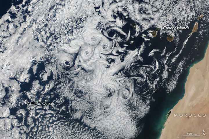
VIIRS records three cloud trails
NASA–NOAA Suomi NPP observed the island wakes on this date. The documentary source contains a single scene, not a sequence from which the rotation period or drift speed can be measured.
Selected observations & analyses
These entries preserve the source’s reported quantities or analyses. They are not a newly processed observational dataset.
| Evidence | Reported value or finding | Provenance |
|---|---|---|
| Visible wake patterns | Three trails of whirling clouds | NASA Earth Observatory interpretation of the 19 March 2023 scene; no numerical wind speed is supplied. |
| Satellite instrument | Suomi NPP / VIIRS | Visible Infrared Imaging Radiometer Suite; a satellite view of the cloud field surrounding the volcanic islands. |
| Observation and publication | 19 March and 15 April 2023 | The first is the scene date; the second is NASA’s article date. They are different parts of the record. |
The atmospheric mechanism
When airflow encounters a sufficiently prominent obstacle, part of it can be diverted around either side. Under suitable conditions, alternating rotating disturbances form downstream. The resulting row of eddies is called a von Kármán vortex street. NOAA’s explanation of another Canary Islands observation describes alternating directions of rotation. That general process explains why a wake can organize into repeated swirls rather than remain a single smooth cloud band.
Clouds are tracers with limitations. A cloud pattern depends on condensation and evaporation as well as motion, so its edge is not a permanent marker attached to a fixed parcel of air. The useful reading begins with the obstacle: locate an island, follow the visible wake away from it, and compare neighboring wakes. This gives a physically grounded interpretation of the pattern without pretending that the image measures every wind between the clouds.
What the evidence does not establish
A spiral in a low cloud deck is not by itself evidence of a tropical cyclone. Here the connection to island obstacles and repeated downstream structure matters. The still image cannot establish how quickly an individual eddy rotates, how long it survives, or what wind a person would feel at sea level. A time series and observations at known heights would be needed to answer those questions. The accompanying NOAA source concerns a different date and is used for mechanism, not as a second frame of this event.
Use geography to test a cloud interpretation. Repetition downstream of an obstacle points to a wake process, while a measured wind speed requires more evidence than a persuasive-looking swirl.
Sources & provenance
- Swirly Clouds in the Canaries NASA Earth Observatory · 2023-04-15Article referenced through original paraphrase. The separately credited NASA documentary image is reproduced under NASA Images and Media Usage Guidelines; item-level permission and file identity are recorded in the media rights register.
- Von Kármán Vortices Make Swirling Cloud Patterns off Canary Islands NOAA NESDIS · 2020-02-20Reference only; original paraphrase; no source media reproduced.
Explanations and diagrams are original educational interpretations. Source institutions have not endorsed or reviewed this publication. How we distinguish evidence from models.