Follow the sequence
Bands begin to organize
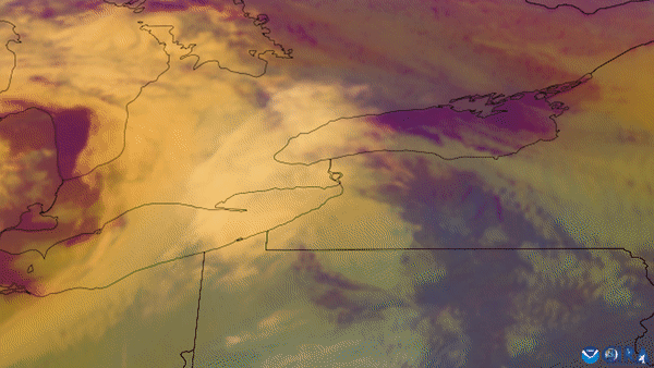
NWS event records describe developing lake-effect bands around southern Erie County. Their placement depended strongly on the airflow across the lake.
Heavy snow concentrates south of Buffalo
Persistent bands delivered extreme local accumulation while nearby locations received much less. Band position mattered as much as the presence of cold air.
The event total is assembled
Reports from observers and stations were collected across the affected area. Later review examined whether proposed short-duration records met measurement standards.
Basis: NOAA National Weather Service, Buffalo [1] · NOAA National Centers for Environmental Information [2] · NOAA State Climate Extremes Committee [3]
Selected observations & analyses
These entries preserve the source’s reported quantities or analyses. They are not a newly processed observational dataset.
| Evidence | Reported value or finding | Provenance |
|---|---|---|
| Buffalo Airport event snow | 36.6 in / 93.0 cm | NCEI Storm Events Database event narrative; total for the multi-day episode. |
| Snowfall pattern | Strong local contrasts around the eastern lakes | NWS Buffalo winter 2022–23 summary; regional event description. |
| Record review | Proposed new 24-hour state records were not accepted | State Climate Extremes Committee memorandum, 30 March 2023; measurement practices were reviewed. |
The atmospheric mechanism
As cold air crosses open, warmer water, heat and moisture enter the lower atmosphere. The resulting instability supports clouds and snow downwind. A long path over water, sufficient moisture and a favorable wind profile help organize intense bands. Small changes in wind direction can shift a band across different neighborhoods, producing sharp gradients in event totals.
The observation lesson is as important as the cloud mechanism. Snowfall is measured using defined procedures; settling, drifting and the frequency of clearing a measuring board affect totals. The review of extraordinary reports did not deny that an extreme storm occurred. It asked whether particular measurements were suitable for a formal record comparison. That distinction is central to reading a number responsibly.
Basis: NOAA National Weather Service, Buffalo [1] · NOAA National Centers for Environmental Information [2] · NOAA State Climate Extremes Committee [3]
What the evidence does not establish
Snow depth on the ground, accumulated snowfall and liquid-water equivalent are different quantities. The airport’s event total should not be labelled a 24-hour amount or applied to the most heavily affected suburbs. The 2023 committee decision concerned proposed state records and observing procedures; it was not a claim that every local snow report was false.
For a narrow-band event, inspect location and time before magnitude. For an extraordinary record, inspect the measuring method as well: precision in the displayed number cannot substitute for a consistent procedure.
Sources & provenance
- Winter 2022–23 Summary NOAA National Weather Service, Buffalo · 2023Reference only; original paraphrase; no source media reproduced.
- Storm Events Database: November 2022 lake-effect snow episode NOAA National Centers for Environmental Information · 2022 event recordReference only; original paraphrase; no source media reproduced.
- State Climate Extremes Committee Decision Regarding 24-Hour State Snowfall Record for New York NOAA State Climate Extremes Committee · 2023-03-30Reference only; original paraphrase; no source media reproduced.
Explanations and diagrams are original educational interpretations. Source institutions have not endorsed or reviewed this publication. How we distinguish evidence from models.