Follow the sequence
Hot inland air reaches Victoria
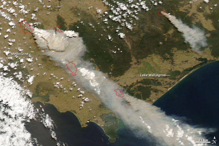
Strong northwesterly flow brought extremely hot and dry air into the state ahead of the change. The setting followed a prolonged dry period.
Exceptional temperatures are measured
Melbourne reached 46.4°C and Hopetoun 48.8°C. These are station air temperatures, not fire temperatures or thermal-image surface values.
The wind direction changes
A late-day change altered wind direction in affected areas. A moving front or trough can change the geometry of a fire’s exposure even as cooler air arrives.
Basis: Australian Bureau of Meteorology [1] · Dowdy et al., Journal of Geophysical Research: Atmospheres [2]
Selected observations & analyses
These entries preserve the source’s reported quantities or analyses. They are not a newly processed observational dataset.
| Evidence | Reported value or finding | Provenance |
|---|---|---|
| Melbourne maximum | 46.4°C on 7 February | Bureau of Meteorology retrospective account; standard air-temperature observation. |
| Hopetoun maximum | 48.8°C on 7 February | Bureau of Meteorology account; north-west Victoria. |
| Documented synoptic pattern | Strong northwesterlies ahead of a change | BOM analysis, with pre-frontal trough and cold front distinguished on its chart. |
The atmospheric mechanism
Hot and dry air favors rapid drying of fine fuels, while strong wind helps move heat and burning material. The atmospheric conditions do not themselves identify an ignition source. During a wind change, a flank of an existing fire can become newly exposed to the driving wind. This is a geometric consequence of changing direction, not a contradiction of the fact that cooler air may be arriving.
The Bureau’s retrospective distinguishes the pre-frontal trough from the colder air behind the main front. That is a useful reminder that not every wind shift is located exactly on a line of greatest temperature contrast. The fronts lab illustrates a sharp boundary for clarity; actual changes have structure, varying timing and local effects. A hypothetical frontal animation should never be interpreted as a fire-spread prediction.
Basis: Australian Bureau of Meteorology [1] · Dowdy et al., Journal of Geophysical Research: Atmospheres [2]
What the evidence does not establish
This is a meteorological reading of a documented day, not a reconstruction of individual fires. Temperature records, wind changes, fuel conditions, ignitions and subsequent fire behavior are different evidence categories. The event cannot be reduced to a single temperature threshold. The scope here does not include operational fire advice, household evacuation decisions or attribution of responsibility for any ignition.
Follow wind direction as carefully as temperature. A cooler air mass can still bring a consequential change in wind geometry, and a one-number “improvement” may conceal that change.
Sources & provenance
- Remembering Black Saturday: the extraordinary weather behind Victoria’s 2009 bushfires Australian Bureau of Meteorology · 2019-02 retrospectiveReference only; original paraphrase; no source media reproduced.
- Pyrocumulonimbus lightning and fire ignition on Black Saturday in southeast Australia Dowdy et al., Journal of Geophysical Research: Atmospheres · 2017Reference only; original paraphrase; no source media reproduced.
Explanations and diagrams are original educational interpretations. Source institutions have not endorsed or reviewed this publication. How we distinguish evidence from models.